Chapter 3: The status of marine protection in Skagerrak
Summary
Marine protected areas (MPAs) are tools for biodiversity conservation in a wide sense including protection of ecosystem function and species interactions. Skagerrak is a productive ‘miniature deep sea’ or submerged fjord with the Norwegian Trench as a prominent feature. The Skagerrak thus offers diverse habitat and nature types harbouring genetically distinct marine populations (see chapter 1). Nature protection in the Skagerrak consists of MPAs ratified under the OSPAR agreement (EU and non-EU members), the Natura 2000 network of MPAs (EU member states) and national parks. Partially protected areas (PPAs) in the form of small-scale spatial protection of European lobster through gear restrictions are implemented widely in Norway and Sweden. Preliminary analyses suggest that marine protection in Skagerrak is weak overall, especially considering areas with regulation of mobile bottom-contacting fishing gear. Further, protected areas in Skagerrak are largely restricted to shallow coastal areas, meaning that important deep-water habitat types are poorly protected. The deepest parts of the Skagerrak are situated in the Norwegian Trench, which is home to vulnerable marine ecosystems, and constitute the most important carbon sink in the greater North Sea region. Establishment of a coherent network of MPAs in the Skagerrak will require international coordination, where marine spatial planning should consider the benefits of protection to biodiversity, fisheries and climate change adaptation and mitigation.
Marine protected areas in the Skagerrak
Nature protection is integral to curbing biodiversity loss and to increasing ecosystems’ resilience to climate change. Recent downscaling of climate projections for the North Sea and Baltic Sea showed that Skagerrak will be subject to profound changes regardless of chosen climate scenario (Ottersen et al., 2025). This, in turn, will impact the ecosystem, its vulnerabilities and ability to provide goods and services. Effective nature protection is deemed necessary to lessen the burden of cumulative anthropogenic pressures. Through the UN CBD Kunming-Montreal Biodiversity Framework the signatory nations have agreed to achieve 30% representative nature protection by 2030 in protected areas or by means of other effective area-based conservation measures (OECMs). Additionally, signatory nations should nominate 30% of degraded ecosystems for restoration (European Commission 2024). The Skagerrak Sea is home to genetically and demographically connected marine populations, vulnerable marine ecosystems and the regions’ most important natural storage of organic carbon. Nature protection in the Skagerrak features marine protected areas (MPAs) ratified under the OSPAR agreement (EU and non- EU members), the Natura 2000 network of MPAs (EU member states), and national parks. Additionally, Skagerrak coastal nations have implemented partially protected areas (PPAs) that constitute potential examples of other effective area-based conservation measures (OECMs), such as lobster reserves, regulations for threatened fish populations and coastal trawl limits. In Norwegian Skagerrak, this limit constitutes the coastal zone out to the 60 m depth contour. In Sweden, the trawl limit constitutes the coastal zone out to 3 nm from the baseline. In Denmark, gear restrictions apply to bottom trawling within 3 nm from the low water line (e.g., max. 160 kg trawl door weight, except when targeting sandeel) and several non-trawling areas are specified in fjords and coastal areas (Anon, 2019).
Historically, the productive Skagerrak ecosystem was home to diverse small- and medium-scale fisheries that were important for the regions’ food security and generated a multitude of livelihoods in coastal communities. Modern fisheries operations in the Skagerrak are still economically important and are now primarily based on mobile bottom-contacting fisheries of mixed vessel size for northern shrimp, Norway lobster and fish including certain high-value demersal fish species (ICES, 2022). The pelagic fishery is small as quotas have been moved to the North Sea to protect Western Baltic Herring.
Several instruments for marine protection are represented in the Skagerrak. OSPAR marine protected areas are areas ratified under the OSPAR agreement. Natura 2000 marine protected areas are designated under the EU Birds- and Habitats Directives. In addition, there are national parks with marine areas designated under national environment protection legislation (Norway). These areas include fully and partially protected areas designated under the EU common fisheries policy and national fisheries legislation.
Globally, there is high variation in regulations of activities inside MPAs spanning from fully protected no-take zones to multiple-use areas. The regulation level of a MPA is considered as a good indicator of their ability to achieve management goals, e.g. conservation of marine biodiversity (Costa e Horta et al., 2016; Grorud-Colvert et al., 2021; Aminian-Biquet et al., 2024).
Bratten MPA with fully protected no-take zones
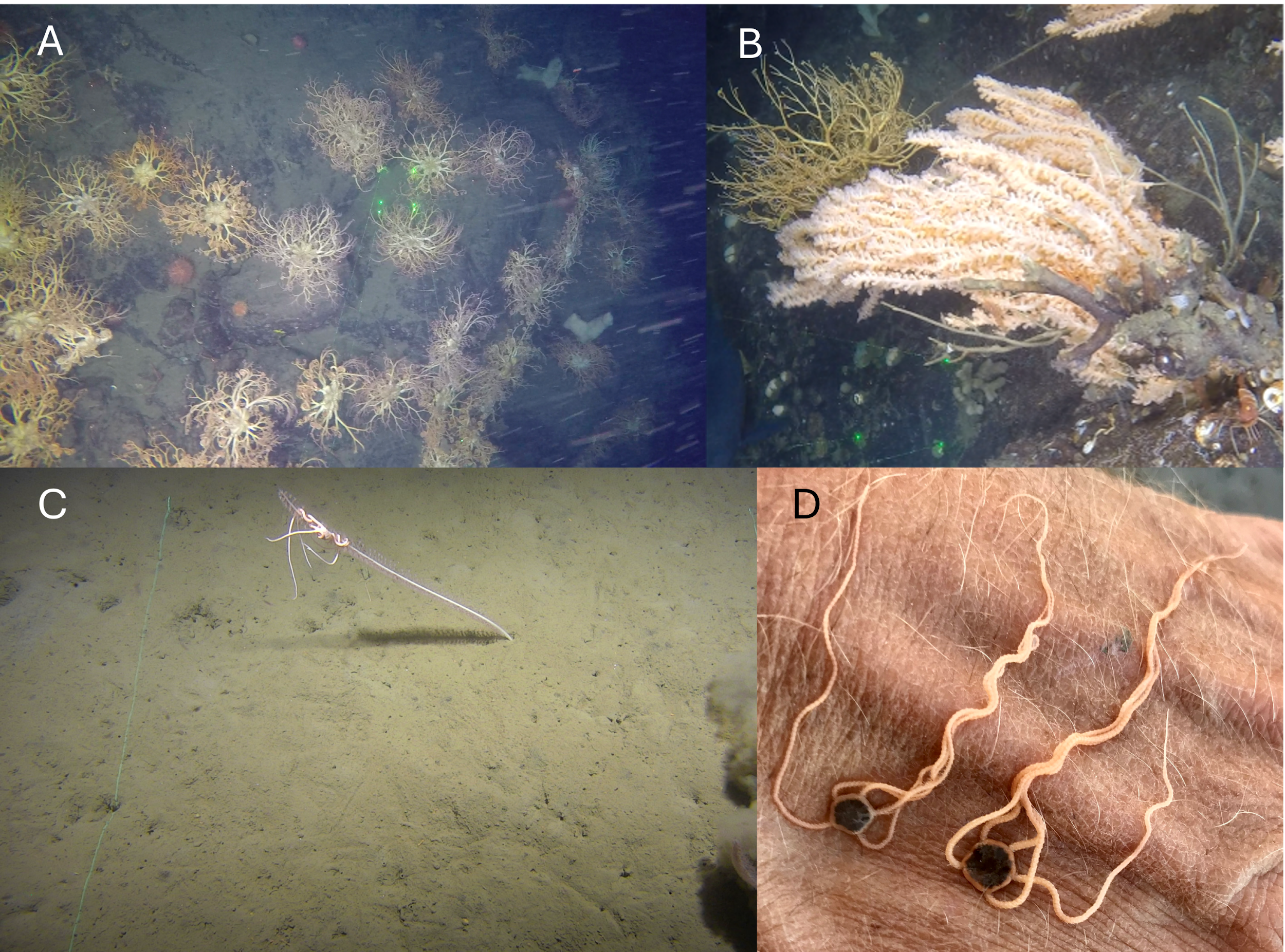
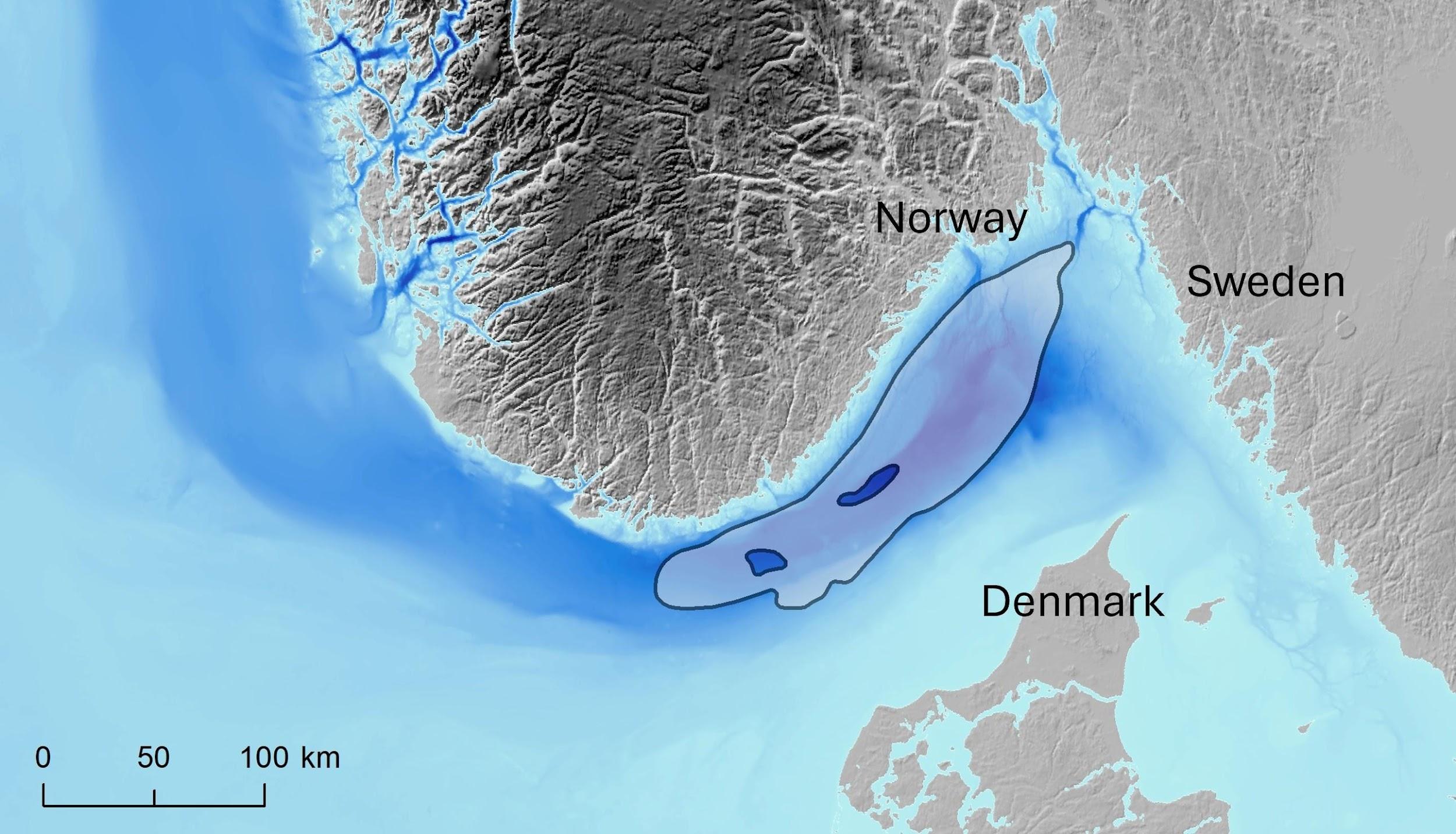
The Bratten is a large (1 209 km2) MPA hosting species and habitats of high conservation value with spectacular bathymetry characterised by steep rock walls, canyons and pockmarks on the slope (100–500 m) towards the Norwegian Trench in the Skagerrak (see Figure 3.1). The exposed rock walls host deep water coral gardens, sponge communities, large predatory fish, and dense sea pen fields in the surrounding soft bottoms (Figure 3.2). Extensive inventories and seabed mapping started in 2003 and since then several reports of biodiversity and habitats have been published. A major challenge for the management and conservation of the area was that Bratten is situated within one of the most important fishing grounds in the Skagerrak for Northern shrimp Pandalus borealis and demersal fish, located outside territorial waters in the Swedish EEZ, and intensively fished mainly by bottom trawlers from Sweden and Denmark. In addition, the integration between the EU nature conservation policy and the Common Fisheries Policy (CFP) was poorly developed during the early phases of the process.
The Bratten MPA was designated as a Natura 2000 site (SCI) for reef structures in 2011 and later in 2012 became part of the Convention for the Protection of the Marine Environment of the North-East Atlantic’s (OSPAR’s) network of MPAs. The development of fisheries regulations was preceded by work in the Interreg project “Hav möter land” (Sea meets Land) 2010 - 2013 lead by the County Administrative Board of Västra Götaland (CAB) in where extensive stakeholder consultations with representatives of the fishing industry, sport fishermen, various national authorities and research institutions from Sweden, Norway and Denmark were held (Länsstyrelsen, 2013). Following recommendations by CAB, the management measures were enforced by the EU commission in 2017 after additional formal EU procedures resulting in a so-called Joint Recommendation by Sweden, Denmark and Germany. The measures include the establishment of no-take zones covering 27% of the area, where all commercial fisheries were prohibited. For control purposes compulsory use of automatic identification system (AIS) for all vessels fishing in the area was implemented. Similarly, conservation measures for recreational fisheries were enforced in 2017 through national legislation by closing several of the zones also to recreational fisheries.
Recent analysis of fishing patterns in the Bratten MPA show that the trawlers ceased to fish in the no-take zones and intensified their efforts in passages between zones and to the north-east within the MPA (Feary et al., in press). There was no significant overall reduction in fishing effort in the MPA, and no indications of displacement to areas outside the Bratten MPA. Rather, the variability in effort within the MPA correlated with the effort and fishing opportunities linked to the variation in availability of northern shrimp between years within the Skagerrak as a whole. As communicated by the active fishermen during the negotiation process for fishing regulations in Bratten, passages mainly in the North to South direction were of great importance to the ongoing fishery in the area as the trawlers follow the slope in that direction, and that hauls continue for long distances through the area. As the most utilized passages identified in the Bratten area were kept open to minimize the conflict between conservation targets and the trawl fishery, it is to these passages the trawlers reallocated, and consequently the effort has increased there. A large zone in the west that was closed had very little effort the years prior to the closure, and no significant shift in effort from that area was expected.
The fishery regulations in the Bratten MPA were negotiated with fishers’ organisations from Sweden and Denmark, and authorities considered the arguments from the fishers that it was important to keep passages through the area open. This may explain that effort could be withheld within the MPA, and that compliance with the regulations has been high. In addition, the regulations have been strongly enforced by detailed vessel monitoring covering essentially all vessels operating in the MPA.
Conclusion
Judging from the Bratten case, marine conservation and the innate interplay with fisheries management constitute slow regulatory processes that in many aspects have evolved over the past 20 years. There has been strong improvement of techniques and resources for inventories and mapping, e.g. multibeam bathymetry in high resolution, underwater techniques with remotely operated vehicles (ROV) and towed camera systems, and availability of modern research vessels that can operate in the offshore environment. In parallel, there has been a strong improvement of techniques and resources for mapping of the fisheries over the years. Further, the willingness from the fishing industry to take part in processes has increased, and detailed satellite tracking of fishing vessels combined with logbook information on gear use provide a neutral basis for trade-offs to be made by managers between fishing opportunities and conservation targets. In summary, a solid knowledge basis is necessary for progress, but a strong burden of proof is imposed on environmental management authorities regarding the need for conservation measures. Finally, a strong driver for progress has been obligations under the EU habitats directive.
Raet national park and ‘Protect Raet’ pilot project
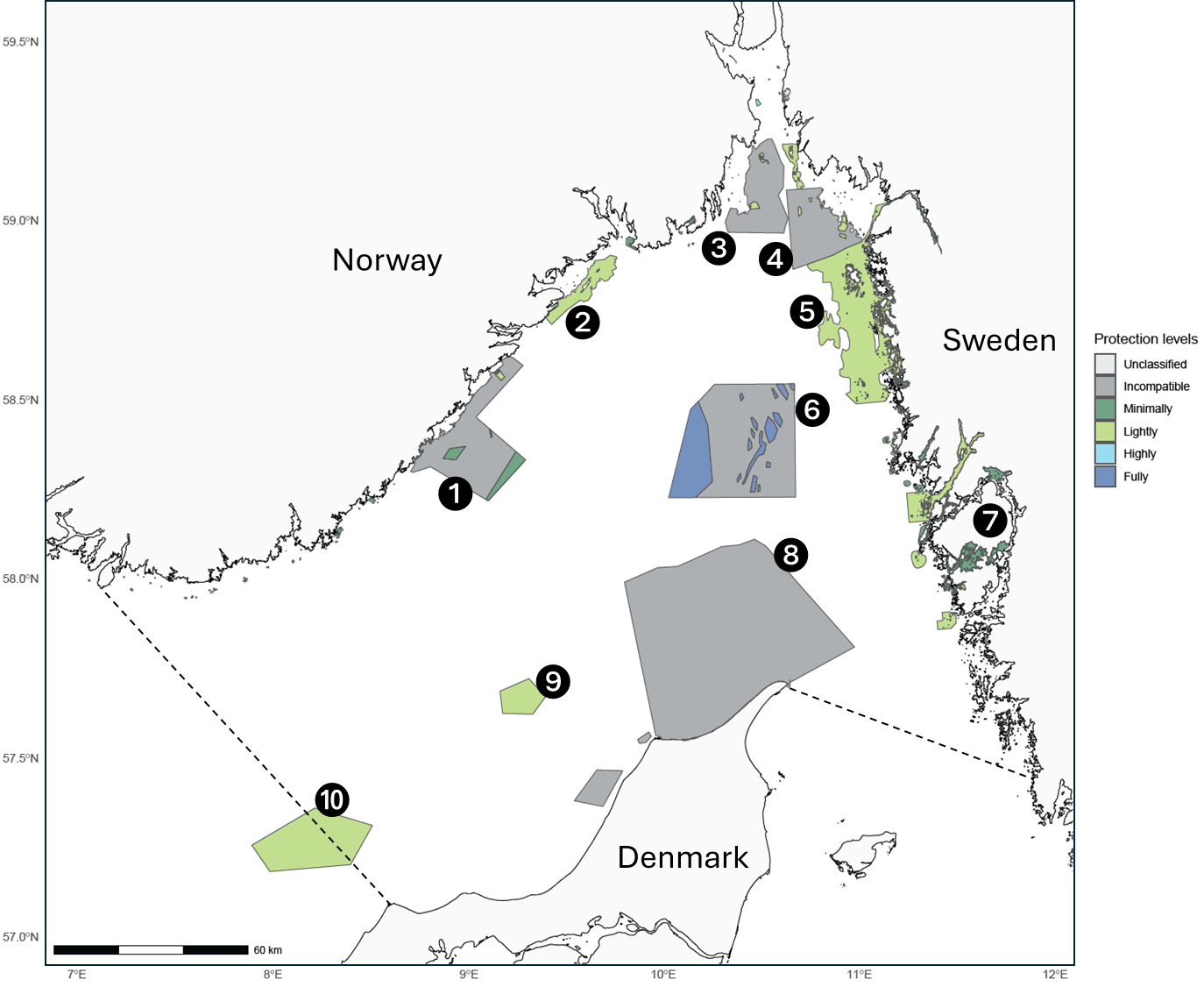
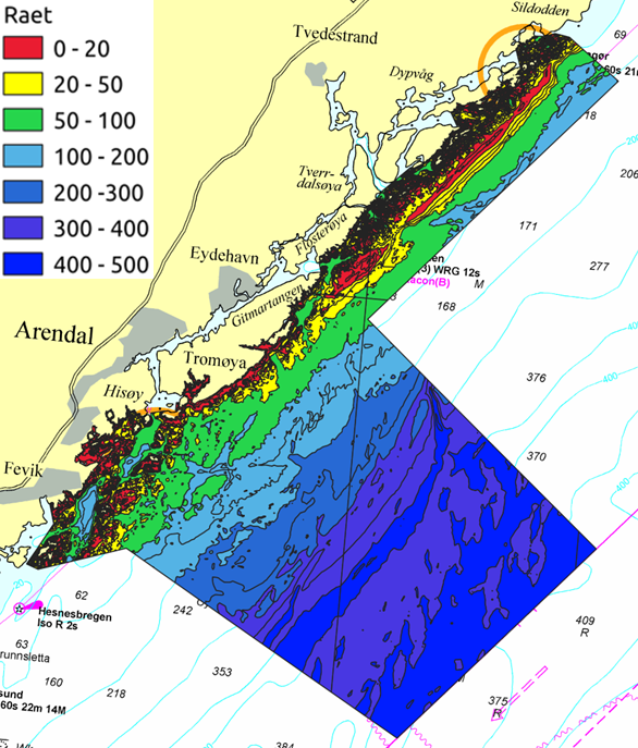
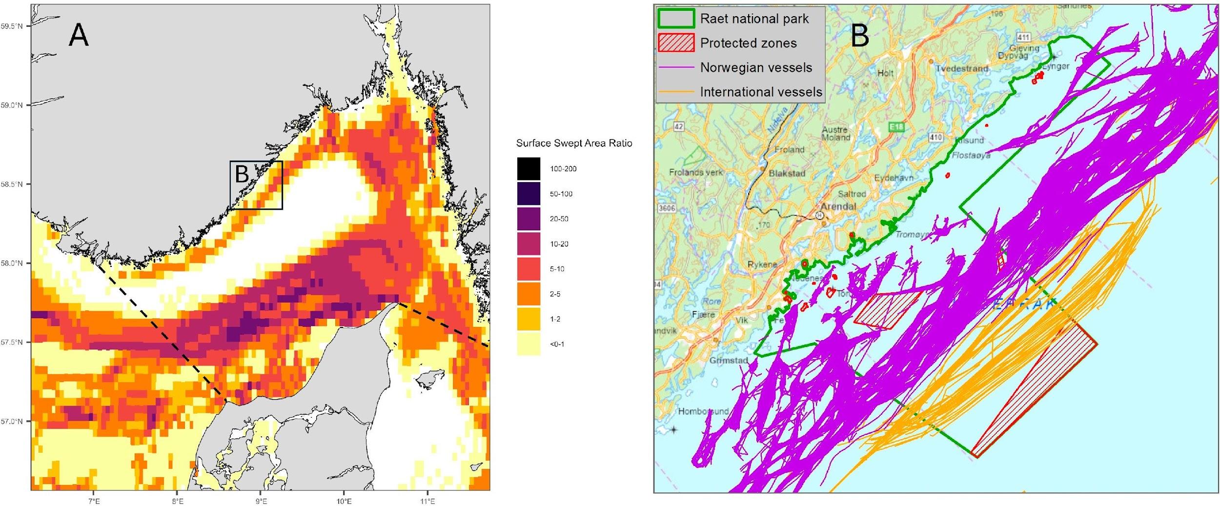
Since 2009, national parks with marine areas under national environment protection legislation have been designated in Norway. Four marine national parks have been implemented along the Norwegian coast of Skagerrak (see area 1-4 in Figure 3.1). Raet national park on the south-eastern Skagerrak coast of Norway was implemented in 2016 and covers 595 km2 of sea area. The national park (NP) stretches from shallow coastal areas and out to 12 nautical miles with depths down to 500 meters (Figure 3.3). However, except for three trawl free areas and two lobster reserves, covering approximately 10 % of the NP, there are no special management measures directed at fisheries in the NP. In the preliminary evaluation of protection level conducted within the SAMSKAG project, the NP has thus been identified as incompatible with marine protection (Figure 3.1).
The local municipalities bordering the national park (Tvedestrand, Arendal and Grimstad) have together with the Agder county municipality initiated a regulatory process to increase the protection level of the NP (the ‘Protect Raet’ project). The project aims to strike a knowledge-based balance between conservation and use. Therefore, development of a zoning-plan has been suggested with varying degrees of regulations between zones (Kleiven et al., 2024).
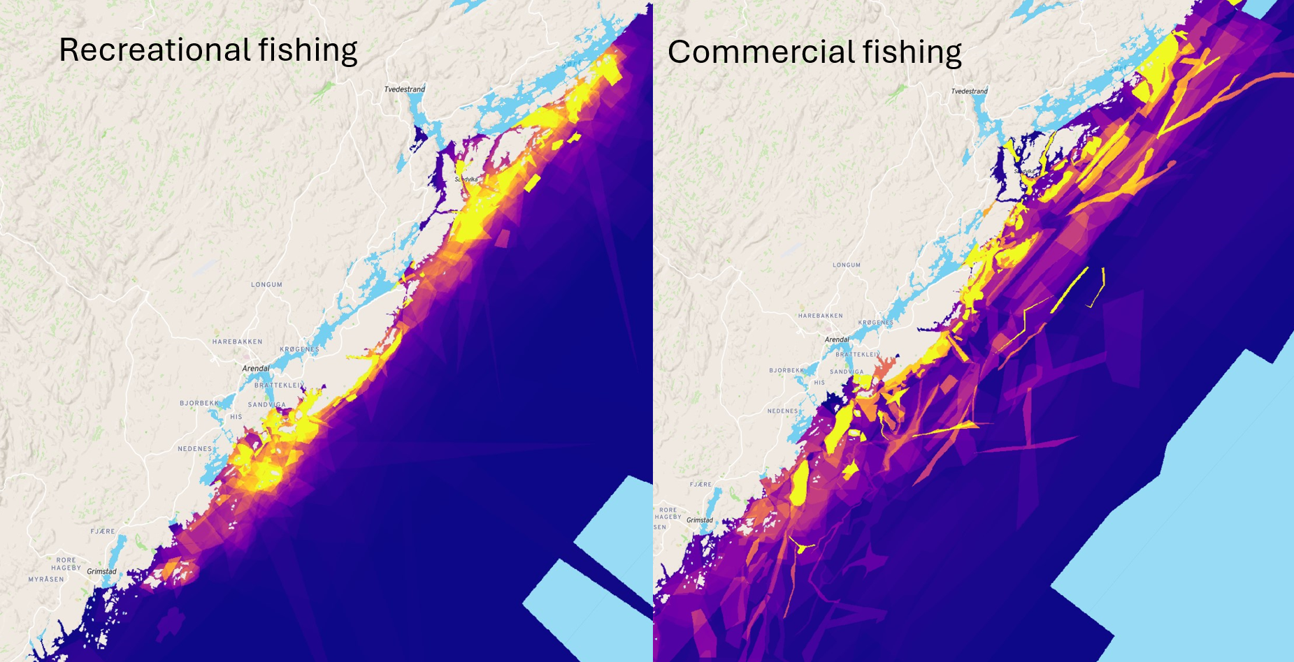
This bottom-up approach seeks to include stakeholders throughout the different steps of the process, including a working group consisting of commercial and recreational fishers, environmental NGOs, research institutes and municipal administration. A survey has been conducted through the online spatial planning software SeaSketch to map the different human uses of the NP (Figure 3.4). In addition, before-data on fish communities and ecosystems in both shallow and deeper areas are collected to evaluate future effects of potential management actions.
Lobster reserves: ‘single-species protection’ and marine conservation laboratories
Small-scale partially protected areas (PPAs) have been implemented in both Sweden and Norway with the main aim to restore and protect European lobster (Homarus gammarus) populations. Within the lobster reserves, passive gear such as gill nets, traps and fyke nets are prohibited. Along the Skagerrak coast in Norway there are to date 28 lobster reserves covering 89 km2 (mean size 3.2 km2). Research monitoring from both countries shows positive effects on lobster density, mean size, biomass, reproductive potential and spill-over (Caleb et al., 2016; Bergström et al., 2022; Knutsen et al., 2022; Torgan 2024; Van Hoey et al., 2024). Scientific long-term monitoring of lobster reserves and fished control areas has demonstrated that the lobster fishery has a strong impact on lobster populations and that depleted local populations can be rebuilt if fishing pressure is reduced or eliminated locally (Figure 3.5).
The conservation effects of lobster within lobster reserves are well documented. However, lobster reserves do also have the potential to strengthen the general lobster population and secure improved fisheries management and catches. There are two ways lobster reserves also can contribute to fisheries; 1) Recruitment effect: Larvae have the potential to spread out to surrounding fished areas. In the Kåvra lobster reserve in Sweden, it is estimated that the reproductive potential has increased by a factor between 7 to 9 (Bergström et al., 2022). 2) Spillover effect: Higher densities of lobsters within reserves can lead to increased catches close to reserve borders. For a 5 km2 lobster reserve in Norway it has been shown that lobster catches increased outside the borders 9 years after implementation (Figure 3.6, van Hoey et al., 2024).
The monitoring has also shown that brown crab (Cancer pagurus) populations decrease in the lobster reserves, most likely due to increased interspecific competition with rebounding lobster. Even though some positive effects have been detected for Atlantic cod (Gadus morhua) (Moland et al., 2013; Fernández-Chacón et al., 2015) and wrasses (Halvorsen et al., 2017), the potential wider ecosystem effects of lobster reserves are uncertain and probably negligible due to the limited size of most lobster reserves and continuation of hook and line fishing within the areas (LaScala-Gruenewald et al., 2021; Perry et al., 2025). There is a need for further research on potential ecosystem effects in lobster reserves and their potential to be defined as OECMs. Data on fish communities inside and outside lobster reserves are being collected and will help to answer these questions in the future.
Considerations for holistic marine protection in the Skagerrak
Vulnerable Marine Ecosystems (VMEs) and threatened nature types
The Norwegian Trench and the outer region of the Oslofjord are defined as especially valuable areas (SVO’s) due to the richness of ecosystem components meeting the criteria of Ecologically and Biologically Significant marine Areas (EBSA) (Eriksen et al., 2021; Meld. St. 21). The deeper part of the Norwegian Trench is mainly situated within the Norwegian exclusive economic zone (EEZ). It delivers a series of ecosystem functions in supporting essential ecosystems and key species for Skagerrak, fragile and vulnerable deep-sea life (Álvarez et al. 2019) (see Figure 3.2). When assessed according to the EBSA criteria, it scored medium to high on uniqueness for benthic communities, zooplankton and fish. Zooplankton and fish scored equally high for six of the seven criteria, except naturalness. Based on water exchange with the North Atlantic Ocean and the refuge areas in the stable environments of the deep trench, it is important for phyto- and zooplankton, particularly Calanus finmarchicus, which is of key importance in the food web of the Skagerrak and North Sea ecosystem.
‘Coral gardens’, ‘Cold water coral reefs’ and ‘Sea pen fields’ are types of vulnerable marine ecosystems (VMEs) found in the Skagerrak (Buhl-Mortensen et al., 2023). These habitats consist of species that are vulnerable to the impacts of bottom-contacting fishing gear. They provide niches for a number of other species and nursery and feeding areas for demersal fish. The nature type ‘Aphotic mud’ in the Skagerrak is assessed as Near Threatened (NT) in the Norwegian Red list of Ecosystems (aphotic = beyond the reach of daylight) (Buhl-Mortensen et al., 2018). For aphotic mud, the impact of bottom trawling is also implicated in the assessment. In this case it is based on environmental degradation due to the loss of organisms and functions in the benthic ecosystem.
Burial of organic carbon in deep marine sediments and protection of carbon stocks
Continental margin sediments accumulate organic carbon at scales much larger than vegetated coastal ecosystems because of their larger extent, and because they are accumulation bottoms rather than erosion bottoms. The Norwegian Trench constitutes the major carbon sink in the greater North Sea region (Diesing et al., 2024) (Figure 3.7). Studies are now exploring to what extent management interventions could increase accumulation rates by minimizing anthropogenic disturbance of seafloor sediments through bottom-contacting fisheries. Recent geospatial modeling studies have estimated regional and global aqueous CO2 emissions resulting from bottom-trawling- induced remineralization of sedimentary organic carbon, with some studies proposing carbon protection zones (CPZs) as an effective climate protection measure (Porz et al., 2023; Zhang et al., 2024).
The ‘Skagerrak agreement’: reciprocal access to fishing grounds
Based on the principle of upholding traditional fishing rights, Skagerrak is managed according to the ‘Skagerrak agreement’ between Norway and the European Union on reciprocal access to fishing grounds in the Skagerrak for vessels flying the flags of Denmark, Norway and Sweden. The agreement allows Danish, Swedish and Norwegian vessels to operate within each country’s economic zone and territory outside the 4 nautical mile limit. The agreement is a remnant of the time prior to the United Nations Convention on the law of the Sea from 1982, and a continuation of the 1966 agreement securing reciprocal access to Skagerrak (Anon, 2015) (see also Chapter 2). Future marine conservation processes will need to incorporate and take into account the legal implications and precedents that are implicit in this agreement.
How effective are present protection instruments in the Skagerrak?
Preliminary analyses based on regulation-based classification according to the authoritative guidelines of the MPA guide (Grorud-Colvert et al., 2021; Aminian-Biquet et al., 2024) suggest that the present marine protection in the Skagerrak is insufficient in area coverage, ineffective, and unlikely to confer desired outcomes and regional ecosystem benefits. Costa e Horta et al., (2016) developed a regulation-based classification tool for MPAs to predict the MPAs expected conservation outcomes. In collaboration with the EU funded MARHAB project, the SAMSKAG project has developed a preliminary analysis of MPAs in Skagerrak. The analysis showed that the total coverage of these protection instruments is 22 % of Skagerrak’s total area. However, less than 7 % of the total area of Skagerrak fall within protection instruments that are likely to confer protection benefits on ecosystems (Figure 3.1). Conversely, a large proportion of the MPAs are found to be incompatible with marine protection. Industrial bottom trawling is found to be incompatible with marine protection (IUCN, 2021; Costa e Horta et al., 2016; Grorud-Colvert et al., 2021), a fishing gear permitted in most MPAs in Skagerrak, and a fishery which is chronic in this ecosystem (see Figure 3.6). This means that the best available scientific knowledge does not support that there are any reasons to expect positive conservation outcomes of these MPAs. Based on their current regulation level, such ‘incompatible’ MPAs should not be counted in the respective coastal nation's effort to meet the aims laid down in the Kunming-Montreal Biodiversity Framework. Recently, the Danish Biodiversity Council (an independent expert panel) recommended that bottom trawling and other mobile bottom-contacting gear should not be permitted inside marine protected areas (Biodiversitetsrådet, 2024).
Increasing the protection levels of existing instruments will help (see Fig. 3.8B), but marine protection aiming to achieve benefits for biodiversity, fisheries and carbon sequestration would gain from a regional collaborative process where the best available science is incorporated in designing and siting optimal spatial management measures.
Population structure – where species are divided into multiple distinct units or populations – is an evident pattern among organisms within the Skagerrak. Such structure is apparent especially among coastal sites and between coastal and offshore sites. However, population connectivity patterns have yet to be fully utilized in designing coherent networks of marine protection in Skagerrak (see Chapter 1). Mobile bottom-contacting (mainly bottom trawl) fisheries target the Skagerrak basin down to 400–500 meter depth (Figure 3.8A). A holistic MPA network design in Skagerrak should consider patterns in population structure and population connectivity, as well as configuration and representativity of habitats, and prevailing fishing pressure. Some of the most productive sites, which are essential to include in MPA networks to maximise ecosystem benefits, are likely to be heavily targeted by fisheries, thus risking displacement and intensification of fishing effort in adjacent unprotected areas. To keep negative impacts on fisheries to a minimum while maximizing conservation benefits, it is essential to conduct systematic conservation planning, where maps of conservation values, human pressures and socio-economic interests are considered. An effective MPA network in Skagerrak, taking both broad conservation and socio-economic objectives into account, would benefit from an international scientific advisory committee including representatives from Norway, Sweden, Denmark and the EU commission.
Policy brief on protecting the Skagerrak for biodiversity, food and climate
As part of the SAMSKAG project a policy brief was produced in which the scientific rationale for marine protection was placed in context with the Skagerrak ecosystem and the main findings also presented herein were summarised (Moland et al., 2024). The following recommendations for management were listed.
- Achieving effective marine protection in the Skagerrak depends on sufficient coverage of areas that limit or remove the negative ecosystem effects of fisheries and protect against pressures from other human activities.
- The Skagerrak contains vulnerable marine ecosystems and threatened nature types. To better incorporate protection of biodiversity throughout habitats and nature types, protection must be both horizontally wide and vertically deep and target biodiversity and important ecosystem services.
- MPA network design and marine spatial planning in the Skagerrak need to consider both coastal and offshore marine areas, where representativity, biodiversity, population connectivity and carbon sinks are considered.
- Taking human pressures and socio-economic interests into account, a holistic design of an effective MPA network in Skagerrak will benefit from an international scientific advisory committee.
References
Álvarez, H., Perry, A.L., Blanco, J., Conlon, S., Petersen, H.C., Aguilar, R. 2019. Protecting the North Sea: Norway. Oceana, Madrid. 96 p. https://europe.oceana.org/wp-content/uploads/sites/26/d_files/oceana_2019_norway_web.pdf
Aminian-Biquet, J., Gorjanc, S., Sletten, J., Timothé, V., Laznya, A., Vaidianu, N., Pakkasmaa, S., Claudet, J., Young, J., Horta e Costa, B. 2024. Over eighty percent of the European Union's marine protected area only marginally regulates human activities. One Earth 7:1614-1629. https://doi.org/10.1016/j.oneear.2024.07.010
Anon. 2015. Agreement between the Kingdom of Norway and the European Union on reciprocal access to fishing in the Skagerrak for vessels flying the flag of Denmark, Norway and Sweden. https://lovdata.no/dokument/TRAKTATEN/traktat/2015-01-15-1
Anon. 2019. Trawlbekentgjørelsen, BEK nr 366 af 02/04/2019. https://www.retsinformation.dk/eli/lta/2019/366
Biodiversitetsrådet. 2024. Notat: Anvendelse af bundslæbende fiskeredskaber i beskyttede havområder - effekten på den marine biodiversitet. https://www.biodiversitetsraadet.dk/pdf/2024/10/Bundslaebende_Notat_31.10.2024.pdf
Bergström, U., Berkström, C., Sköld, M., Börjesson, P., Eggertsen, M., Fetterplace, L., Florin, A.-B., Fredriksson, R., Fredriksson, S., Kraufvelin, P., Lundström, K., Nilsson, J., Ovegård, M., Perry, D., Sundelöf, A., Wikström, A., & Wennhage, H. 2022. Long-term effects of no-take zones in Swedish waters. Department of Aquatic Resources, Swedish University of Agricultural Sciences. https://doi.org/10.54612/a.10da2mgf51
Buhl-Mortensen, P., Bakken, T., Oug, E., Rapp, H.T. 2018. Marine deep waters. Norwegian Red List of Ecosystems 2018. Norwegian Biodiversity Information Centre. Downloaded (25.09.2024) from https://www.biodiversity.no/Pages/317605/Marine_deep_waters
Buhl-Mortensen, L., Thangstad, T. H., Søvik, G., Wehde, H. 2023. Sea pens and bamboo corals in Skagerrak and the Norwegian trench. Marine Biology Research 19:191–206. https://doi.org/10.1080/17451000.2023.2224967
Calef, Z. 2016. Quantifying the Impact of a Network of Small-Scale MPAs on Reproductive Potential of European Lobster (Homarus gammarus) in the Norwegian Skagerrak [Master’s thesis]. Technical University of Denmark.
Diesing, M., Paradis, S., Jensen, H., Thorsnes, T., Bjarnadóttir, L.R., Knies, J. 2024. Glacial troughs as centres of organic carbon accumulation on the Norwegian continental margin. Communications Earth & Environment 5:327. https://doi.org/10.1038/s43247-024-01502-8
Eriksen, E., van der Meeren, G.I., Nilsen, B.M., von Quillfeldt, C.H., Johnsen, H. 2021. Particularly valuable and vulnerable areas (SVO) in Norwegian seas - Environmental values (English summary). Rapport fra havforskningen 2021-26. https://www.hi.no/hi/nettrapporter/rapport-fra-havforskningen-2021-26
EU Commision 2024. Regulation (EU) 2024/1991 of the European Parliament and of the Council of 24 June 2024 on nature restoration and amending Regulation (EU) 2022/869 (Text with EEA relevance) http://data.europa.eu/eli/reg/2024/1991/oj
Feary, D.A., van Hoey G., Aranda, M., Brown, E.J., Metz, S., Reid, D., van der Valk, O, van Kooten, T., Abreu, S., Bergman, J., Castro, N., Carvalho, G., Eggertssen, M., Emerit, A., Fetterplace, L., Folhas, H., Hamon, K; IJntema, G., Jiménez-Navarro, S., Martín-Sosa, P., Mendoza, J.C., Mommens, M-P., Pecceu E., Pereira, R., Putnis, I., Quirijns, F.J., Robert, M., Sköld, M., Sys K., Tully, O., Ustups, D., Valentinsson, D., Vallina, T., van der Reijden, K.J., Verlé K., Wakeford, R.C. Mapping of marine protected areas and their associated fishing activities: Baltic and North Seas, Atlantic EU Western Waters and EU Outermost Regions (MAPAFISH), Publications Office of the European Union, 2023 (in press)
Fernández-Chacón, A., Moland, E., Espeland, S. H., and Olsen, E. M. 2015. Demographic effects of full vs. partial protection from harvesting: inference from an empirical before-after control-impact study on Atlantic cod. Journal of Applied Ecology 52:1206–1215. https://doi.org/10.1111/1365-2664.12477
Grorud-Colvert, K., Sullivan-Stack, J., Roberts, C., Constant, V., Horta E Costa, B., Pike, E. P., Kingston, N., Laffoley, D., Sala, E., Claudet, J., Friedlander, A. M., Gill, D. A., Lester, S. E., Day, J. C., Gonçalves, E. J., Ahmadia, G. N., Rand, M., Villagomez, A., Ban, N. C., … Lubchenco, J. 2021. The MPA Guide: A framework to achieve global goals for the ocean. Science 373:6560. https://doi.org/10.1126/science.abf0861
Halvorsen, K. T., Sørdalen, T. K., Vøllestad, L. A., Skiftesvik, A. B., Espeland, S. H., & Olsen, E. M. 2017. Sex- and size-selective harvesting of corkwing wrasse (Symphodus melops)—A cleaner fish used in salmonid aquaculture. ICES Journal of Marine Science 74:660–669. https://doi.org/10.1093/icesjms/fsw221
Havs- och Vattenmyndigheten 2016. Proposal for Fisheries Conservation Measures in the Marine Protected Area, Bratten located in the Swedish EEZ of Skagerrak
Horta e Costa, B., Claudet, J., Franco, G., Erzini, K., Caro, A., & Gonçalves, E. J. 2016. A regulation-based classification system for Marine Protected Areas (MPAs). Marine Policy 72:192–198. https://doi.org/10.1016/j.marpol.2016.06.021
ICES 2022. Greater North Sea ecoregion – fisheries overview. In: Report of the ICES Advisory Committee, 2022. ICES Advice 2022, section 9.2. https://doi.org/10.17895/ices.advice.21641360
IUCN 2021. Motion 066–Guidance to identify industrial fishing incompatible with protected areas. International Union for Conservation of Nature. https://www.iucncongress2020.org/motion/066
Kleiven, A.R., Thorbjørnsen, S.H., van der Meeren, G.I., Freitas, C., Naustvoll, L.J., Moland, E., Norderhaug, K.M., Falkenhaug, T., Reamon, M., Hagestad, S., Eckbo, N. 2024. Raet nasjonalpark - Kunnskap og råd for bevaring av marint naturmangfold. Rapport fra havforskningen 2024-38. https://www.hi.no/hi/nettrapporter/rapport-fra-havforskningen-2024-38
Kleiven, A.R., Thorstensen, H.S., Norderhaug, K.M., van der Meeren, G., Dunlop, K.M., Thorbjørnsen, S.H., Fernandez-Chacon, A., van der Meeren, T., Moland, E., Skern-Mauritzen, M., Haarr, M.L. 2024. Hvor godt fungerer marine bevaringsområder? En litteraturstudie. SALT Rapport 1090.
Knutsen, J. A., Kleiven, A. R., Olsen, E. M., Knutsen, H., Espeland, S. H., Sørdalen, T. K., Thorbjørnsen, S. H., Hutchings, J. A., Fernández-Chacón, A., Huserbråten, M., Villegas-Ríos, D., Halvorsen, K. T., Nillos Kleiven, P. J., Langeland, T. K., & Moland, E. (2022). Lobster reserves as a management tool in coastal waters: Two decades of experience in Norway. Marine Policy 136:104908. https://doi.org/10.1016/j.marpol.2021.104908
LaScala-Gruenewald, D.E., Grace, R.V., Haggitt, T.R., Hanns, B.J., Kelly, S., MacDiarmid, A., Shears, N.T. 202. Small marine reserves do not provide a safeguard against overfishing. Conservation Science and Practice 2021:e362. https://doi.org/10.1111/csp2.362
Länsstyrelsen (2013). Förslag till fiskeregleringar i Bratten. Report 2013:103 www.lansstyrelsen.se/vastragotaland/Sv/publikationer/2013/Pages/2013-103.aspx
Meld. St. 21 (2023-2024), Barentshavet og havområdene utenfor Lofoten, Norskehavet, og Nordsjøen og Skagerrak. Innst. 375 S (2023-2024), Norwegian Parliament White paper 14.06.2024. (In Norwegian)
Moland, E., Olsen, E. M., Knutsen, H., Garrigou, P., Espeland, S. H., Kleiven, A. R., André, C., & Knutsen, J. A. 2013. Lobster and cod benefit from small-scale northern marine protected areas: Inference from an empirical before–after control-impact study. Proceedings of the Royal Society B: Biological Sciences 280:20122679. https://doi.org/10.1098/rspb.2012.2679
Moland, E., Sköld, M., Brown, E.J., Bergström, U., Kleiven, A.R., van der Meeren, G.I., Søvik, G., Henriksson, S., André, C. 2024. Protecting the Skagerrak for biodiversity, food and climate. Nordic Council of Ministers. Nord 2024:031. http://dx.doi.org/10.6027/nord2024-031
Ottersen, G., Arneborg, L., Maar, M., Almroth-Rosell, E., Fredriksson, S., Gonzalez, S., Hansen, C., Hieronymus, M., Hordoir, R., Larsen, J., Liu, Y., Nilsen, I., Sandø, A.B., Saraiva, S., Schourup-Kristensen, V., and Skogen, M.D. 2025. Nordic Climate Scenarios - Effects of climate change on future environment and marine life in the Nordic sea areas. TemaNord 2025:527 http://dx.doi.org/10.6027/temanord2025-527
Perry, D., Wikström, A., Wennhage, H., Sköld, M., Sundelöf, A. 2025. Lobster-specific MPA offers little refuge for fish: long-term closure does not compensate for insufficient size. Ocean and Coastal Management, 261:107535 https://doi.org/10.1016/j.ocecoaman.2024.107535
Porz, L., Zhang, W., Christiansen, N., Kossack, J., Daewel, U., Schrum, C. 2024. Quantification and mitigation of bottom-trawling impacts on sedimentary organic carbon stocks in the North Sea, Biogeosciences 21:2547–2570. https://doi.org/10.5194/bg-21-2547-2024
Torgan, P. 2024. The effect of small-scale partially protected areas on European lobster (Homarus gammarus) abundance and demographics – a citizen science based study [Master thesis], Norwegian University of Science and Technology. https://ntnuopen.ntnu.no/ntnu-xmlui/handle/11250/3154986?show=full
Van Hoey, G., Feary, D. A., Brown, E. J., Buyse, J., Mangi, S. C., Vallina, T., van Kooten, T., Abreu, S., Aranda, M., Berstrom, U., Castro, N., Kleiven, P. J. N., Monsier, P., Peat, W., Rakowski, M., Robert, M., Stacy, R., Uriarte, A., Whitley, C., … Quirijns, F. J. 2024. Assessing spillover from marine protected areas to adjacent fisheries: Baltic and North Seas, Atlantic EU Western Waters and Outermost Regions: final report. Publications Office. https://data.europa.eu/doi/10.2926/35237
Zhang, W., Porz, L., Yilmaz, R., Wallmann, K., Spiegel, T., Neumann, A., Holtappels, M., Kasten, S., Kuhlmann, J., Ziebarth, N., Taylor, B., Ho-Hagemann, H.T.M., Bockelmann, F-D., Daewel, U., Bernhardt, L., Schrum, C. 2024. Long-term carbon storage in shelf sea sediments reduced by intensive bottom trawling. Nature Geoscience 17:1268–1276. https://doi.org/10.1038/s41561-024-01581-4