4. Case studies: Nature-based solutions in the Nordic countries
This section presents different nature-based solutions implemented in Åland, Sweden, Norway, and Denmark, focusing on their socio-economic benefits.
Åland
Nabbens Wetlands in Mariehamn
Description
With the main purpose of purifying storm water and increasing biodiversity in the Baltic Sea, a wetland at Nabben (a coastal area next to Mariehamn in the bay Slemmern) was constructed between 2016 and 2020. The three-hectare area consists of small streams, a sediment pond, and a wetland. Every year approximately 1.000.000m3 of water passes through the wetland. Passing water is first filtered through sand in a meandering flow, then it passes through the sediment pool where water is purified of phosphorus and heavy metals. Next the water enters the wetland, where nitrogen is being transformed or taken up by vegetation. Estimates by the municipality of Mariehamn suggest that the wetland annually purify 800 kg of nitrogen, 100 kg of phosphorus and 1.5 ton of plastics. Wetlands are also good at sequestering carbon and estimates on annual carbon sequestration in Nabben comes to between 5 and 40 ton.
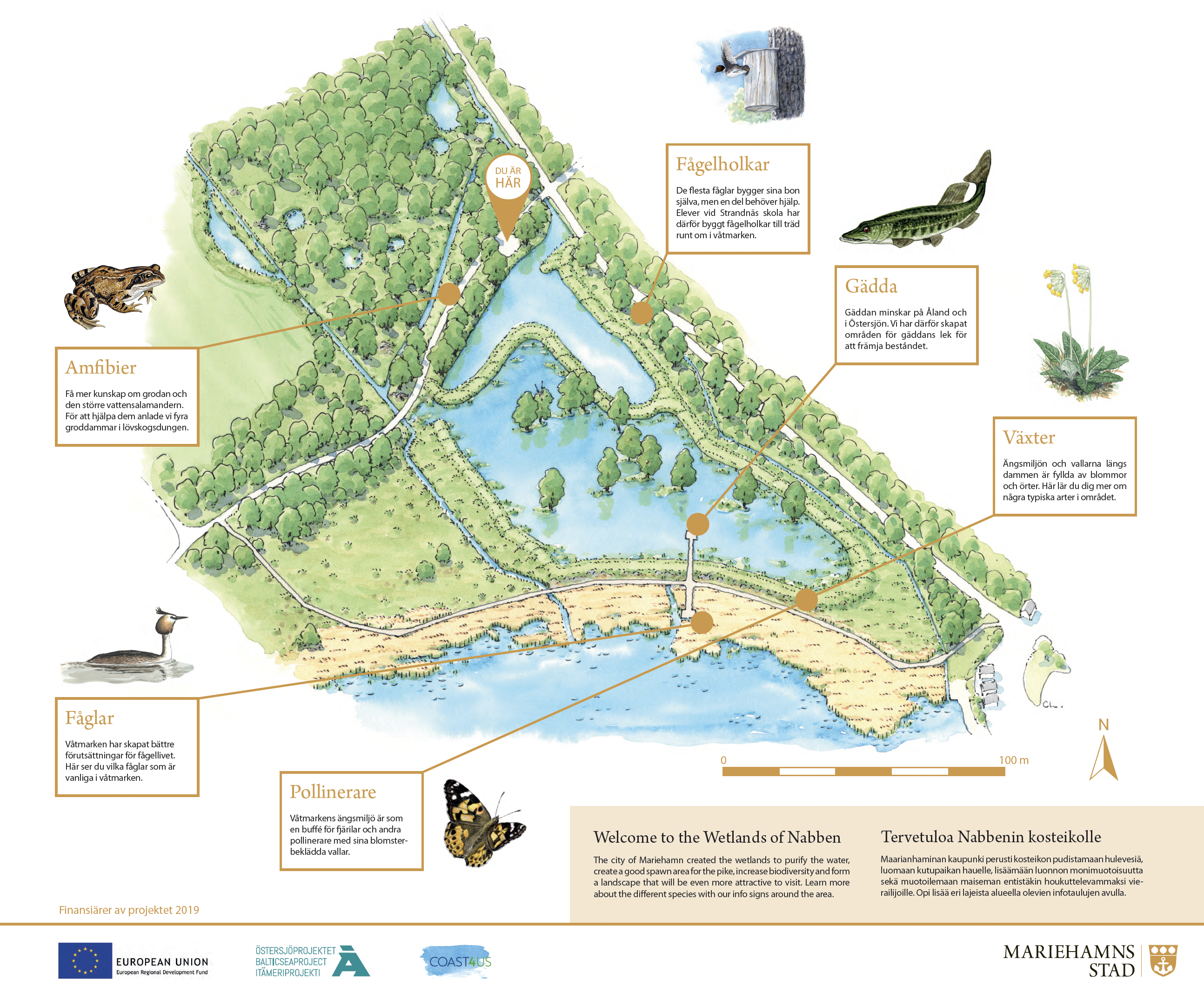
Figure 2 Map over Nabben, with educational information. (mariehamn.ax 2024)
Besides its obvious benefit in purifying storm water before it enters the Baltics, the wetland protects against storm surges. To increase the recreational and education values of Nabben, there are walkways in and around the surrounding park. Further, there are information boards explaining both the water purification as well as its biodiversity in and around the park surrounding the wetland.
To help the aquatic fauna in the Slemmern, 10,000 juvenile pikes were released in the wetland. Since pikes are territorial, some of them are expected to come back to reproduce, further increasing the biodiversity.
The rich fauna in and around the wetland also generates social benefits in terms of increased biodiversity in the area.
Existing CBA
To our knowledge no initial cost benefit analysis was conducted as a part of the decision to build the wetland and its connecting streams and sediment pond.
Specific Societal Challenges addressed
Climate change mitigation and adaptation; Disaster risk reduction; Environmental degradation and biodiversity loss; Human health; Water security.
Sweden
Flood protection in Getinge
Description
The village of Getinge, located in Halland in southern Sweden, has experienced repeated flooding due to increased water flow in the Suseån River. To address this issue and protect critical infrastructure, the municipality of Halmstad initiated an investigation into the feasibility of implementing a nature-based solution. As part of the effort, a Cost-Benefit Analysis (CBA) of direct costs and benefits was conducted.
The flood protection system, shown in Figure 2, consists of two embankments (marked in red) with a total length of 1.2 km. These embankments, constructed using clay, soil and sand, protect key infrastructure in the village. The red-shaded areas represent zones at risk of flooding before the embankments were built, while the purple area indicates the reduced flood zones after construction.
A 16-hectare wetland was also established between the embankments. During normal water levels, runoff from nearby agricultural fields flow directly into the river. However, during high water events, gates are closed to retain water within the wetland, reducing downstream flood risks. The wetland also serves as a buffer zone, capturing excess nutrients from agricultural runoff and supporting local biodiversity.
The project also incorporates educational and recreational benefits. Walkways were built around the wetland to provide residents with opportunities for recreation, and educational research stations were established to engage schoolchildren in learning about local ecosystems and water management.

Figure 3 Map over Flood protection in Getinge, where the red striped line symbolises the sand banks, the shaded red colour symbolises the previous flooded areas and the shaded purple colour symbolise the areas that will be partially flooded after the sand banks are built.
Existing CBA
The decision to build the sand banks was preceded by a CBA that took direct costs and direct savings from reduced damages on strategic infra-structure into consideration. The CBA used a project lifetime of 83 years and social discount rates of -3.5, as well as with 1.4 percent p.a. were applied when calculating the net present value. Both discount rates gave a positive net present value; 1 and 10 MSEK for 1.4 and 3.5%, respectively.
Identified positive externalities
Since the runoff from the surrounding agricultural areas into the river is being slowed down, a regulating ES effect is the removal of Nitrogen (500–1000 kg/ha) and Phosphorus 50–100 kg/ha from the river that would otherwise have increased the eutrophication of the sea. (Weisner, Johannesson, and Tonderski 2015). A wetland of this size can also be estimated to sequester 30–200 tons of CO2. Another benefit from the project is the positive impact on the supporting ES of habitat provision since the areas directly outside of the sand banks are being transformed into wetlands and thereby increase the biodiversity in the area. Further, the areas in and around the sand banks increase cultural ES in the form of recreation for people living nearby, as well as educational purposes for nearby schools.
Specific Societal Challenges addressed
Climate change mitigation and adaptation; Disaster risk reduction; Environmental degradation and biodiversity loss; Human health; Water security.
Norway
Flood able park (retention basin) in Nesbyen, Norway
Description
Due to increased flood risk along the Hallingdal River in Nesbyen, Norway, the village has experienced regular flooding incidents, impacting local infrastructure and agricultural areas. In response, the municipality of Nesbyen has designed a nature-based solution to mitigate these floods through the construction of a "floodable park". The project includes constructing soil banks, a retention basin, and a floodplain area spanning just under one hectare which serve as water retention and storage during high-flow periods. Additionally, the floodplain area provides a seasonal wetland that supports biodiversity and habitat formation, enhancing the ecological value of the area.
During typical river flow, water freely flows through channels in the park, allowing nearby agricultural runoff to enter the floodplain for natural filtration. In high-flow events, the floodplain holds excess water, which is gradually released after flood peaks, reducing downstream pressure and safeguarding infrastructure.

Figure 4 Retention basin, Nesbyen Norway
Existing CBA
A simplified Cost-Benefit Analysis (CBA) and risk assessment for Nesbyen’s floodable park project has been conducted, focusing exclusively on reduced damages to residential houses, commercial businesses, and apartment buildings in the event of a 200-year flood. This CBA spans a 100-year analysis period with a declining discount rate (4%, 3%, 2%)
4% for the first 40 years, 3% until year 75 and 2% for following years. Common Norwegian practice.
Importantly, this CBA does not account for potential cost savings from less severe, more frequent flooding events, which are also likely to be reduced due to the flood park’s protective infrastructure. By excluding the benefits of mitigating these lesser flood events, the analysis may underestimate the park's economic benefits. More frequent flooding incidents can cumulatively contribute to severe damage over time, impacting infrastructure stability, community displacement, and ongoing repair costs for local municipalities. Including these additional benefits in future analyses could improve the project's financial outlook and potentially highlight greater long-term savings.
The Norwegian Water Resources and Energy Directorate (NVE) is conducting a more thorough investigation into the flooding dynamics of the area, including an assessment of the severity of flooding events of different frequency. However, the results of this study were not available at the time of this report’s publication.

Figure 5 Simulation of 200-year flood, where the left pane shows the simulation without the measure, and the right pane shows the simulation with the measure.
Identified positive externalities
The park contributes to water purification by filtering runoff from nearby agricultural areas, which reduces the levels of nutrients like nitrogen and phosphorus entering the river and helps maintain better water quality. It also aids in disturbance regulation by acting as a flood buffer, holding back excess water during high-flow events and reducing flood risks for surrounding areas.
The park provides recreational opportunities through pathways and observation points, allowing the local population and visitors to engage in outdoor activities and connect with the natural landscape. It also supports science and education, serving as a learning site for schools and researchers interested in ecological processes, water management, and nature-based solutions. The park also contributes to public health and well-being by offering a natural space for residents, which can have positive effects on mental health and overall quality of life.
The park supports nutrient cycling by capturing agricultural runoff, which contributes to a healthier river ecosystem through natural nutrient processing. The floodplain creates habitat provision in the form of seasonal wetlands, supporting local biodiversity and attracting various species. Additionally, by slowing the entry of pollutants into the river, the park helps maintain water quality over time.
Specific Societal Challenges addressed
Climate change mitigation and adaptation; Disaster risk reduction; Environmental degradation and biodiversity loss; Human health; Water security.
Stream daylighting of Hovin Stream, Oslo
Description
The daylighting of Hovinbekken, a stream in Oslo, involves gradually reopening its previously enclosed sections to restore its natural flow and bring ecological, recreational, and environmental benefits to urban areas. The project has transformed Hovinbekken from being around 70% enclosed to almost 70% open, following a multi-decade process of strategic daylighting along various sections of the stream. The stream originates in Lillomarka near Linderudkollen and converges with the Akerselva under Oslo Central Station.
The daylighting efforts at Hovinbekken have included several notable stretches, such as:
- Årvoll pond: A section where the stream now flows through a pond.
- Bjerkedalen Park: A significant park feature incorporating the stream.
- Teglverk pond at Hasle: Opened in 2015, this stretch has become a popular spot with naturalistic design elements.
- Ensjø and Jordal: Ensjø is an area undergoing transformation from industrial to residential, allowing for open water spaces and integration with urban development. The segment at Jordal was reopened in 2020.
The project aims to mimic natural watercourse characteristics as closely as possible. This includes creating varied, meandering paths, vegetative buffers, and even deeper pools for aquatic life, providing shelter for fish and ensuring ecological balance. Additionally, these naturalistic features support flood control by managing urban runoff and increasing infiltration.

Figure 6 Daylighting of Hovin Stream in Oslo, showcasing the transformation of urban spaces with new green areas like The Teglverk Dam, The Tiedemann Park and The Stårlverk park.
The daylighting of Hovinbekken allows the stream to naturally manage stormwater through a series of open channels, wetlands, and retention areas. By slowing down and absorbing excess water during heavy rainfall, the stream reduces the risk of urban flooding, protecting nearby infrastructure and neighbourhoods. This natural flood management is increasingly crucial as climate change leads to more frequent and intense rain events. Additionally, it lessens the load on Oslo’s drainage systems, potentially reducing the need for costly artificial flood control infrastructure.
Existing CBA
To our knowledge no initial CBA has been conducted.
Identified positive externalities
Climate Regulation
Exposing Hovinbekken and integrating it into green spaces creates microclimates that help mitigate the urban heat island effect. Water from the stream evaporates, cooling the surrounding air, especially during warmer months. The vegetation along the stream also provides shade and further cools the area. This natural cooling reduces the need for energy-intensive air conditioning in nearby buildings, which in turn contributes to lower greenhouse gas emissions. The green corridor along Hovinbekken thus supports both local climate comfort and broader climate goals for Oslo.
Recreation
The daylighted Hovinbekken offers a scenic, accessible environment for recreational activities. Parks, pathways, and open areas along the stream are popular spots for walking, jogging, picnicking, and other outdoor activities. These green spaces enhance physical and mental well-being for residents, providing a natural retreat within the urban environment. Moreover, by creating accessible water features, the project encourages residents to connect with nature and engage in outdoor exercise, fostering a healthier community.
Sense of Place
Daylighting Hovinbekken restores a natural feature that was previously hidden, reconnecting Oslo’s residents with an important part of the city’s ecological and historical heritage. The stream becomes a living reminder of Oslo's natural landscape, creating a unique urban identity rooted in environmental stewardship. By bringing nature into the city, the project strengthens residents’ connection to their environment and enhances community pride. This sense of place is invaluable in cultivating a collective responsibility for Oslo’s green spaces and waterways.
Specific Societal Challenges addressed
Climate change mitigation and adaptation; Environmental degradation and biodiversity loss; Human health.
Denmark
Climate adaptation at Karens Minde
Description
The cloudburst and urban space project Karens Minde Axis in the Copenhagen area of Sydhavn combines retention of up to 15,000 m3 of rainwater with the development of parks, urban spaces, and nature. A tiled path wavers like a yellow river in and out between the many large old trees in the area. In the event of a cloudburst, water is transported through a 600 meters long course from Ellebjergvej in the north, past Karens Minde Culture House, and finally collected in a recreational rainwater basin.

Figure 7 Karens Minde, Copenhagen Denmark. The green areas symbolise the implemented park and the included rainwater retention
The project aims to improve the physical framework of the positive development that Sydhavnen is undergoing, where a unique grassroots spirit is paired with culture, nature, and wildlife. In the future, a large part of the area’s cultural life, social activities and everyday life will unfold in the Karens Minde Axis, which at the same time creates a green connection between Vestre Kirkegård in the north and Tippen in the south. The project was constructed in 2023.

Figure 8 Karens Minde, Copenhagen Denmark
Existing CBA
For both the Danish projects in this report, a CBA has been conducted for the entire municipality of Copenhagen, but not for sub-projects. The results show a net present value of approx. DKK 5 billion. In the CBA, the following benefit components in terms of avoided damages are included: Damage to buildings and infrastructure, clean-up, traffic delays, lost earnings, and production loss.
Identified positive externalities
The Karens Minde project is part of Copenhagen municipality's cloudburst program which aims to reduce damage during cloudbursts. In addition to reducing damage during cloudbursts, the project has a positive effect on biodiversity as a recreational pond has been established to store rainwater during cloudbursts, as well as a "trickle meadow" has been established to function as a green cleaning measure. In addition, the facility receives everyday rain from the area, which reduces the amount of overflow water from the common sewer to the harbour, and then improving the environmental condition in the sea. The project has made a large area accessible to the citizens of the neighbourhood and made staying in the area more attractive.
Specific Societal Challenges addressed
Climate change mitigation and adaptation; Environmental degradation and biodiversity loss; Human health.
Climate adaptation at Skt. Kjelds neighbourhood
Description
The vision for Skt. Kjelds Square and Bryggervangen has been to transform the area into the green heart of the Climate-Resilient Neighbourhood, and to make it an urban space where nature is permitted to spread and where traffic operates in fine interaction with recreational areas. At the same time, Skt. Kjelds Square and Bryggervangen have been transformed, so it can protect the entire area from the future increase in precipitation and cloudbursts.

Figure 9 The intersection at Bryggervangen
Photo: Troels Heien

Figure 10 St Kjelds neighbourhood
Existing CBA
As mentioned above, a CBA has been conducted for the entire municipality of Copenhagen, but not for sub-projects. The results show a net present value of approx. DKK 5 billion. In the CBA, the following benefit components in terms of avoided damages, are included: Damage to buildings and infrastructure, clean-up, traffic delays, lost earnings, and production loss.
Identified positive externalities
Before the project began, the project area had around 15,300 m2 of road area and no nearby places where the residents could meet or go for a walk. Now there is only 5,600 m2 of that road area left, and the rest of the area has been transformed into green areas. The transformation of the area means that there are now far more recreational areas including trees, bushes, and plantations and thereby the biodiversity has become much greater. This allows the citizens of the area to have nature experiences close to where they live.
The green basin in the project receives everyday rain from the area, which reduces the amount of overflow water from the common sewer to the harbour. The extensive greening of the area also means that the project helps to reduce the UHI effect. It is estimated that the surface temperature and the temperature in the urban space during heat waves are reduced by 6–8 °C.
Specific Societal Challenges addressed
Climate change mitigation and adaptation; Environmental degradation and biodiversity loss; Human health.