4. Cases from the North Atlantic region
This section presents seven case studies developed by workshop participants, drawing on their own experiences and contexts. Together, the cases ground the report's reflections in the realities of planning practice across the North Atlantic region. They illustrate both the diversity of challenges and the range of opportunities, with each case bringing its own characteristics and dynamics. While the workshop primarily focused on the North Atlantic region, a contribution from England was also included, reflecting the broader relevance of these challenges.
4.1 Local knowledge in Norwegian fisheries management
Background
MSP in Norway is conducted through two main procedures. In coastal waters and in fjords, planning is regulated under the Planning and Building Act and implemented at the municipal and regional levels. All municipalities with coastlines have marine spatial plans. Offshore, different sectoral agencies are responsible for three management plans for the Barents Sea, the Norwegian Sea and the North Sea/Skagerrak, respectively. In addition, in the open ocean, sectoral agencies allocate licences within their respective sectors, such as energy (including oil and gas and offshore wind) and open ocean aquaculture.
Competition for marine space is big and growing. Different interests increase the demand for space, alongside heightened attention to the need for marine protection. In addition, new users and interests are emerging such as carbon storage, mineral exploitation, offshore wind and nature conservation.
Traditional use of the sea is characterised by informal practices and traditions. Ocean space has been shared among multiple users, for limited time periods, with their use leaving no visible traces. Provided there is sufficient marine space, this informal system functions effectively. However, over time, there has been a growing shift from multiple use to singular use. When this occurs, newly established rights gradually displace traditional access to the commons.
Traditionally, fishers have often been suspicious about giving out information about key fishing areas. Some still are, because they want to keep this information secret to prevent others from “poaching” in these locations. However, as vessel monitoring systems have become more openly accessible, along with increased competition for space, there is now wider acceptance for sharing such information.
Good and robust knowledge of how the sea is utilised is needed to allocate space, not only for static locations such as offshore installations, but also to ensure that more dynamic marine uses, such as important fishing areas and spawning/juvenile areas, are taken into account at an early stage in the planning process.
In Norway, the Directorate of Fisheries has been collecting fisheries data since the 1980s, through structured interviews with local informants. These data have been digitalised and are available through the Directorate’s mapping site “Yggdrasil”. The directorate is also invited to contribute to spatial plans at the local, regional and national level.
The tracking of fishing vessels has become an increasingly valuable tool, with both Vessel Monitoring Systems (VMS) and Automatic Identification System (AIS) data making data collection more robust. However, the mere tracking of vessel movements alone is not sufficient: there is also a need to understand and highlight the dynamics of fishing operations, and fluctuations in fish stocks, quotas and market demands. Both methods are currently being used by the Directorate of Fisheries.
Problem description
In contrast to energy installations, shipping corridors, aquaculture etc., fisheries represent interests that are not tied to specific locations. In MSP, interests that can be spatially defined through geographic polygons are digitalised and mapped. As more interest areas are incorporated, activities not bound to specific locations end up being excluded based on the argument that alternative areas are available for these interests. However, if these interests are continually displaced to new locations, there will ultimately be no place left for them. There is therefore a need to place particular emphasis on the spatial requirements of fisheries and living marine resources within MSP, including visualisation of these interests and making mapped data more robust.
In recent years, there has been a tendency for some fish stocks to increase in abundance due to climate change, while others have declined. We expect these changes to continue and likely intensify in the coming years. Those who work at sea are often among the first to observe such changes and can provide valuable insights. However, there is a risk that such knowledge may be mis-interpreted, leading to reluctance to share the information and resulting in knowledge remaining with those who hold it, only to be lost. For instance, if certain species disappear from an area due to climate change and nutrient loading, it would be incorrect to conclude that overfishing is the culprit.
What was done
Conducting interviews with fishers is time-consuming. One lesson learned is that, in many cases, interview data from the 1980s remained valid when new interviews were carried out 20 years later. Tracking data from AIS and VMS have also shown comparable results, which means that the interview method is reliable. Today, interviews are therefore supplemented with other data sources, such as tracking data from VMS and AIS, as well as catch data from electronic logbooks (ERS).
A key advantage of tracking data is that they are numeric, enabling more accurate calculations, such as the number of fishing operations in a given area, volume of catch and species caught. Furthermore, it is worth noting that many seasonal fisheries take place in distant waters. Those who operate in these areas possess detailed, location-specific knowledge that is not captured by local interviews.
Reflections through a justice and equity lens
Lessons learned from Norway show that it matters who collects and communicates fisheries data. In the worst-case scenario, information can be misinterpreted and used against those who provided the data. Strong competence among the facilitators is therefore needed to build trust. Establishing and maintaining such trust requires time and specialist skills. It has taken many years to build up a methodology that is trusted by fishers and sufficiently robust to provide reliable numerical data.
However, there is ongoing discussion about what is the best way of communicating fishing interests. So far, fishing operations have been considered a useful indicator. If catch volumes or values of catch, for instance, were used instead, this would introduce bias towards large vessels, in particular towards pelagic fisheries, which typically catch large volumes. As a result, insufficient consideration might be given to small-scale, local fishers, who have limited access to secondary fishing grounds and depend on short distance to landing sites.
Lessons learned and recommendations
Interviews combined with tracking data have proven to be valuable and powerful tools for identifying and visualising local knowledge. The addition of VMS, AIS and ERS data enhances information on fishing operations, catch volumes and species, creating opportunities for more robust analyses. However, it is very important to ensure that those collecting and interpreting the data have a strong understanding of the users, as data can easily be misinterpreted and even misused.
A structured and systematic methodology should be created and tested prior to data collection. Without this, data cannot be compared, built upon on in an iterative process or replicated at a later stage. Weaknesses and gaps in data collection should be highlighted – for example, recreational fishing, which is poorly documented in Norway. AI is currently being used to support information gathering on planning processes, interests expressed by different users and reporting. Good GIS skills are also necessary. The “Yggdrasil” mapping platform of the Directorate of Fisheries illustrates how this is implemented in Norway.
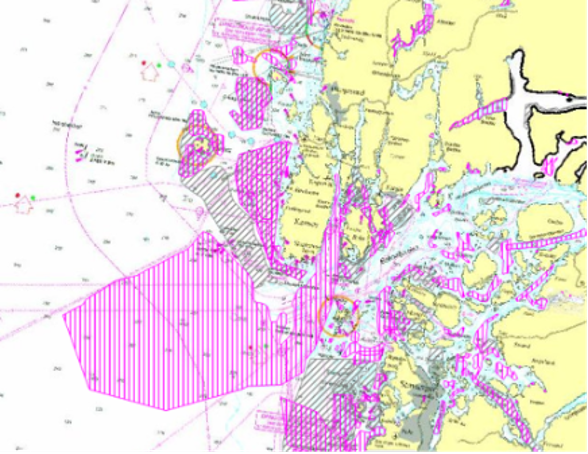
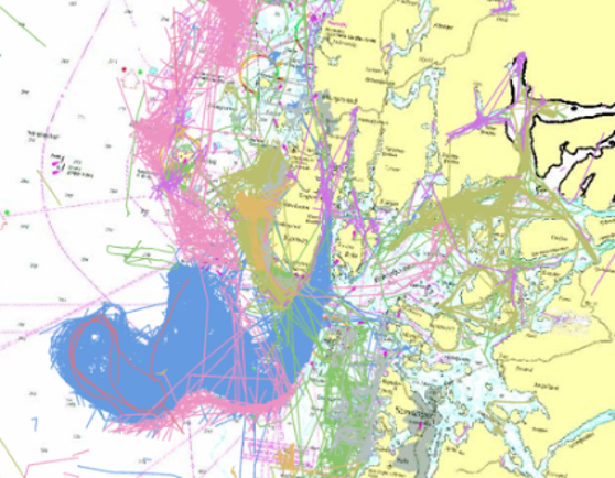
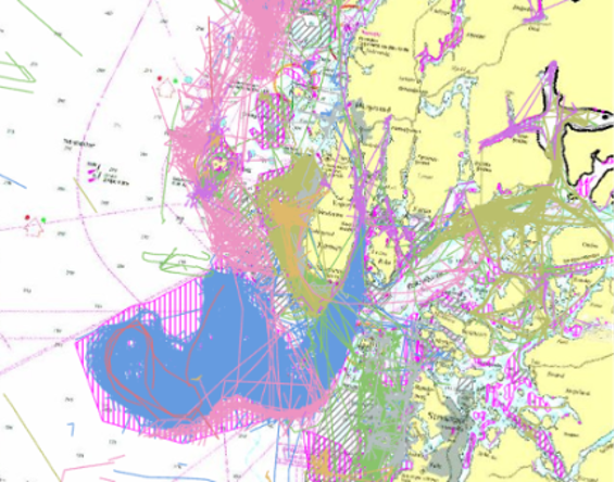
Below are three maps presenting fisheries data: the first is based solely on interviews, the second shows tracking data only and the third illustrates the overlap between interviews and tracking data.
All maps are from Yggdrasil, the Norwegian Directorate of Fisheries' visual mapping platform. For more information, see https://open-data-fiskeridirektoratet-fiskeridir.hub.arcgis.com/
4.2 Marine decision-making in Portsmouth, England
Background
Southsea is located on the south coast of England and is a suburb of the City of Portsmouth. Portsmouth has a long maritime history, and its natural harbours are still used for transportation and military activities.
The Southsea Coastal Management Scheme was developed to address the policy decision to “hold the line” in response to coastal change in Southsea, Portsmouth, England. This decision, set out in the regional Shoreline Management Plan published in 2010, provided the basis for designing a new sea wall to protect the Southsea area from increasing sea levels and storm surges.
The main stakeholders in the case were local residents and business owners in Southsea. Local knowledge mattered in this case study due to the long cultural maritime heritage of the area, as well as the size of this coastal defence project, effectively changing the physical relationship between the suburb and the sea.
Problem description
The decision to develop a new sea defence for Southsea was made outside of the MSP/marine management decision-making process. While Southsea benefited from this decision, other areas along the UK coast did not, due to limited funding available and the practicalities of protecting the entire coastline.
The Shoreline Management Plan did not include public consultation. Consultation was therefore limited to the design of the sea defence rather than whether it was needed (or wanted).
The project was subject to “dual consenting”. It required both a marine licence and planning permission to be constructed. This led to some confusion between what consultation was taking place at which stage and the scope of the consultation.
What was done
The city council, district council and developer partnership undertook extemporary public engagement during the design stages pre-consent. Much of this engagement was “non-statutory” and aimed at providing local people with the opportunity to view and comment on the short list of coastal defence options. It was clear that the public were interested in the scheme due to the 378 public responses received during early consultations.
In the lead-up to submission of the planning application, the developer partnership ran an additional series of three non-statutory consultation exercises. The first reintroduced the scheme to local people. The second invited local input on elements of the design. The third was used to understand public opinion about the final design.
As noted above, this scheme required both planning permission and a marine licence, representing two separate regulatory decisions made by two separate organisations: (Portsmouth City Council (as the local planning authority) and the Marine Management Organisation (as the marine regulator for England). The English Coastal Concordat was used to allow Portsmouth City Council to “lead” the regulatory processes to avoid double working and to simplify the decision-making process for stakeholders. This approach was particularly relevant for the required Environmental Impact Assessment, for which Portsmouth City Council took regulatory lead and the Marine Management Organisation “deferred” to the Council’s decision.
Reflections through a justice and equity lens
At the local level, this example provides best practice in relation to trust, legitimacy and acceptance through the enhanced consultation process. However, the case also raises the challenge of balancing local and national needs. While Southsea benefitted from the Shoreline Management Plan process, other areas may need to be ‘sacrificed’ to direct funding towards areas assessed as most in need or of greatest value. How decisions about which areas of the coast to protect in a changing climate are made require careful consideration of justice. In the Southsea example, there is a clear need to protect the residential properties along the coast due to the number of people impacted. However, this utilitarian response to climate change induced by coastal change may not apply with longevity, and questions about cost also need to be considered.
The time between the original Shoreline Management Plan to the consent decision for this project spanned over ten years. In this time, the local population of Southsea would have inevitably changed. Many of the comments from earlier consultation exercises were seen as “final”, with a “shortlisting” approach taken in the design process. While this made pragmatic sense, it can be questioned as to the legitimacy of later consultations in which only the details of the scheme were discussed. What does this mean for new residents or new stakeholders?
Our case example followed the decision-making process up to the consenting of the Southsea scheme. It did not consider post-consent processes or the construction of the project. While engagement has continued between the developer and the local community post-consent, there is little incentive to maintain such engagement within the English marine regulatory framework.
Lessons learned and recommendations
This case provides a strong example of how to undertake local level pre-consent consultation and engagement. The enhanced engagement activities did allow for local residents to express their views. However, the duration of the design process raises challenging questions about how to include comments from “new” stakeholders later in the process. In the Southsea example, this was managed relatively well through a public-facing website designed to provide all background information on previous public engagement and the timeline of design development. Nonetheless, the long timescales involved in pre-consent project design raise wider questions of justice. There appears to be a tacit belief that stakeholder groups remain the same throughout project development – clearly not realistic given changing members of design teams. It could be argued that for “new locals” moving to areas where coastal projects are being developed, their personal due diligence prior to entering the local area should alert them to ongoing local developments. However, this does not appear realistic. While UK property conveyancing for a house purchase may flag ongoing planning matters impacting the property, this depends on the level of searches undertaken and a judgement call by the solicitor about what to include. Moreover, this also does not apply to rental properties, to which conveyancing law does not apply.
Key insights from Southsea are:
- Engage early, engage often and ensure that previous design decisions are publicly accessible through online records and local area advertising. This helps to inform “new locals” of developments in their area and mitigates the risk of settled design matters being “reopened” later in the process.
- Where appropriate, streamline complex decision-making processes through deferral agreements between consenting bodies.
- Consider the relationship between local and national interests and communicate this appropriately. Reflect on how decisions made to protect one locality may have impacts on other areas, sometimes located at a considerable distance from the decision area.
4.3 Sullom Voe Master Plan, Shetland Islands
Background
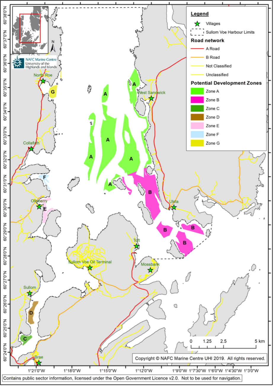
Sullom Voe Harbour, operated by Shetland Islands Council (SIC), is home to Europe’s largest oil terminal, currently operated by the energy company EnQuest. It receives crude oil and natural gas from offshore fields via pipelines, processes it and then exports it globally by tanker. The terminal serves as a crucial processing and storage hub, connecting offshore production to the global market and playing a significant economic role in the region. Peak throughput at the terminal occurred in the mid-1980s and has been steadily declining since.
For navigation and safety reasons, the SIC has, as a matter of policy, restricted aquaculture development in Sullom Voe Harbour Area. This policy was to be reviewed when tanker movements dropped to less than 50% of peak levels. With a decline in tanker movements in 2018, the SIC initiated a review of this policy, with the aim of creating a master plan for the harbour area. Central to this process was the collection of information on development constraints and opportunities from the local community and stakeholders. The Master Planning process was led by the NAFC Marine Centre UHI (now called UHI Shetland).
The Sullom Voe Master Plan draws upon the data and policy framework provided by the Shetland Islands Regional Marine Plan (SIRMP). The SIRMP is a statutory sub-national plan, with marine planning in Scotland governed by the Marine (Scotland) Act 2011. The Sullom Voe Master Plan was intended to provide more detailed spatial guidance for licensing and leasing within the harbour area.
Problem description
Three options were presented for the Sullom Voe Harbour area: (1) retain restrictions relating to aquaculture, (2) expand restrictions to include all activities involving surface works (e.g. expand to include seaweed cultivation), (3) allow aquaculture development to occur in Sullom Voe and provide spatial guidance on where this would be appropriate. The aims of the public engagement process were to:
- test the existing policy landscape and assess if it is fit for purpose
- assess the level of interest in future development of the area
- ensure that the community and relevant stakeholders have a meaningful opportunity to contribute to the master plan
- gather fresh information about opportunities and constraints
- identify community priorities that should inform future development decisions.
The initial SIRMP provided a baseline data assessment. Local communities had previously been involved in checking the accuracy of national data sets, identifying gaps, providing information on community use and helping to prioritise data collection. While data collected to inform the SIRMP were substantially more detailed than national equivalents, the development of the master plan required further detailed fisheries data collection, understanding of community use and community views on the future use of the harbour.
Determining the relative weight to assign to different considerations was a particular challenge, with a number of international designations and navigational considerations, for which the Harbor Master held legal responsibility. These considerations made the area “legally congested” despite the expansive nature of the harbour.
What was done
A two-phase public engagement process was undertaken to gather community views, map important community features and existing data held within the SIRMP. Face-to-face orientation meetings were held with key stakeholders, alongside four public community events designed to capture views and knowledge held by the community. In addition, an online survey was made available to allow more people to engage in the process and for further insights to be gathered.
Feedback from the community indicated widespread support for exploring new potential uses within the harbour area, enhancing potential employment opportunities in a rural area. Subsequently, the mapped data were used to identify potential suitable locations for future development. Feedback from phase 1 also included additions to the initial maps and other suggested data. All data were then categorised into either “Excluded from Search” or “Potentially Excluded from Search”, based on the level of policy or legal protection associated with the data type.
All data classified as “Excluded from Search” were combined to create Potential Development Zones. These data, along with the resulting zones, were presented during the second round of public engagement. Feedback from those events was then incorporated into the final version of the Potential Development Zones.
Data collected included information on recreation, community use and value. Dedicated meetings were held with the fisheries sector and fishers were contacted individually. Detailed inshore fisheries data were collected through a multi-stage mapping and verification process. Data ownership remained with the fishers, allowing them to quality check outputs, control how their data were used, agree on an appropriate level of granulation that retained a level of confidentiality while providing an informative data set, and withdraw consent if they wished. Different mapping approaches were used for each segment to reflect nuanced differences between them.
Reflections through a justice and equity lens
The master plan process did not have a predetermined outcome, and the capacity for the community and stakeholders to genuinely influence the outcome supported both procedural and recognitional justice. However, national considerations, such as Special Areas of Conservation (SACs), carried substantial legal weight and constrained where development could occur, predetermining a degree of distributive justice. As these designations were non-negotiable in this process, and as they covered large areas, it effectively meant that once the community agreed to explore development options, the capacity to influence where development could take place was limited.
Considerable attention was given to determining the appropriate weight to assign to fisher and community activities. Given the rural locality, recreational use may occur in areas used by one or two people, while fishing grounds may be associated with individual part-time fishers. This contrasted with the potential for a new aquaculture site to provide multiple high-value, full-time jobs. Balancing existing uses against future impacts and benefits is particularly challenging.
Lessons learned and recommendations
Despite the Sullom Voe Harbour area being expansive and relatively unused, navigation and natural heritage designations restrict future development opportunities and subsequently limit the capacity for local communities to meaningfully influence where development takes place, highlighting the trade-off between national and local interests. By sharing the available mapped data and information at the initial meetings it allowed for a degree of expectation management, ensuring communities were aware of the types of considerations that would inform spatial mapping.
Local communities may be reluctant to provide data where there is no trust established, leading to exclusion from processes. Mapping does not often allow for context, such as onshore dependency and the impacts of losing fishing grounds on local communities – including the sustainability of upstream and down-stream industries (e.g. ferries) and the potential impact on school enrolment. Decision-making detached from this context can therefore be problematic. In this case, these challenges were addressed by ensuring that these concerns were considered and shaped subsequent mapping and digitisation processes.
4.4 Participatory mapping towards stricter protection in a Norwegian marine national park
Background
This case study focuses on knowledge and participation in the process for stricter protection of the marine environment in Raet Marine National Park (MNP), established in 2016. Of the park’s total area of 607 km2, 98% of is marine and 2% is terrestrial (Raet Nasjonalpark, 2025). It is located on the south Norwegian Skagerrak coast, a densely populated region with a predominantly rocky shoreline interspersed with natural beaches, bays, inlets and urban sprawls. The seascape is characterised by characteristic skerries and small, dotted islands, shaped by end-moraine deposits from the last ice age (from which the name “Raet” is derived).
Access to the Skagerrak Sea has supported and sustained livelihoods far beyond its geography through centuries of marine harvesting, trade and communication between Norway and the European continent. The seascape is used in a wide variety of ways by numerous public, commercial and civil-sector actors. The combination of marine resource harvesting, built-up land expansion and climate change has however resulted in a deterioration of the marine ecosystems, with a deterioration of several species listed under the Convention for the Protection of the Marine Environment of the North-East Atlantic (OSPAR Convention), along with commercially and culturally valued species such as cod, lobster and shrimp (Frigstad et al., 2023; Kleiven & Moland, 2022; Moland et al., 2021; Moy & Christie, 2012). As national and regional policies are set on economic development through “blue growth” from fishing, tourism and shipping, as well as from the onshore and offshore energy sector (Norwegian Ministry of Regional Development, 2021; Norwegian Ministry of Trade, Industry and Fisheries, 2021), and below 5% of Norway's marine environment is currently managed through area-based conservation measures (Jørgensen et al., 2021), the government is urged to fulfil national and international commitments on effective and equitably managed marine protected areas by 2030 (Convention on Biological Diversity, 2022; Norwegian Ministry of Climate and Environment, 2021).
MSP context
The Norwegian seas are regulated by regional ocean management plans and do not follow the EU Marine Spatial Planning Directive. Commercial fishing is managed by the Directorate of Fisheries in line with the Marine Resources Act (2009).
Problem description
The process of achieving more effective and stricter conservation of the Norwegian coastal and marine environment is hampered by incoherent (and partly outdated) policy and governance frameworks, as well as knowledge gaps that together hinder effective conservation measures (Eilertsen et al., 2020; Forbé et al., 2024; Hauge & Stokke, 2021; Kvanneid & Sundnes, 2024). This has become acutely apparent in the MNPs. As they encompass both terrestrial and marine coastal environments, MNPs provide a weak tool for area-based management, as it is juxtaposed between multiple management regimes and sectors with conflicting goals and processes.
Effective conservation measures are also hampered by local conflict, both due to a strong cultural tradition of local self-governance, access to the commons, and especially regarding restrictions affecting local shrimp-trawling and the small-scale fishing fleet (Agderposten, 2021; Fædrelandsvennen, 2021; Iversen & Braathen, 2025).
What was done
Originating from local concern over the highly valued but rapidly diminishing coastal cod, a bottom-up initiative aimed at stricter protection was formalised as the project “Bevar Raet” (Protect Raet) in 2020. The project is hosted by the Agder County Council and led by a core working group consisting of Agder County Council, the MPA manager and the Marine Research Institute (IMR). There is also an established working group with key stakeholders and an advisory committee of marine experts. The groups meet regularly, with the intention of finding ways to protect Raet in collaboration with the local community and the key stakeholders. Towards this end, IMR initiated a co-definition mapping project together with Bevar Raet in 2024, testing the Public Participation GIS “SeaSketch” to co-define no-take areas within the park (Kleiven et al., 2024; Raet Nasjonalpark, 2023). SeaSketch is a software tool that allows users to draw and rank areas of value on a map, using predefined categories that indicate the activity providing the value, such as “commercial fishing”, “diving” or “recreation”. The map is online, shareable and open to all. Researchers can then import and layer this map with other GIS maps to identify conflict-prone areas and practices and test various trade-off scenarios.
Lessons learned and recommendations
The mapping initiative has attracted the attention of local politicians, as well as heightening awareness among local citizens. However, as this process is still ongoing at the time of writing, the following reflections and recommendations are only preliminary.
Distributional and restorative justice
Implementing regulations that restrict the use of resources belonging to the “commons” will inevitably create “winners” and “losers”. In this case, the “losers” are the local, small-scale fishers. Commercial fishers are duly represented in the Bevar Raet working group, as well as in the PPGIS mapping effort, as fishing was pre-identified by IMR as one of the main pressures on the park’s ecosystem. During the mapping process, IMR actively reached out via the working group and through individual contacts, offering guidance and helped to fill in the online maps. However, while fishers were asked to disclose information that could potentially disadvantage them in the future, there has been little discussion about what the fishers stand to lose, beyond its economic value, fishing is also a cultural tradition and lived experience, or discussions on how they could be compensated for that loss.
Procedural justice
While MNPs as an area-based management tool is subjected to a complex macro-structure (for reasons stated above), the composition and management structure of Bevar Raet is complex, and its mandate is unclear. With multiple levels of governance, a political steering group, a project group, a working group and a resource/advisory group, transparency in decision-making is limited. Considering that local fishers have low “process literacy”, they cannot be expected to make demands on behalf of their own rights to information, collaboration or agency in the process. Additionally, Bevar Raet is a project and has no formal mandate to make decisions on behalf of the park. Regardless of the outcome of the PPGIS, fishers’ risk having little impact on decisions regarding whether, how, when and if stricter conservation measures will be implemented in the park.
Epistemic and recognitional justice
The composition of stakeholders in Bevar Raet lean towards a preference for local public sector administrative bodies, academic experts and local fishers. This may exclude other voices and interests, such as local young people, local recreational users of the area, as well as important commercial stakeholders from sectors such as tourism, shipping/ports and aquaculture.
Additionally, the scientific knowledge underpinning decision-making has, until recently, been dominated by marine experts at IMR. As a state-funded institution closely affiliated with the Norwegian Directorate of Fisheries, its research is predominantly oriented towards the use and conservation of marine and coastal values as economic or ecological resources. The traditional maps (Naturbase) and scientific methods and systems (Natur i Norge – NiN) used to define and represent species or habitats of governable value draw on predefined, scientifically quantifiable parameters. Even though a PPGIS such as SeaSketch allows for inclusion of a broader range of stakeholders (and values) in the mapping and zoning processes, a lack of local, practical or experiential knowledge can result in zoning measures that fail to protect areas rich in biodiversity or with high cultural or immaterial value, which is not easily quantified (Kvanneid & Sundnes, 2024; Pascual et al., 2023).
Recommendations
Participation in mapping or planning for use or conservation of areas under pressure require:
- attention to which and how marine values gain legitimacy in scientific knowledge production and decision-making processes
- transparency and clarity regarding roles, responsibilities and expectations related to the collaborative mapping process
- consideration of how to include or represent immaterial or cultural values in maps through the collection of empirical data via counter-mapping exercises.
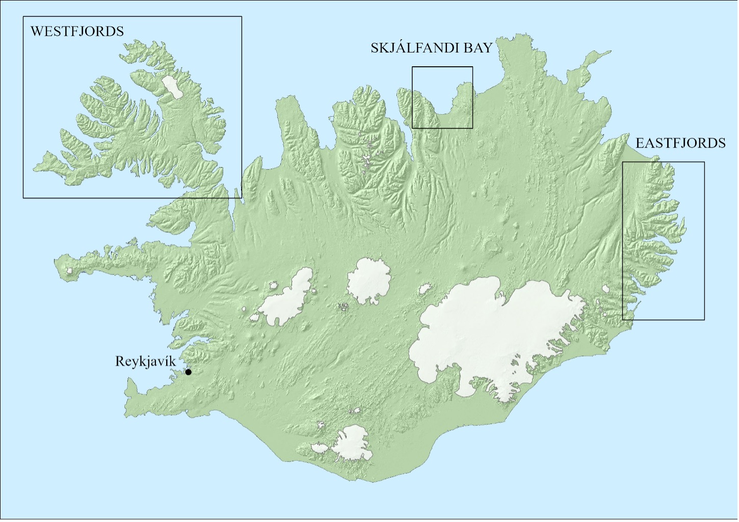
4.5 Marine spatial planning in Iceland
Background
MSP is relatively new in Iceland, with the Law 88/2018 on Coastal and Marine Planning, adopted in 2018, making the national planning agency Skipulagstofnun responsible for MSP outside of municipal limits (beyond 115m from the shore). The Westfjords and Eastfjords were the first regions selected, due to their sheltered fjord coastlines, which support a rapidly expanding aquaculture industry (Wilke & Kristjánsdóttir, 2023).
The Icelandic fjords are vulnerable environments that are already experiencing the effects of climate change. The Westfjords of Iceland have warmed significantly since 2001, with increased winter temperatures and higher precipitation. These changes have led to glacial retreat, shifts in fish stocks, pressure on seabirds and Arctic foxes, and higher risk of avalanches and landslides, which pose a threat to local communities (Bannan et al., 2022).
For the MSP process, regional councils and local consultative groups were appointed to draft the plans and stakeholders such as the Marine and Freshwater Research Institute (Hafro) were asked to provide expertise in the collection of spatial data (Wilke, 2023).
It is important to include local knowledge in processes like this because the communities in these places are small and remote and have made a living in a harsh corner of Iceland for centuries, all the while amassing valuable local knowledge about the coast, the sea and the surroundings that often lack baseline research data. Furthermore, MSP is likely to be more accepted by the public if they are involved early and meaningfully in the process (Pomeroy & Douvere, 2008).
Problem description
Local knowledge has been largely absent from the Icelandic MSP process. Members of the public and citizen groups were asked to comment on already established plans in few and unfortunately timed public meetings (overlapping with the summer holidays). There has been no sustained, iterative communication between planners and local communities. Rather than being invited to participate in the process itself, communities have been asked to comment after the main decisions had already been made. The process failed to recognise existing injustices and power imbalances. Stakeholder meetings served primarily as data collection exercises, rather than opportunities for future visioning, shared objective setting or discussion of conflicts of interest, and were held in separate sectoral groups (Wilke, 2023).
What was done
There are a variety of lessons to be learned from the Icelandic MSP process. In terms of data integration, care was taken to integrate different kinds of expertise into the planning process and to provide a spatial tool for citizens to identify areas they considered important. However, many members of the communities affected by the plans, as well as marine scientists and other experts, were completely unaware of the process until draft plans had already been developed by the planning agency, and the participation tool was only used in the pre-planning phase to gather initial input. Public meetings were held when a draft plan was presented for comments, rather than for visioning, objective setting or keeping locals engaged throughout the process. Stakeholder engagement was limited to a single stage of the gathering of relevant information about the areas used by the relevant actors in the fjords and what they considered important. However, those meetings were held separately in sectoral groups of stakeholders, meaning that no discussion of conflicts took place.
Once the plans had been approved by the Minister for Infrastructure (ministerial jurisdiction over the process changed mid-way through the process after parliamentary elections), they became part of Icelandic law. Initially, the plans did not include an inbuilt clause for review or update, necessitating a ministerial decision to reopen the plans to alter them at a later stage. This has in the meantime been changed, and a less arduous process for updating the plans has been put in place.
At the same time as the plans came into force, a report by the National Audit Office on the lack of regulation of the aquaculture sector was published (Ríkisendurskoðun, 2023) and caused a public and media debate, with criticism directed at the relevant institutions for not having done enough to regulate and hold accountable this rapidly expanding industry (Guðlaugs Drífudóttir, 2023). By extension, the decisions made in the marine spatial plans were also criticised, as they were seen as enabling further expansion without much regulation in place.
Reflections through a justice and equity lens
The Icelandic MSP process presents multiple challenges. As interviews in coastal communities during the MSP process showed, members of the public in the Westfjords were largely unaware that MSP was taking place and voiced distrust towards some decision-makers, including those in their local municipalities, with several mentions of corruption being reported. In the Eastfjords, members of the public mounted a campaign against aquaculture, particularly in the fjord of Seyðisfjörður. Community members wanted their opposition to be acknowledged and reflected in the MSP process and resulting plans, but many felt that their views were ignored or actively dismissed (Wilke, 2023). The campaign to stop fish farming in Seyðisfjörður continue, including multiple social media campaigns and production of a film to highlight the community´s resistance (Garen, 2025; Hannesdóttir, 2025).
The MSP process can be described as predominantly product-oriented, with limited attention to the process itself. There were no clearly articulated participation strategy or criteria as to how stakeholders were selected, and only sparse information on these topics was available on the MSP planning website (Hafskipulag, 2026) during the process.
Public participation in this process can be described as both late and tokenistic. Barriers to participation and to integrating local knowledge into this MSP process arose from both top-down and bottom-up dynamics. From a top-down perspective, these included an exclusionary process directed from the capital city as the centre of power, insufficient transparency, lack of information and a lack of open and explicit communication channels for citizens. From a bottom-up perspective, barriers included a lack of trust in institutions, including local municipalities, prior negative experiences with participation processes in terrestrial planning and a disbelief that community voices would be heard.
Lessons learned and recommendations
The Icelandic MSP process highlights the need for more meaningful involvement, while also pointing to wider challenges related to trust in institutions, power imbalances and limited participation that hinder effective decision-making beyond MSP.
Recommendations include:
- Building trust: Ensure transparency, accountability, shared decision-making and a long-term commitment of time and resources.
- Decentralisation: Share some of the decision-making power. Local actors could lead area-specific planning, later integrated into regional and national plans or other models of decentralisation.
- Process-orientation: Balance the priorities between the process and its outcomes, ensuring fair inclusion in decision-making.
- Participation strategy: Develop a clear engagement plan with objectives, tailored methods, schedules and early, continuous involvement of diverse interest groups and citizens.
- Education and information: Launch education and information campaigns, such as citizen science initiatives, to raise awareness of MSP benefits and marine resources both prior to and throughout the planning process.
- Adaptive management: Embed monitoring, assessment and iterative adaptation into legal MSP requirements.
4.6 Integrating local knowledge into emerging digital marine spatial planning in the Faroe Islands
Background
The Faroe Islands are an autonomous territory within the Kingdom of Denmark, consisting of 18 islands in the North Atlantic and with a population of approximately 55,000. The Faroese economy is highly dependent on the sea, with fisheries and aquaculture industries accounting for more than 90% of goods exports and playing a central role in employment and cultural identity. Small-scale fishing and coastal traditions co-exist alongside industrial fleets and globally competitive aquaculture operations. ILK plays a significant role in Faroese marine life. Coastal fishers rely on generational knowledge of currents, spawning grounds and ecological shifts, while place-based traditions such as grindadráp (community whale drives) illustrate how marine use is embedded in socio-cultural realms (Joensen, 2009). The legitimacy of new governance tools, particularly digital MSP platforms, will depend on how well they reflect and respect this knowledge.
MSP context
The Faroe Islands do not currently have a national MSP. Land planning responsibilities rest with individual municipalities across the Faroe Islands, a situation complicated by the division of responsibility at a municipality level. With 29 municipalities of widely varying sizes, resources and budgets, each act as the local planning authority for its respective area. While statutory planning laws require land-use plans to be made for designated infield areas, this requirement does not extend to outfield or marine areas.
Marine space is increasingly contested. Alongside fisheries and aquaculture, emerging claims include subsea cables, oil and gas exploration, renewable energy projects (including tidal power and potentially offshore wind), tourism and environmental protection – claims which often conflict with local usage, including subsistence and alternative economic practices, and contribute to the increasing privatisation of commons areas (Bogadóttir, 2020).
Problem description
The main challenge in the Faroese case is reconciling existing sectoral marine governance with the need for integrated, digitalised MSP that incorporates ILK. At present, decisions are heavily centralised, with limited opportunities for early community input. Licenses for aquaculture or energy projects are granted based on scientific assessments and environmental standards, but experiential and cultural knowledge is not systematically incorporated, and decisions are often at odds with community interpretations (Hovgaard & Bogadóttir, 2018; Hytönen et al., 2020).
Digitalisation accentuates this gap. GIS platforms, such as kort.foroyakort.fo and online aquaculture maps, provide spatial data for planners and investors. However, these tools primarily rely on standardised datasets, which rarely capture qualitative, place-based insights of fishers and communities and the cultural significance of coastal and marine spaces. The risk is that as MSP becomes more digital, processes will prioritise technocratic efficiency at the expense of legitimacy, recognition and equity.
Furthermore, new industries such as marine renewables or subsea infrastructure will place additional pressure on limited marine space. Without formal MSP, conflicts between aquaculture, fisheries and traditional uses are likely to intensify. If ILK is not integrated, communities may perceive decisions as imposed, undermining trust in governance and reshaping relationships between people and the marine environment.
What was done
While the Faroe Islands do not yet have an MSP framework, several actions demonstrate foundational MSP principles and steps towards integrating ILK and preparing for digitalised planning. These include spatial zoning, ecosystem-based management and adaptive management practices:
Sectoral regulation with spatial dimensions:
Aquaculture licensing and mapping:
Digital mapping portals:
Together, these examples highlight both achievements and limitations. Important spatial data are available, but the integration of ILK remains fragmented and non-institutionalised. Several notable gaps can be observed:
Multi-sector integration:
Authority and governance:
Stakeholder engagement:
Reflections through a justice and equity lens
Examining the Faroese case through an equity and justice framework highlights several key issues:
Legitimacy and trust:
Recognition:
Procedural justice:
Distributive justice:
Reciprocity and cultural context:
Lessons learned and recommendations
The case of the Faroe Islands presents a pivotal opportunity to establish MSP that is just, inclusive and resilient from the outset. Without a national MSP framework, conflicts over marine use between aquaculture, energy, shipping, fisheries and local users will likely intensify, while the absence of meaningful ILK inclusion risks leaving communities marginalised and distrustful. Marine governance that privileges industrial voices over local values undermines legitimacy and weakens trust in a society deeply dependent on the sea.
The Faroese experience demonstrates that the equity-oriented integration of ILK is not only desirable but essential in highly marine-dependent societies. Embedding ILK alongside scientific and sectoral expertise ensures that planning better reflects cultural ties, lived experiences and ecological subtleties overlooked in technical models. By prioritising participatory, transparent and adaptive governance, the Faroese Islands have an opportunity to build trust, legitimacy and long-term resilience from the outset, enabling the development of marine governance that truly reflects and serve the communities most connected to the ocean.
4.7 Blue Justice or just blue? – a case study on Greenlandic small-scale fisheries
Background
This case study summarises a previously conducted research study in Greenland, which explored participatory approaches to marine governance and distributive justice in small-scale fisheries.
The study focuses on the contrasting contexts of Nuuk, the capital region, and the rural fishing community of Narsaq in South Greenland. It explores the ongoing transition in marine management, particularly the recent introduction of an Individual Transferable Quota (ITQ) system for small-scale and inshore fisheries. While ITQs have been used in industrial fisheries for some time, their extension to small-scale fisheries has sparked concerns related to spatial and distributive justice, as well as incorporation of the participatory process into decision-making.
The study critically examined how this policy shift affects price setting, access to fishing grounds, the role of the market and large fishing companies, and the communication of political decisions, especially to rural and Indigenous communities. Greenland does not currently have an MSP process, which further complicates sectoral coordination, for instance between fisheries and tourism.
Key stakeholders include policymakers (Ministry of Fisheries and Hunting), non-governmental organisations, researchers, the Greenland Institute of Natural Resources, fishing organisations such as Kalaallit Nunaanni Aalisartut Piniartullu Kattuffiat (KNAPK), local fishers, and both public and private fishing companies. New fisheries policies, often modelled on Western, particularly Danish standards, have created systemic barriers for Indigenous and local populations, influencing cultural practices, species access and generational continuity in fishing. Incorporating Indigenous and local knowledge is therefore essential, not only to improve species monitoring and policy relevance, but also to address the socio-cultural injustices created by top-down management approaches.
Problem description
Greenland lacks an MSP process, offering an opportunity to integrate Indigenous and local knowledge from the outset. However, existing marine management and policy decisions are deeply shaped by colonial legacies and Western governance models that have proven ill-suited to Indigenous contexts. These top-down approaches have already resulted in spatial, social and distributive injustices, particularly for rural communities, which often feel excluded, unheard and marginalised in decision-making processes.
Despite their deep-rooted understanding of the marine environment, local communities are rarely engaged in decision-making in ways that are meaningful or reciprocal. Their knowledge is often reduced to logbook entries, which are rarely shared back with communities or made usable for local fishers, creating a one-sided flow of information. The absence of an MSP framework further exacerbates sectoral conflicts, such as between fisheries, tourism and shipping, leaving no platform for coordinated planning or protection.
Communities express the desire to contribute knowledge and to ensure that this knowledge is not lost or excluded by not being made accessible or integrated into digital planning tools. They seek greater autonomy and recognition of their contributions to sustainable marine stewardship. A growing divide between government institutions and local populations stems from a persistent lack of effective communication. If not actively addressed and reconciled, this may deepen distrust and further alienate communities from future marine governance processes.
What was done
This study employed a participatory, place-based approach to explore perceived issues of distributive and spatial justice for small-scale fisheries in Greenland. Additionally, the role of Indigenous and local knowledge in future marine governance in Greenland was examined. The project began with the stakeholder workshop “Future of Arctic Fisheries: Sustainability and Reform”, which was held at the University of Greenland in Nuuk and included representatives from the Ministry of Fisheries and Hunting, the Greenland Institute of Natural Resources (GINR) and Royal Greenland, as well as academic researchers. The workshop introduced the study’s objectives and provided a space for initial dialogue, followed by in-depth interviews with institutional actors.
To ground the research in local realities, extended fieldwork was conducted in the rural fishing community of Narsaq in South Greenland. In collaboration with the local community centre, the researcher participated in the annual Fishers and Hunters Festival (Ukiaanerani Pikialaarfik), organised by Innovation South Greenland, and conducted semi-structured interviews with residents in various settings, including their homes, the harbour and communal spaces, with the assistance of a local translator. These interactions helped capture community perspectives on justice and equity, marine governance, perceptions of government institutions, and desires for greater inclusion in decision-making processes.
Additionally, the study examined how past policies, colonial history and current land-based conflicts (e.g. mining) shape place attachment, identity and trust towards authorities. It also explored where knowledge gaps exist, how local and Indigenous knowledge could be meaningfully integrated into marine planning, and whether institutional stakeholders would support such integration.
Digital tools were examined as a potential bridge, both for knowledge inclusion and for empowering disadvantaged communities such as Narsaq. The research explored how fishers could potentially access and use digital platforms and what support would be required for such tools to be useful in practice. Crucially, the study illuminated a growing disconnect between government institutions and local communities, rooted in differing understandings of marine stewardship and poor communication. If this divide is not addressed, it risks deepening distrust and undermining the long-term legitimacy and success of future marine planning processes.
Lessons learned and recommendations
The study highlights deep-rooted distrust between authorities and local communities, stemming from longstanding exclusion from decision-making processes. Local fishers, in particular, are often positioned as passive recipients of decisions, rather than active participants. This marginalisation is partly linked to colonial path-dependencies and narratives, where decisions are frequently made through an economic lens, sidelining social and cultural considerations. At the same time, many policymakers and researchers hold preconceived notions about the local population, such as viewing them as uncooperative or resistant to consensus, which further discourages meaningful engagement. This mutual distrust is compounded by a significant lack of communication and understanding between the groups. For example, during the implementation of the new ITQ system for inshore fisheries, many community members were unaware of the policy despite its introduction months earlier. Community frustration arises not only from exclusion but also stems from the (perceived) imposition of Danish models of governance that disregard local values and identities. Local politicians are described as “thinking Danish”, highlighting the enduring effects of colonial governance structures. These dynamics raise serious concerns about democratic processes in general and the legitimacy and acceptance of marine governance decisions. Without inclusive, participatory processes that build trust and mutual respect, new policies risk rejection and may further alienate the communities they aim to support.
This case emphasises the critical importance of inclusive and participatory processes in MSP, especially in contexts with complex social and historical dynamics such as Greenland. Effective governance should go beyond economic priorities to recognise the lived experiences, identities and knowledge systems of local and Indigenous communities. In this case, mutual misunderstanding and a lack of communication prevented consensus, despite shared goals among government and community actors. Addressing this requires deliberate facilitation between perspectives and an understanding of historical contexts, including colonial legacies and dominant narratives about Indigenous stakeholders. Indigenous culture should not only be preserved but actively integrated into governance processes as a valuable contribution. For Greenland, which currently lacks a formal MSP framework, this presents an opportunity: by embedding Indigenous voices and values from the outset, it can create a more just and effective model. Similar challenges have been observed in other Indigenous contexts, such as in New Zealand, suggesting that these lessons have wider relevance. Without structured participation, there is a risk of unregulated development prioritising short-term economic gain (e.g. tourism) over long-term cultural and environmental sustainability.