2. Background
This section provides the conceptual foundation for the report, introducing the key topics and discussions that shaped the workshop. It covers MSP and its digital transformation, the nature and diversity of ILK and the relationship between the two. It concludes with a set of justice and equity principles that were used as a framework to guide participants in developing and reflecting on their case studies.
2.1 Marine spatial planning
The marine areas in the North Atlantic have undergone a dramatic transformation over the past century. Where fishing vessels and shipping routes once dominated relatively open seas, coastal states now manage an increasingly crowded marine environment. Offshore wind farms, aquaculture installations, telecommunication cables, oil and gas platforms, marine protected areas and expanding tourism and marine traffic all compete for the same waters. Waters that have also sustained coastal communities for generations. (Jouffray et al., 2020)
In response to the increasing demands on marine space, marine or maritime spatial planning (MSP) has emerged, commonly defined as "the public process of analysing and allocating the spatial and temporal distribution of human activities in marine areas to achieve ecological, economic, and social objectives that are usually specified through a political process" (Ehler & Douvere, 2009, p.18).
Across the North Atlantic, countries have taken different approaches to MSP. The EU Maritime Spatial Planning Directive (MSPD; Directive 2014/89/EU, 2014) requires Member States to establish formal planning frameworks. This has led Denmark and Sweden to form national plans in response to this requirement, while other countries in the region have pursued their own approaches. Scotland has developed both national and regional plans, with the latter explicitly designed to capture priorities at the local level. Iceland has adopted a more targeted approach, developing coastal zone plans in areas experiencing growing pressures, particularly from aquaculture and tourism. Norway's integrated management plans blend spatial planning with a broader marine strategy across three marine areas. The Faroe Islands and Greenland have maintained licensing-based marine management systems, managing activities on a case-by-case basis.
Further information on national MSP approaches can be found in earlier project work (Eriksson et al., 2026).
Box 2:
Countries have adopted varied governance approaches to managing marine spaces. For clarity, this report uses the term "MSP" as an umbrella term to encompass this diversity, while recognising that not all North Atlantic countries have developed formal MSP frameworks. Still, the insights and lessons presented in this report remain relevant to broader marine management processes.
2.2 Digital transformation of MSP
MSP processes in the North Atlantic region are becoming increasingly data-driven, reflecting a broader shift towards digital transformation (Kraus et al., 2021; Nadkarni & Prügl, 2021; Verhoef et al., 2021). Driven by the need for more efficient, adaptive and integrated marine governance, this shift responds to ambitious climate targets, strengthened conservation policies and increasing demand for ocean resources for both food and energy production (Blæsbjerg et al., 2009). Accordingly, advances in digital technologies support various stages of MSP, from baseline assessments and data analysis to stakeholder engagement and implementation. By generating and processing large volumes of data, digital technologies enable planners to streamline workflows and address growing pressures on marine ecosystems. Consequently, tools like Geographic Information Systems (GIS) and geospatial mapping tools (e.g., Koehn et al., 2013; Meaden, 2009; St. Martin & Hall-Arber, 2008), decision support systems (DSS; e.g., Bonnevie et al., 2022; Power & Sharda, 2009), online geoportals (Davret & Trouillet, 2024), visualisation tools, data infrastructures and, more recently, models utilising artificial intelligence (AI; Andrews et al., 2022) are central to efforts to synthesise various types of ecological and socio-economic data, model future scenarios and enhance transparency and collaboration throughout the planning process.
Within the field of MSP, there is growing recognition of the opportunities that digital tools offer. This is particularly evident in the evolution of mapping activities, with conventional, paper-based methods being replaced by advanced visualisation tools, GIS and interactive mapping platforms to support decision-making (Koehn et al., 2013; St. Martin & Hall-Arber, 2008). Beyond just visualisation, participatory mapping and online consultation platforms are frequently cited as mechanisms that can broaden stakeholder engagement, enhance transparency, improve access to planning processes and democratise information (Koehn et al., 2013). Similarly, decision support systems now enable improved scenario analysis and ex-ante evaluations (Power & Sharda, 2009), while geoportals and data-sharing platforms enhance coordination across jurisdictions and institutional scales (Davret et al., 2024; Gutierrez et al., 2025). Digital twin technologies also show growing potential, offering dynamic, interactive models that integrate diverse data streams to simulate real-world environments (Miedtank et al., 2024; Tzachor et al., 2023). Additionally, although AI is not yet widely applied in MSP, it is gaining attention for its potential to support predictive modelling and long-term scenario planning, particularly through emerging tools such as GeoAI (Andrews et al., 2022; Bakker, 2022; Kitchin, 2014; Wang et al., 2024). In many contexts, these tools have enabled planners to work across local, national and transboundary levels, helping to manage and plan increasingly complex marine environments.
At the same time, digitalisation of MSP processes introduces new challenges and responsibilities. While research shows that digital tools offer new and powerful means for collecting, storing, analysing, visualising and sharing data (Andrews et al., 2022; Kitchin, 2014), findings suggest that the increasingly data-driven nature of planning raises important questions. These include what types of data are included, how they are interpreted, who owns them and whose perspectives they represent. The integration of digital tools therefore requires not only technical capacity but also awareness among planning authorities of how tools and data shape planning.
Moreover, as reliance on digital tools grows, concerns arise about what happens to forms of knowledge that are not typically digitalised, such as the perceptions, experiences and practices of Indigenous and local communities (Gandarillas & McCall, 2023; Pennino et al., 2021). Digitalisation may reinforce power imbalances by prioritising technical and measurable data, while simultaneously creating barriers for those without access to the necessary resources, competence or time to participate effectively in MSP processes (Saunders et al., 2020; Tafon et al., 2022). As such, without deliberate efforts to integrate ILK, these processes risk overlooking local perspectives that are essential for inclusive and context-sensitive planning (Gandarillas & McCall, 2023; Pennino et al., 2021; Said & Trouillet, 2020).
2.3 Indigenous and local knowledge
Local knowledge (LK) is diverse and does not have a single definition, varying in meaning across countries and contexts. Generally, LK is described as the wisdom, skills and understanding that people living in a specific location and community have developed over time through direct interaction with the environment around them. LK is therefore understood to include spatially specific information about the local context, including aspects such as the culture, local demands and needs, politics and functions of the local economy (Loch & Riechers, 2021). While much of the literature frames LK in relation to Indigenous communities, it is important to note that LK also encompasses local communities that do not fall under Indigenous legal frameworks (UNESCO-IOC & UNESCO-LINKS, 2024). In a North Atlantic context, this report therefore recognises that LK includes both Indigenous peoples, such as the Sámi and Inuit, and communities that do not identify as Indigenous or assert Indigenous rights, but which possess specific knowledge of the local environment and practices (e.g. local fishers or citizens).
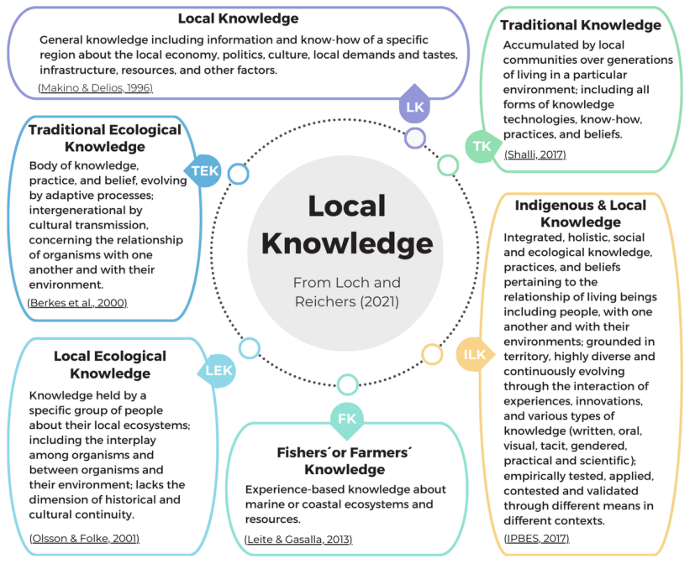
Over time, LK has been categorised in various ways to reflect differences across disciplines, countries and communities. Common terms include Indigenous and Local Knowledge (ILK), Traditional Ecological Knowledge (TEK), Local Ecological Knowledge (LEK), Fishers’ or Farmers’ Knowledge (FK) and Traditional Knowledge (TK) (see Figure 1). These share the characteristic of generational and cultural transmission of knowledge but differ in the type of knowledge transmitted. FK involves the transfer of experienced-based knowledge, while LEK and TEK focus specifically on local ecosystems and ecological knowledge. In contrast, ILK adopts a holistic approach, encompassing all practices, beliefs and knowledge. Reflecting this diversity, the UN and UNESCO recommend using “Indigenous and Local Knowledge” to acknowledge both Indigenous rights under the United Nations Declaration on the Rights of Indigenous Peoples (UNDRIP) and the contributions of other local communities. ILK is described as “holistic, territorialised, diversified and evolving knowledge (…) [that] can flourish within all kinds of long-established communities experiencing histories of interaction with their natural surroundings” (UNESCO-IOC & UNESCO-LINKS, 2024, p.11). Thus, for the purposes of this workshop and report, the term ILK is used.
While this definition highlights ILK's holistic and evolving nature, it is also important to recognise that Indigenous and local communities continuously adapt to economic, environmental and social changes, including shifts in population through in- and out-migration, evolving job opportunities and changes in transport and accessibility (Bjarnason, 2021; Heleniak & Gassen, 2020; Hovgaard et al., 2024). Climate change further drives transformations that affect livelihoods, resource use and local practices. These dynamics are evident in specific groups such as fisheries, where many coastal communities have moved from small-scale, locally embedded operations to large-scale commercial practices (Nielsen et al., 2021), reshaping both local economies and the knowledge associated with them. Such ongoing changes continually influence collective understandings of a place, emphasising that ILK is not static but evolves in response to shifting conditions. Defining and applying ILK in MSP therefore necessitates reflection on how to account for these evolving circumstances and the dynamic context in which knowledge is produced (Beaty et al., 2024; Flannery et al., 2017).
2.4 Integrating Indigenous and local knowledge into MSP
While there is growing recognition of the value of involving Indigenous and local communities in MSP processes, concerns remain about whether these processes are just and equitable in practice (Flannery et al., 2017). Planning decisions, often taken through top-down approaches, shape who benefits, who bears the costs and whose voices are given weight in decision-making. Questions therefore arise not only from the distribution of outcomes, but also from the procedures through which decisions are made and the recognition (or lack thereof) of diverse knowledge systems. To address these challenges, scholars have applied various justice-related concepts, including procedural justice (fairness in decision-making processes), distributive justice (fairness in the distribution of benefits and burdens), recognitional justice (acknowledging and respecting different worldviews and knowledge systems), community acceptance and Social Licence to Operate (SLO), among others (Beaty et al., 2024; Rot et al., 2025; Schmitt & Weck, 2024; Smith, 2018; Stronge et al., 2023).
Drawing on these justice concepts, the workshop aimed to support reflection on how ILK can be better integrated into increasingly digital MSP processes. To provide a practical framework for discussion, seven guiding principles were developed based on the justice literature outlined above. These principles translate broader justice concepts into concrete considerations for assessing ILK integration into digital MSP processes. Additionally, these principles are intended to be adaptable across contexts. Participants were encouraged to interpret and discuss justice and equity in ways that resonate with their own experiences and realities, considering how the principles might be applied or adapted in their specific settings and how they could inform the development of cases from the region.
Accordingly, each principle has been interpreted for the purposes of this workshop as a practical guide, rather than as a universal definition, acknowledging that disciplines may define them differently.
Legitimacy | Ensuring that more digital MSP processes are perceived as fair, justified and locally appropriate, thereby fostering acceptance. |
Credibility | Ensuring that digital tools and datasets used in MSP processes are accurate, reliable and transparent, fostering confidence in the information and decisions derived from them. |
Trust | Fostering conditions in which communities feel secure and confident sharing their knowledge. |
Ongoing dialogue | Avoiding one-off consultations by maintaining continuous engagement throughout processes. |
Reciprocity | Providing tangible benefits to communities in return for sharing their knowledge in MSP processes. |
Cultural integrity | Ensuring that ILK is represented in ways that preserve its meaning, context and cultural grounding, rather than reducing or decontextualising it. |
Responsiveness | Adapting tools and processes to local contexts, allowing for flexibility and responsiveness to specific community needs and environmental conditions rather than imposing a one-size-fits-all template. |