The Nordic Spatial Project
The goal of the NordicSpatial project was to design a mapping tool to facilitate collaborative efforts in basin-level planning and improve coherence of marine spatial plans across borders in the Nordic and Baltic states.
Project Activities
In order to develop a shared understanding of the competences and resources for each nation, as well as co-dependencies between nations, a project group was established. After identifying participants from relevant national agencies and establishing points of contact, the project group exchanged information on areas of responsibility, shared content, and status on marine spatial data infrastructures. This allowed for the identification of (dis)similarities between the national agencies. As a result, the project group developed a mutual understanding of the competences and resources associated with each nation, the interdependencies between them, and gained valuable insights into the different national models — knowledge that could feed back into national discussions and policy development.
Use cases were then defined through workshops with the project group, serving as planning scenarios for the prototype’s development. The main use cases explored were cooperation related to offshore wind farm planning and the designation of marine protected areas. For these use cases, relevant datasets and data owners were identified, and gaps between data maturity and user needs were analyzed. Based on findings from desktop studies, user interviews, and user testing, recommendations were made to improve data fitness for purpose and communicate these needs to data owners.
As part of the NordicSpatial project, selected datasets also underwent an assessment of their FAIR (Findable, Accessible, Interoperable, Reusable) status. The aim of this activity was to demonstrate how FAIR assessments can motivate data owners to publish data in line with international standards.
In summary, the project’s activities focused on mapping marine spatial planning processes across participating countries, identifying user stories, and compiling the data foundations necessary for marine spatial planning in each state. Based on feedback and input from national participants, BarentsWatch developed a prototype of the NordicSpatial mapping tool, which was presented to the project group in August 2023.
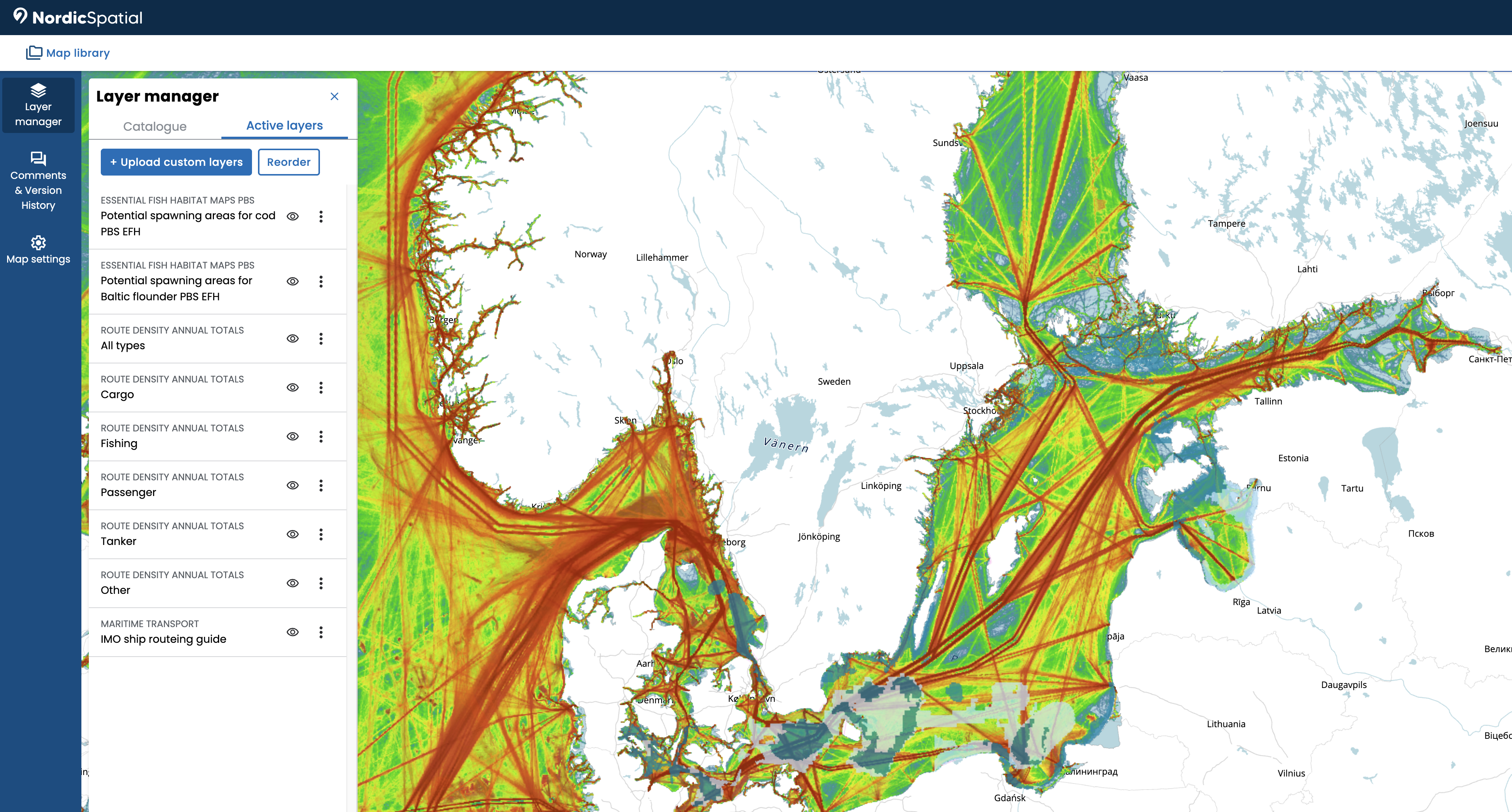
The Mapping Tool
Over the course of the project, NordicSpatial has developed a free map tool for data-sharing and cross-border collaboration for the Nordic and Baltic regions. The tool consists of a catalogue where you can stream marine geospatial data from EMODnet and HELCOM, which are the marine data portals for Europe and the Baltic Sea – where authoritative data from many sources is assembled and harmonized. The tool also allows for uploading independent WMS, GeoJSON or shapefiles, which you can control access to and combine with data from the catalogue to make and save maps. See Figure 1 for an illustration of how the map looks with added data.
The tool is free to use and requires no downloads or licenses. The need for special GIS-competences is minimal, and you can use it both in national cooperation with stakeholders or within your own agency or ministry. You can share maps and projects to provide a common understanding of each other’s spatial plans and collaborate by co-editing maps and adding comments. The tool supports version control to ensure you keep track of your work.
All maps and projects are only accessible for yourself and the users you choose to share them with. If maps or projects are not connected to an owner, they are automatically deleted when leaving the website.