
- Full page image w/ text
- Authors
- Table of contents
- Preface
- Executive Summary
- Chapter 1: Introduction
- 1.1 Aim of the report
- 1.2 The research question and its framing
- 1.3 A few general points on the historical geography of Nordic Atlantic coastal communities
- 1.4 Resilient local communities, a first theoretical framing of research
- 1.5 Global versus local value chains, a second theoretical framing of research
- 1.6 Selection of case communities
- 1.7 Wrapping up
- References
- Chapter 2: Changing value chains and contexts in Lurøy and Vega
- 2.1 Introduction
- 2.2 Historical background and resource management
- 2.2.1 Population and geography
- 2.2.2 Transport infrastructure and services
- 2.3 Population structure and change
- 2.3.1 Migration and labour markets
- 2.4 Municipal structure 2000–2020
- 2.5 Assessment of main changes in Lurøy and Vega
- 2.5.1 Inhabitants’ perceptions of their local context and expectations for the future
- 2.6 Preliminary conclusions on the resilience of coastal communities
- References
- Chapter 3: Structural changes and how they are perceived in two Icelandic towns.
- 3.1 Introduction
- 3.1.1 Earlier research on the cases
- 3.2 A socio-economic overview of the two fishing towns.
- 3.2.1 Changes in transportation
- 3.2.2 Fjallabyggð: the 2006 amalgamation and the 2010 road tunnel
- 3.2.3 Demography
- 3.2.4 Gender and age structure
- 3.3 Changes in Siglufjörður and Ólafsfjörður after the amalgamation of 2006
- 3.3.1 Fisheries
- 3.3.2 Tourism
- 3.3.3 Biotechnology
- 3.4 Changing Viewpoints in Siglufjörður and Ólafsfjörður
- 3.4.1 The regulatory impact: Inputs from the state affecting development
- 3.4.2 Changes in economic life
- 3.5 Comparing the two towns
- References
- Chapter 4: Divergent development trajectories: Tvøroyri and Vágur in the Faroes
- 4.1 Introduction
- 4.2 A socio-economic overview
- 4.3 Demographic change and settlement structure
- 4.4 Municipal structure 2000–2020
- 4.5 Changing value chains
- 4.5.1 The new local economies
- 4.6 First conclusions on the resilience of coastal communities
- Chapter 5: Value chains and social resilience in two Greenlandic towns
- 5.1 Introduction
- 5.1.1 Methods
- 5.2 Historical background
- 5.2.1 Nanortalik and Narsaq
- 5.3 Demographic changes
- 5.4 Municipal organization
- 5.5 Changing value chains
- References
- 5.6 First conclusions on the viability of Narsaq and Nanortalik
- Chapter 6: Conclusion - Comparing findings
- 6.1 Preliminary findings across cases
- 6.2 Entrepreneurs and new business developments
- 6.3 Governance and municipal structure
- 6.4 Local and global value chains
- 6.5 Resilience, resource management, and flexibility
- 6.7 Infrastructure and the difference it makes
- 6.8 Further research
- References
- About this publication
MENU
Value Chains and Resilient Coastal Communities in the Nordic Atlantic
A report from the project Sustainable Value Chains in Nordic Coastal Communities (NorValue)
Editors
Gestur Hovgaard
Jørgen Ole Bærenholdt
Authors
Gestur Hovgaard
Jørgen Ole Bærenholdt
Julien Lebel
Maiken Bjørkan
Amsale Kassahun Temesgen
Grétar Þór Eyþórsson
Sigríður K. Þorgrímsdóttir
Ragnheiður Bogadóttir
Firouz Gaini
Joan Nymand Larsen
Jón Haukur Ingimundarson
Contents
This publication is also available online in a web-accessible version at https://pub.norden.org/temanord2022-555.
Preface
In 2020 the Kingdom of Denmark took over the Chairmanship of the Nordic Council of Ministers. Its Chairmanship programme was presented as a joint programme among the three units of the Danish Kingdom: Denmark, Greenland, and the Faroes. As part of the common Chairmanship programme, Greenlandic research activity was divided into three research projects with a focus on sustainable coastal communities in the Nordic Atlantic. One project is about sustainable resource management of coastal communities fishing resources (NorSustain) and another about safety at sea with a focus on educating school children (NorSafe). The project presented in this report is developed under the title “Sustainable Value Chains in Nordic Coastal Communities” (NorValue).
Led by Ilisimatusarfik, a network involving researchers from the University of Akureyri, the Icelandic Regional Development Institute, University of the Faroe Islands, Nordland Research Institute and Roskilde University has contributed to the development of the project. This is our first report on our joint efforts to investigate sustainable value chains in Nordic coastal communities. It is expected to be followed up by another report.
Our approach is based on fieldwork in eight Nordic coastal communities in Greenland, Iceland, the Faroes, and Norway respectively. Fieldwork has been a challenging undertaking during a pandemic, and under major travel restrictions, but something that has also been instructive at the same time. Many thanks to our informants, our assistants and those who otherwise have been helpful in the process. Thanks for comments and reviews of previous drafts of the manuscript. Finally, we would like to thank the Danish Presidency of the Nordic Council of Ministers, and the Greenlandic Government in particular, for the financial support to do this project.
Ilisimatusarfik, August 2022
Gestur Hovgaard
Executive Summary
Gestur Hovgaard & Jørgen Ole Bærenholdt
As part of the Kingdom of Denmark's program for the Nordic Council of Ministers for 2020, the Greenlandic government initiated a project with the desire for updated knowledge about Nordic fishing and coastal communities, i.e., common experiences in relation to the importance of the sea's resources, new business opportunities (especially in relation to the attachment of young people) and the need for a green and sustainable transition. A Nordic interdisciplinary research group has had the task of investigating these issues, the first results of which are available with this report on "Value Chains and Resilient Coastal Communities in the Nordic Atlantic".
Products from the sea, in the form of fish and marine mammals, have historically contributed to the development of global value chains which, together with transport systems and mobile practices, have linked markets, locations and people to one other. Value chains have been central to the social interaction that has created Nordic coastal communities over time. The concept of value chain is well known in the economic and sociological literature but is applied more broadly in this project. This means that we do not merely see value chains as a vertical flow of products, technologies, and people. We also view value chains as the interaction between "vertical" structures of goods and their intersections with "horizontal" and "political" structures, i.e., both through the public sector and through civil society. Value chains can be local, regional and/or national in nature. In the interaction between the vertical and horizontal structures, both redistribution of values and social integration / disintegration occur. It is a complex interplay that is further complicated by the fact that local communities not only supply goods and services but are also places for demand and consumption. In today's local community, these local and global value chains "meet" in new ways, when, for example, local producers meet tourists. To capture this complexity, we link value chains and sustainability to the concept of resilience. Resilience has gained great importance in recent years as a concept that furthers our understanding of how local communities are able to deal with periods of local stress and crisis. In this respect, today's Nordic coastal communities are affected by two further factors that cannot be avoided. One is the global climate crisis which, in addition to new and more extreme weather conditions, also poses fundamental social questions about mobility and infrastructure. Development of infrastructure and mobile practices have been central to the development of the value chains, welfare and ways of life that have constituted the development of coastal communities. The second relationship is the COVID-19 crisis and what we can learn from a sudden collapse in value chains and mobility.
The report covers the period from the year 2000 onwards, with case studies in eight selected Nordic coastal communities, with a focus on the critical conditions and processes that have contributed to their transformation and a special look at changes in business, demography, and governance structures. We ask in more detail what specifically has changed during this period, which value chains have today become particularly important for coastal community development, as well as how this affects their sustainability and resilience.
In the report, we study coastal communities whose population has ranged between approximately 1000 and 2000 inhabitants in the past 20 years. From Greenland, we have selected the towns of Nanortalik and Narsaq in the South Greenlandic municipality of Kujalleq; from Iceland, the towns of Ólafsfjörður and Siglufjörður in the North Icelandic municipality of Fjallabyggð; from the Faroes, the municipalities of Tvøroyri and Vágur on the island of Suðuroy; and from Norway, we have chosen the municipalities of Vega and Lurøy on the Helgeland coast in the southern part of Northern Norway.
Some background characteristics, like the co-Nordic history, fishing dependency, or their status as peripheral coastal communities, are important for analysing across otherwise very different regional and national contexts. However, these are local communities with special conditions, circumstances, and development features, and in that sense each chapter in the report constitutes its own valuable description of local development over the past two decades. The chapters are descriptive in the presentation of the individual cases, to bring out local variations in the interaction between value chains and local resilience. From there, the comparative aim of the report develops an understanding of similarities and differences in processes and practices around value chains and institutional set-up across locations. It has provided the opportunity to uncover new trends and important issues in coastal community development.
The report shows that, in recent decades, Nordic coastal communities have undergone major changes in their industrial structures. The cornerstone of many local communities' development – locally based fishing and fish factories – has lost the importance it once had; indeed, in several places these activities have more or less disappeared. Although there are still what can be termed one-industry locations, there is a clear trend towards the coastal community's production life becoming increasingly diversified. In the current industrial transition, it is still predominantly value chains rooted in natural resources that dominate the local economies, particularly towards aquaculture. Tourism represents a further diversification in all our cases, and we see examples of development towards advanced production within the biotechnology field. In addition, there is a continued anchoring and development in household-based activities (local value chains), both as a continuation of traditional flexible households and as an element in tourism and small-scale production. Across the cases, place- and person-specific factors, and their links to locally oriented institutions are of great importance for the development of business life and resilience. If there is weak infrastructure and weak institutional arrangements, values - economic and social capital - are drained away from the local community.
In the conventional sense, most of our cases can be considered economic successes, with a high degree of resilience, but also cases with challenges. One challenge lies in the fact that when business ownership is located outside the local community, local dependence on global value chains increases, and the ability to absorb periods of crisis lessens. There is a complementary need for increased understanding of interactions among different industries, and how these relations might contribute to local resilience. Here are also challenges in finding solutions involving climate and sustainability, e.g., the fact that many coastal industries depend heavily on the consumption of fossil energy.
Our results may also call into question some of the conventional truths about coastal community development. The coastal community populations are clearly declining, with increased ageing and a skewed gender balance. Our cases show that these declines occur even where there is economic success. You might say that the social structure of the coastal community itself is to some extent 'de-localized'. The mobility practices of the younger generation to move away for education, and then possibly not return, is well known. Many coastal communities are instead attracting people who have not been brought up locally. There are indications, however, that younger as well as older generations prefer to maintain ties with a coastal community and become a kind of non-permanent local, where it can be combined with work, leisure, entrepreneurship, or other vital interests. When houses are empty locally, it can of course be an expression of a problem, but it can also be an expression of the existence of economic and social resources that can contribute to new forms of local resilience. The question is whether the decline in population numbers and the trend to a non-permanent local settlement pattern can contribute to local resilience and sustainability.
Chapter 1: Introduction
Jørgen Ole Bærenholdt & Gestur Hovgaard
1.1 Aim of the report
This report aims to establish a comparative understanding of trends in Nordic Atlantic coastal communities. With contributions from researchers with different academic backgrounds, we develop a common interdisciplinary understanding based on findings from eight Nordic Atlantic coastal communities in Greenland, Iceland, the Faroes, and Norway. We focus on: a) what are the critical dimensions of contemporary transformations; and b) what are the similarities and differences among the cases? The transformations studied include ongoing socio-economic restructuring of the value chains that the local communities depend upon. We find that a main common trend is diversification of the local economy, where fisheries and the traditional fish factory no longer have the same dominant position. We also find that the economic sectors evolving are increasingly globalised salmon farming, as well as tourism, biotechnology, mining and more localised cultural production and development in food production. At the same time, more traditional forms of subsistence or household economy still play a role in local life and wellbeing. Importantly, transformations may follow some generalizable patterns, but are far from universal. Thus, the central aim of this report is to examine how our eight different coastal communities have developed since 2000. The report is based on case studies, each of which unveil their specific situations and trajectories. We are combining these insights with previous research and theoretical insights.
The selected local communities are not meant to represent their region or country, but communities which are undergoing transformative changes within or beyond traditionally dominant fisheries activities. They may inform future possibilities.
We investigate the transformation of local communities researched by responding to these questions:
- How has the population changed in the period since 2000 with respect to gender, age and employment? We link these data to the specific economic sectors in which people in the local communities are employed. Is there diversification in the local economy, and how are changes in the local economy linked to the livelihoods of young people?
- How are local communities governed? In particular, have there been changes in local/municipal governance structures, and what are their implications? In addition, we are interested in whether municipal or other governance structures are capable of regulating access to different natural resources relevant to the economic sectors. Have local communities managed to redefine their role at a time in which municipal amalgamations took place?
- How did local economic structures change? What are the value chains most important for the local community? How did value chains change, and new businesses, products and functions emerge? These changes include e.g. developments in knowledge-based activities, a reorientation towards local food production, as well as changes in how tourism develops in conjunction with natural and cultural heritage.
These three topic areas overlap, and we will explain how, with examples from the eight coastal communities we investigate. Furthermore, our research reflects on the importance of two major trends, which became ever more central during 2020 and 2021:
- The global climate crisis, leading not only to the need to adapt to new and more extreme weather situations, but also to the immense challenges to transform the infrastructures and mobility practices which have been so central in the modernization of coastal communities and their value chains.
- The COVID-19 health crisis, which heavily affected how people adjust their mobility practices, jobs, educational possibilities, as well as value chains. We do not yet know where the pandemic fits on the continuum between a ‘new normal’ and a return to ‘business-as-usual’.
1.2 The research question and its framing
The NorValue project investigates how people in Nordic Atlantic local communities are involved in connections and linkages crucial to their survival and livelihoods, as a part of the Nordic Atlantic societies of Greenland, Iceland, the Faroes and Northern Norway. This first report provides descriptive accounts of our approach, and developments in the coastal communities studied. We will focus on one main research question: Based on a local and historical perspectives, as well as insight into changes in demography and political regulation from 2000, how have the value chains most important for local communities, changed?
For centuries, settlements, villages and towns have developed through their integration in value chains connecting communities and their natural resources to businesses and customers in other parts of the world. Through these value chains and the associated forms of transport, people in the Nordic Atlantic are suppliers to increasingly globalised markets for raw materials, products from marine mammals, fisheries, aquaculture, tourist experiences and services. These value chains are key to producing the wealth of Nordic Atlantic coastal communities. The concept of value chains also implies the redistribution of value and societal integration. Here we focus on the public sector and other local, regional, and national associations, and how intersection with value chains redistributes wealth among citizens, where people share their wealth to survive and to prosper. In this way, value chains are not only ‘vertical’ in the form of products and services delivered to produce value, but also ‘horizontal’ and political when value/wealth produced is shared and redistributed. Finally, we understand Nordic Atlantic local communities as not only places of production and supply, but also places of consumption and demand, where people have become part of far-reaching consumer cultures. Thus, when it comes to the economy of shops and restaurants in Nordic Atlantic local communities, value chains are complex, since customers are both locals and tourists.
Inspired by the UNESCO MOST Circumpolar Coping Processes Project, which studied local community development to the beginning of the 2000s (Aarsæther & Bærenholdt, 1998), we investigate the capacity of communities to absorb and adjust to the transformation of value chains. Here we use the term community without presupposing that people living in the specific geographical place or location are part of a working social or cultural community. ‘Community’, as also in ‘coastal community’ or ‘local community’ is only used as a descriptive term for ‘a geographical entity and synonymous to “village”’ (Kokorsch & Benediktsson, 2018, p. 99). We could have used the terms village (bygd) or town (by), but since the meaning of bygd and by differs among the Nordic countries, we use ‘local community’ in this descriptive way corresponding to the Norwegian or Danish word lokalsamfund. We do not assume that people living in the local community constitute a real cultural community of people sharing values and identities. On the other hand, as we will explain below (in discussing ‘geo-social position’), we do assume that people living in the same places also share some common interests and concerns, since living conditions are also tied to how local communities develop. We will also explain, in each case study, how local communities are connected to the organisation of local and national authorities (municipalities, counties/regions [in Norway] and states). Furthermore, some local communities are more stretched out in space, with scattered smaller units (small villages, farms, or other settlements) attached. In this way, local communities are in fact combined geo-social units.
We suggest that the processes in these local communities can be compared, and that more insight about the specific characteristics of processes in each of the local communities is gained from our comparative analysis of eight local communities. It is thus our aim to use the multi-case and multi-site comparative analysis to gain deeper insight into the different ways coastal communities may develop in the Nordic Atlantic, while they also share some general conditions as part of Nordic societies and peripheral communities. This said, focusing on global value chains also implies that processes of interest are not only within local communities. It is exactly a common general characteristic of these coastal communities that they have all been tied into value chains connecting them to distant markets for fish, and increasingly for tourism, blue economy, and culture economy activities.
1.3 A few general points on the historical geography of Nordic Atlantic coastal communities
The development of Northern Norway, the Faroes, Iceland, and Greenland share several common patterns (see Bærenholdt, 2007, p. 3–7; p. 65–94). As part of a more or less common Danish colonial heritage, societies and local communities evolved over centuries through dependence on marine resources, which became the material foundations of a system of trade monopolies, and later formed the basis for industrialisation and modernisation in the nineteenth and twentieth centuries. This implies that there is a long history of what we today call global value chains, where fish and other marine resources from the area studied provided important resources for other countries, especially European ones. Even before Danish trade monopolies were introduced, the area saw Hanseatic trade, like Dutch whale hunting, where blubber from Greenlandic whales were a source of lighting in European cities. Further, Christianity, and later the Reformation, were also central parts of the social organisation of communities along the coasts, where missionaries were also sent out to ‘socialise’ the indigenous Sami and Inuit people.
However, there are also major differences among the lands and coasts of Greenland, Iceland, the Faroes, and Northern Norway, especially in terms of distance and possibilities for transport and infrastructure. Moreover, the timing of historical developments makes a difference. All these regions have had trade monopolies, where only subjects of the King of Denmark were allowed to trade. In Northern Norway the monopolies were abolished in 1789, and they were also formally abolished in Iceland in 1787. In the Faroes, the trade monopoly, in different forms, remained until 1856 and ‘trade monopolies’ persisted in Greenland until 1953, although their influence continued beyond the abolition of formal colonial rule (Bærenholdt, 2007, p. 65–94). While trade and shipment of marine resources, along with religion, played a central role in the Nordic Atlantic, there are also important historical differences which need consideration when comparing local communities today.
Many Nordic Atlantic communities still depend on being suppliers of marine resources from fisheries and aquaculture. However, in some Nordic Atlantic coastal communities more than others, people have managed to diversify their economy. Many different economic sectors are relevant, including machine manufacturing and repair, construction, handicrafts, and business services, but there are substantial variations among local communities. Different infrastructural configurations add to and are tied into this complexity. The Faroes, Northern Norway and Iceland have succeeded in connecting many of their local communities through roads and tunnels, but Greenlandic communities still are only connected by sea and air transport. The biggest overall differences, both in terms of history and infrastructure/geography, are between Greenland and the three other countries. As we will see in the following chapters, there are also similarities in how local communities develop. To mention a few general examples:
- Local economic development and innovation often occur through the involvement of entrepreneurs, who are individuals with bridging connections who have decided to get involved in developing local business through fisheries, biotechnology, or tourism. In the small local communities, we are investigating, local entrepreneurship is sometimes missing. In these cases, the involvement of just a few entrepreneurs can be decisive, especially if they have committed themselves to local community development. Further, development of new businesses, as in aquaculture, attracting capital beyond the ability of single entrepreneurs, has been crucial for some of our communities.
- Public investment and decisions on infrastructure, like the location of schools or other public institutions, can become important drivers for development. While young people generally tend to leave rural areas, the opportunity for upper secondary school (high school) in an area can make a crucial difference, not only for young people, but also for those employed in schools and the community at large.
- Additionally, municipal structures matter. On this point, our case material contain interesting differences in how small or large municipalities are organized in terms of the number of inhabitants and territorial area. We will see how different processes of municipal amalgamation turn out.
- Finally, flexible household economies are decisive for sustaining livelihoods for many people in the rather peripheral location of the communities studied. Households which are dependent on the value chains of one economic sector alone are vulnerable, and therefore many households try to continue a centuries-long tradition of combining different sorts of income. Some of these activities are more global and some more local, a kind of ‘diversification from below’.
Local community development is not only about business, nor only about public governance, nor only a matter of local engagement among people, but a complicated mix of many factors. We will investigate how such factors are interconnected, and under what conditions there are synergies among the dimensions of business, government, and civil society. Attending to these interconnections and synergies is something supported by the theoretical approach discussed in the next section.
1.4 Resilient local communities, a first theoretical framing of research[1]Parts of the text in this and the next theoretical section was developed as part of the paper ’Local versus global value chains in Nordic Atlantic local communities’ (Bærenholdt & Hovgaard, 2021) in preparation for publication.
With the 2020 outbreak of the COVID-19 virus, even in places as far away as our south Greenlandic case communities, consequences were immediately noticeable. The number of cruise ships and regular flights sharply decreased, so local livelihoods and economies had to adapt quickly to a new situation. In many ways it is not new for Greenlandic – or Nordic Atlantic coastal societies – to face fundamental questions about how to reorient to survive and secure livelihoods. In their long history, they have been produced and reproduced through numerous forms of mobility, building societies through connections, internally and externally (Bærenholdt, 2007). But when a small event in a marketplace in China can quickly escalate into a major local crisis, there is something fundamentally new happening. Both the global climate crisis and the COVID-19 pandemic are undeniable cases of societal dynamics that are unpredictable yet irreversible, as explained in complexity theory (Urry, 2003). Following Lovelock’s Gaia thesis, both developments systematically raise questions about how human life can continue on Earth. First and foremost, they are examples that we need to learn to adjust for, but also to reorient societies in more resilient ways. Not only do communities need to cope with the threats of these crisis, but they also require major innovations that go beyond economic change to be environmentally and socially sustainable. This – in our view - implies a reorientation of politics and governance towards an ‘earthly’ commitment to the concrete contexts in nature, where people live Down to Earth (Latour, 2018; and see Bærenholdt et al., 2021). Taking the concrete ‘geo-social’ positions in which people engage with such a reorientation seriously is central to the kind of research we are undertaking.
To deal with the climate crisis, Latour (2018) suggests that the global-local tension is no longer dominant; the tension is now between the earthly who address climate and environmental questions and the non-earthly, who ignore these issues. This orientation leads Latour’s approach into a focus on people’s very concrete ‘geo-social position’. This implies an orientation to localised communities (people-locality assemblies) acting collectively in accordance with, and in relation to, their concrete material surroundings. This is not about approaching Planet Earth from any distant location in space, but it is about how people in their places cope with problems, which are local and global at the same time.
We suggest approaching this complex situation in local communities with a combination of resilience thinking and the value-chain approach. Let us begin with resilience. The strength of resilience thinking is its attention to how societal units are able to cope with stress and crisis. “’Resilience’ is described as an ability which enables societies to maintain their social and ecological balance in times of crisis and failure” (Fontanari & Kredinger, 2018, p. 14). Resilience thus highlights the capacity of societies or of communities to recover from stress (Zacher, 2018, p. 53). It involves a “…focus on internal strengths, existing resources and authentic potentials…” (Fontanari & Kredringer, 2018, p. 15), implying that there is an assumption of strength in being disconnected. This leads to studies of degrees of dependence on outside resources if a crisis emerges, and much research on resilience is focusing on to what extent societal units depend on provisions from outside. The specific contribution from the resilience idea is to focus on systems’ or communities’ capacity to absorb disturbance through reorganization (Saarinen & Gill, 2019, p. 5), with a focus on “…decoding the sustainability challenge through smaller adaptive actions that allow socio-ecological systems to rebalance and cope with change” (Dredge, 2019, p. 53).[2]An earlier version of this paragraph was first developed as part of the paper ‘Citizen-driven mobilization for “small tourism” in a marginal place: a case of resilience practices’ (Bærenholdt, Fuglsang and Sundbo, first presented by Bærenholdt at the Nordic Geographers Meeting, Trondheim, June 2019), and later published in Bærenholdt et al. 2021. In conclusion, resilience thinking clearly is based on some of the same ideas as coping and geo-social positions.
Kokorsch & Benediktsson (2018) have applied resilience thinking in a case study of two coastal communities in Iceland, smaller than the ones we study in this report. They see resilience thinking as a way to facilitate bottom-up and empowerment strategies in situations of vulnerability and suggest relating these perspectives more to crucial policy changes, such as the ITQ (Individual Transferable Quotas) regime shift in Icelandic fisheries management from 1990 onwards. Kokorsch and Benediktsson investigate how the two small peripheral North Icelandic communities of Skagaströnd and Raufarhöfn both expanded with herring and other fisheries in the 1960s and the 1970s, but in both cases the introduction of the ITQ regime led to loss of quotas in fisheries and a collapse of the fishing industry. But while Skagaströnd managed to attract new initiatives in research, education and art, diversification was not possible in Raufarhöfn, leading to a much steeper decline in population than in Skagaströnd. Part of the background to this difference is the fact that Raufarhöfn is located much further away from urban centres, not only with higher transport times and costs, but also with slow internet connections. Municipal amalgamation enforced by a long period of economic stress and outmigration also made people in Raufarhöfn aware of the problems linked to how their businesses were dealt with at a distance by people who may not even come to an isolated place like Raufarhöfn. Still, in both communities, tourism and cultural attractions are on the agenda for future development. The Kokorsch and Benediktsson study is instructive in explaining the different processes leading to resilience (Skagaströnd) or non-resilience (Raufarhöfn), where the limits to resilience in a coastal community relate to changes in fisheries regimes, and the remoteness of Raufarhöfn.
Dependence on natural resources and the challenge of remoteness is also investigated in several Arctic cases by Larsen and Lee (2020, p. 28), where “resilience of specific places amid change” is understood as a temporary state between long-term sustainability on one side and unsustainable economies on the other side. Resilience is clearly a concept to understand how to manage the demanding task of securing the survival of general human and social organisation in situations of stress and crisis. The concept also hints at how people can cope with the uncertainties of everyday life in peripheral locations, where one may not feel certain about the robustness of crucial things in life, such as a ferry connection, a school or a kindergarten.
A more regional level approach to resilience is found in Giacometti and Teräs (2019). They see trust and cohesion as drivers of the capacity to adapt and stay flexible. Here, globalization is seen as a source of vulnerability and shocks, challenging the sustainability of Nordic regions. But there is also an awareness that regional and local resilience is not the same. Strong public-sector institutions are seen as an important element in resilience at both local and regional levels. The approach to resilience in Giacometti and Teräs (2019) is more about system thinking than the present report, and it also includes studies of ‘regions’ with very different scales. It is, however, interesting that many of the types of shocks or stresses that resilience has to react to in regions studied by Giacometti and Teräs are about value chains, in the form of ‘markets’, that were disrupted. As in our approach, Giacometti and Teräs (2019, p. 78) also suggest diversification as a central element of resilience.
As suggested above, we combine the resilience approach with value chains, since it seems that these two approaches contribute to complementary insights. The key contribution from resilience thinking – that diversification helps robustness – also points to the importance of value chains for local communities, if they are to diversify.
Footnotes
- ^ Parts of the text in this and the next theoretical section was developed as part of the paper ’Local versus global value chains in Nordic Atlantic local communities’ (Bærenholdt & Hovgaard, 2021) in preparation for publication.
- ^ An earlier version of this paragraph was first developed as part of the paper ‘Citizen-driven mobilization for “small tourism” in a marginal place: a case of resilience practices’ (Bærenholdt, Fuglsang and Sundbo, first presented by Bærenholdt at the Nordic Geographers Meeting, Trondheim, June 2019), and later published in Bærenholdt et al. 2021.
1.5 Global versus local value chains, a second theoretical framing of research
The concept of global value chains emerged around 2010 out of previous investigations of global commodity chains in economic geography and international development studies. These studies especially address issues in the Global South (Ponte, Gereffi & Raj-Reichert, 2019). Looking back at the research tradition he led, Gereffi explains that the Global Value Chains (GVC) approach was an attempt to establish an “integrated research framework that could link the macro (global), meso (industry and country) and micro (firm and community)” (Gereffi 2018, p. 16). Many of the GVC studies focus on the connections and links across locations and scales, as in trade with agricultural products around the globe. However, the local, or community, aspect is less central for most of these studies.
However, it is obvious that some value chains are more vulnerable than others. For example, long-distance tourism increasingly appears to be risky business. More generally, value chains need to be changed in order to meet the goals of “responsible consumption and production” as set out in Objective 12 of the United Nations Sustainable Development Goals (United Nations, n.d.). We can also discuss and investigate measures to decouple distant, unsustainable connections, and investigate small-scale production (Carr & Gibson, 2016).
We also suggest rethinking the ‘local community’ (as discussed in sections above) by investigating local value chains, and analysing the ties and relations among local people. This implies firstly, that people can have very different kinds of attachments to the actual place; they can be inhabitants, second-homers, regular visitors, someone who grew up in the community, immigrants, and the like. Second, focusing on value chains implies an acknowledgement of people as various kinds of economic agents taking part in a game with various kinds of benefits (Rosales et al., 2017, p. 12). But third, the value chain approach also means approaching the governance of value chains, thus mapping the relations and institutions involved in the coordination and distribution of benefits.
An interesting paper by Bolwig et al. (2010) hints at a similar route to improve value chain analysis. One of the central critical points has been the need to examine how local agents can upgrade their position in a value chain, and avoid the risks and vulnerabilities involved in being tied up in interventions and systems downstream. Bolwig et al. (2010, p. 175) explain how this problem arises with the focus on the vertical elements in value-chain analysis. In search of horizontal elements in value-chain analysis, it is therefore interesting to observe that “exclusion or marginality is not necessarily disadvantageous“ (Bolwig et al., 2010, p. 178). Similarly, Neilson (2019) found that often upgrading in global value chains is only an advantage to local elites in sustaining their own benefits. Neilson suggests an alternative approach to ‘sustainable livelihood’ which addresses how people are engaged in small-scale household production, where each household depends on several economic activities. Diversification through subsistence economies like hunting seals or growing root crops – both at household and local community levels – can therefore be a source of resilience, at both levels. Analysing local value chains should build on this insight. Local value chains may include both formal and informal relations, where economies may be dispersed beyond the purely local through kin networks and geographic mobility. The decisive point in relation to global value chain analysis is therefore not only the orientation towards people’s ‘geo-social’ positions, but also to acknowledge that value chains go beyond the scope of firms.
However, studying livelihoods in contemporary modern Nordic Atlantic coastal communities still needs to consider the central economic role of global value chains, which can be decisive in communities depending on fisheries, aquaculture, or tourism, or where a small number of companies dominate the economy. It is still important to examine how value chains, both local and global, are managed and governed. Value chain governance should be studied by investigating the “…concrete practices and organizational forms through which a specific division of labour between lead firms and other actors arise and is managed…” (Ponte et al., 2019, p. 1). Investigating this is not an abstract and general process, but a very concrete task.
The main point is to map the most significant value chains, selected because of their importance for many people in a particular local community. Further, we need to outline how particular local activities are part of a global value chain. For example, how is local salmon farming via multinational companies positioned within that global value chain? And how are these activities related to other local economic practices, and which are the local value chains involved? These activities may involve technical, financial, transport or cleaning services, or they may be about the supply of materials needed. In addition, land ownership and access to natural resources are always central issues. This approach to local value chains is much broader than the one seen in development research and business studies (Lee, Szapiro & Mao, 2017; Rocha & Abreu 2018), where the focus is only on value chains within a particular industry.
There is an unresolved tension in research between business oriented and broader approaches to local and regional development. Parrilli et al. (2013) provide an interesting discussion of the possible contributions, not only from a Global Value Chains (GVC) perspective, but also from Global Production Networks (GPN) and Global Innovation Networks (GIN) on local and regional development. This comparative review, among others, finds that the GVC literature is particularly strong on governance issues and on value distribution. However, it is striking to what degree these different approaches concentrate on firms and industries, without any deeper discussion of how the dynamics of industrial development and innovation affect local and regional development for people. In this report, we aim to focus on local development, and will return to further discussing the value chain approach in the concluding chapter.
1.6 Selection of case communities
To investigate the complex situations affecting the resilience of local communities, and how they are tied into changes, we have chosen to do case studies of the processes taking place in and around eight different local communities, two in each of the countries involved. With an interest in processes of change, we also suggest that insight into the specific processes in and around each local community can be gained by comparing the cases. To do this, it is an advantage if local communities are comparable on a few essential background parameters. First, we study local communities in four Nordic Atlantic countries, and their overall similarities and differences are discussed above. The Nordic character of these societies, together with their coastal location, define the first overall common background context. Second, the more precise location or place of local communities’ matter, since there are huge regional differences within each of the four countries. Since we do not intend to study these differences in detail, but rather want to get deeper insight into particular processes, we have chosen to select two local communities in each country which are located relatively near to each other and share some intraregional features. Third, and perhaps most important, we chose local communities which in some of the years between 2000 and 2021 had between 1,000 and 2,000 inhabitants (see the localities listed in table 1.1).
It should be noted that there are many local communities in the 1,000–2,000-size range in these areas, where most of them have rather concentrated settlements. This is a common characteristic of coastal villages, historically developed around a port, and some industries related to that location, primarily through the processing and use of marine resources. Most of these coastal communities have, or used to have, one or more fish processing plants which are, or were, central to the local labour markets. The central role of plants for frozen fillets peaked in the 1970s, which was also the decade in which welfare state developments, including many public-sector jobs, were prominent. Some of these developments were dismantled in the 1980s and 1990s, with rural depopulation again becoming a fairly common feature. Still, villages (bygd in the Faroes) and towns (in Iceland, or historical ‘colonies’ in Greenland) with 1,000 to 2,000 inhabitants are large enough to have the shops, kindergartens, and elementary schools crucial for local communities. These arrangements imply institutional stability in the community, making family life possible. These local communities are also more than seasonal tourist sites. However, some of these local communities are also sites for non-permanent residents, regularly visiting their cottages or second homes. The non-permanent residents contribute – sometimes significantly – to local shops, services, and construction. Non-permanent residents (Bærenholdt et al., 2021) are not included in the demographic data in table 1.1. Thus, some of the decline we see in table 1.1 probably means that people have given up living permanently in a local community (while they may have kept their houses as family resources, and perhaps a reunion location).
| Population 1 January* | |||
| Local community | 2000 | 2021 | Change |
| Narsaq # | 1.714 | 1.392 | -18,80% |
| Nanortalik # | 1.538 | 1.169 | -24,00% |
| Siglufjörður | 1.559 | 1.165 | -25,30% |
| Ólafsfjörður | 1.036 | 770 | -25,70% |
| Tvøroyri | 1.783 | 1.744 | -2,20% |
| Vágur | 1.403 | 1.392 | -0,80% |
| Vega | 1.414 | 1.182 | -16,40% |
| Lurøy | 2.107 | 1.876 | -11,00% |
| * 2000 numbers for Siglufjörður and Ólafsfjörður are 1 December. # dispersed small villages and farms in Narsaq and Nanortalik districts not included. | |||
Table 1.1: Population in the case communities, 2000 & 2021.
Source: Statistics Greenland, Statistics Iceland, Statistics Faroe Islands & Statistics Norway.
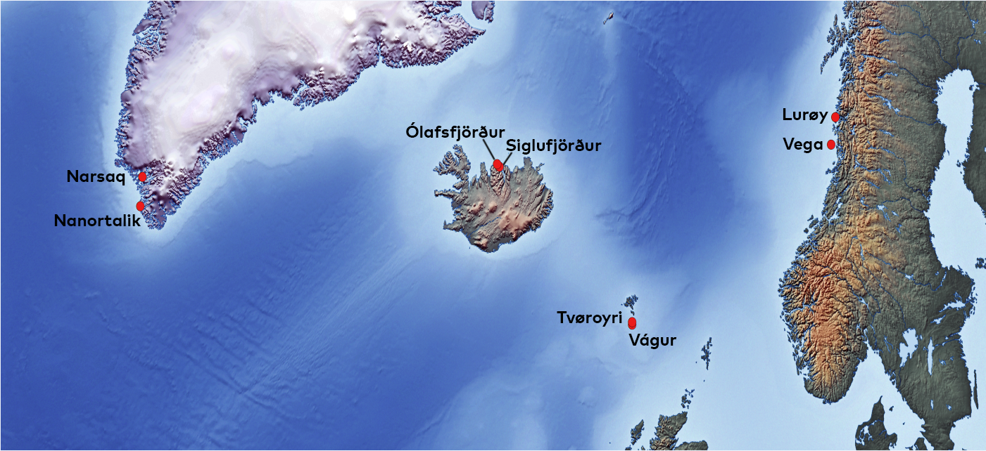
Map 1.1: Map of the location of the eight cases of local communities in the NorValue project
Source: map produced by Ragnheiður Bogadóttir.
As we will see in the following chapters, considerable change has happened in industrial structures, some ‘cornerstone’ companies have left, others stayed, and new businesses, such as in tourism or technology-intensive industries, have developed in the first two decades of the twenty-first century. We also need to add that the settlement structure is generally more complex than described so far. The coastal communities in the Nordland region of Norway generally have more dispersed settlements near a few larger towns/cities, like Bodø and Mo i Rana. Furthermore, there are some scattered farms in each of the Norwegian communities, something which also is true for the particular villages chosen in South Greenland, as opposed to the rest of Greenland.
There are also complex relations among municipal governments and local communities in each country/region. All eight local communities, at some point, were also separate municipalities, but amalgamations have taken place in Iceland and Greenland. Narsaq and Nanortalik are two of three ‘towns’ in South Greenland. Until the comprehensive Greenlandic municipal reform in 2009, each of the towns were centres in their own municipalities. But the reform dramatically reduced the number of municipalities to only four – later revised to five – municipalities. Since 2009 Narsaq and Nanortalik became part of the new Kujalleq municipality. As we will see, this process is one of the major changes in the period studied. Narsaq and Nanortalik are interesting because of this process, but also because South Greenland has a peripheral status in Greenland’s socio-economic development. There are no roads between local communities in Greenland; all transport takes place via sea or air. Because of long distances, numbers in table 1.1 are only for the towns of Narsaq and Nanortalik, although both include several smaller villages and farms, which also have experienced declining population.
Siglufjörður and Ólafsfjörður in northern Iceland were separate municipalities until amalgamated into the common municipality of Fjallabyggð in 2006. This was a turning point in the decades studied, although this amalgamation took place in a different context than in Greenland. Like the Greenlandic cases, infrastructural issues are central here, since the amalgamation was followed by the construction of a tunnel between the two communities in 2010. This tunnel not only reduced the distance between the two places, but also supported a further integration of the overall region. This was especially true for the new connection between Siglufjörður and Akureyri, ‘the capital’ of northern Iceland, and Iceland’s second largest city.
Vágur and Tvøroyri are located on Suðuroy, which is the most populated of the inhabited islands of the Faroes that do not have road connections to the otherwise well-connected regional labour markets in the Faroes. They are both separate municipalities, among numerous smaller municipalities on Suðuroy. Tvøroyri, in fact, comprises several villages, near to each other. Distances on Suðuroy are short, and the ferry to Tórshavn on ‘the mainland’ takes a bit more than two hours. Vágur and Tvøroyri are interesting because of Suðuroy’s specific infrastructural situation, which is comparable to South Greenland and the ‘insular’ location of the Norwegian cases.
Lurøy and Vega are island municipalities on the Helgeland coast of Nordland, the most southern of Northern Norway’s two regions. Both municipalities include numerous islands, connected by ferry links. Although Lurøy has its town hall on Onøya, and the population is distributed across several islands, the socio-economic centre is Lovund, an aquaculture centre. Vega has almost all its population on the island of Vega, including its town hall. Vega is famous for being on the UNESCO World Heritage list, which adds to tourism development. Both Norwegian municipalities are interesting because of their insular infrastructural situation, which makes the routing of ferry connections an ever-present issue.
1.7 Wrapping up
We find the eight local communities in this study interesting, since they, as argued above, represent contrasting conditions, making comparative analysis particularly interesting. Furthermore, we argued that it contributes to the solidity of the analysis to focus on two local communities within each country/region, which share some common features, like belonging to the same municipality, or being located on the same island, or in a similar insular location. The solidity of studying local communities in pairs comes from the extra evidence we get from having two different communities sharing a historical, geographical, and societal context, which we thereby get to know better. Comparing across countries then adds to understanding the specific institutional set-ups in each of the countries. This is important, because local communities are in no way isolated social units but integrated into global value chains. As we will see, the specific mode of governing and doing business in each country means a lot.
In practice, our work has been carried out in such a way that the national universities have been responsible for the studies in their respective countries. In addition, each individual group has had the freedom to arrange their research according to the local circumstances, in relation to prior research and the difficulties created by the COVID-19 situation. The Icelandic and Norwegian case studies are thus based on surveys in the individual local communities, while the Greenlandic and Faroese case studies are based on observations and interviews in the field. However, these differences in methods are still part of a common study design and a theoretical structure.
References
Aarsæther, N. & Bærenholdt, J.O. (1998). Fieldwork Manual – Circumpolar Coping Processes Project. In N. Aarsæther & J.O. Bærenholdt (Eds.), Coping Strategies in the North: Local practices in the context of global restructuring (pp. 223–226). MOST and Nordic Council of Ministers.
Bærenholdt, J.O. (2007). Coping with Distances: Producing Nordic Atlantic Societies. Berghahn.
Bærenholdt, J.O., Fuglsang, L. & Sundbo, J. (2021). A coalition for ’small tourism’ in a marginal place: Configuring a geo-social position. Journal of Rural Studies, 87, 169–180.
Bolwig, S., Ponte, S., du Toit, A. & Halberg, N. (2010). Integrating Poverty and Environmental Concerns into Value-Chain Analysis: A Conceptual Framework. Development Policy Review, 28(2), 173–194.
Carr, C. & Gibson, C. (2016). Geographies of making: Rethinking materials and skills for volatile futures. Progress in Human Geography, 40(3), 297–315.
Dredge, D. (2019). Governance, tourism and resilience: A long way to go? In J. Saarinen & M. A. Gill (Eds), Resilient Destinations and Tourism: Governance Strategies in the Transition towards Sustainability in Tourism, (p. 48–66). Routledge.
Fontanari, M. & Kredringer, D. (2018). Risk- and resilience-awareness: An empirical analysis of the basic supply in regions and on the demand side. In E. Innerhofer, M. Fontamari, & H. Pechlaner (Eds.), Destination Resilience: Challenges and Opportunities for Destination Management and Governance (p. 14–32). Routledge.
Gereffi, G. (2018). The emergence of Global Value Chains: Ideas, institutions, and research communities. In G. Gereffi, Global Value Chains and Development (p. 1–39). Cambridge University Press.
Giacometti, A. & Teräs, J. (2019). Regional Economic and Social Resilience, Nordregio report 2019:2. Nordregio.
Kokorsch, M. & Benediktsson, K. (2018). Where have all the people gone? The limits of resilience in coastal communities. Norsk Geografisk Tidsskrift, 72(2), 97–114.
Larsen, J.N. & Huskey, L. (2020). Sustainable economies in the Arctic. In J. K. Graybil & N. Petrov (Eds.), Arctic Sustainability, Key Methodologies and Knowledge Domains: A synthesis of knowledge (p. 23–42). Routledge.
Latour, B. (2018). Ned på Jorden: Hvordan orienterer vi os politisk? (From the French: Où atterir? Comment s’orienter en politique, 2017). Informations Forlag.
Lee, K., Shapiro, M., & Mao, Z. (2018). From Global Value Chains (GVC) to innovation systems for local value chains and knowledge creation. European Journal of Development Research, 30(3), 424–441.
Neilson, J. (2019). Livelihood upgrading. In S. Ponte, G. Gereffi & G. Raj-Reichert (Eds.), Handbook on Global Value Chains (pp. 290–309). Edward Elgar.
Nordic Council of Ministers. (2019). Working Together on Solutions for the Future. Danish Presidency 2020. Appendix. PolitikNord 2019:752. https://norden.diva-portal.org/smash/get/diva2:1362970/FULLTEXT01.pdf. DOI: http://dx.doi.org/10.6027/PN2019-752
Parrilli, M.D., Nadvi, K. & Yeung, H. W.-C. (2013). Local and regional development in global value chains, production networks and innovation networks: A comparative review and the challenges for future research. European Planning Studies, 21(7), 967–988.
Ponte, S., Gereffi, G. & Raj-Reichert, G. (2019). Introduction. In S. Ponte, G. Gereffi & G. Raj-Reichert (Eds.), Handbook on Global Value Chains (pp. 1–27). Cheltenham: Edward Elgar.
Rocha, R. & Abreu, M. (2018). Emerging strategies and flexible forms of governance: The dynamics of role exchange in local value chains. Competition & Change, 22(4), 363–382.
Rosales, R.M., Pomeroy, R., Calabio, I. J., Batong, M., Cedo, K., Escara, N., Facunla, V., Gulayan, A., Narvadez, M., Sarahadil, M. & Sobrevega, M. A. (2017). Value chain analysis in small-scale fisheries management. Marine Policy, 83, 11–21.
Saarinen, J. & Gill, M.A. (2019). Introduction: Placing resilience in the sustainability frame. In J. Saarinen & M. A. Gill (Eds.), Resilient Destinations and Tourism: Governance Strategies in the Transition towards Sustainability in Tourism (p. 3–12). Routledge.
United Nations (n.d.). Goal 12: Ensure sustainable consumption and production patterns. https://www.un.org/sustainabledevelopment/sustainable-consumption-production/
Urry, J. (2003). Global Complexity. Polity.
Zacher, D. (2018). From resilience thinking to resilience practice: Perspectives on destination development. In E. Innerhofer, M. Fontamari & H. Pechlaner (Eds.), Destination Resilience: Challenges and Opportunities for Destination Management and Governance (p. 14–32). Routledge.
Chapter 2: Changing value chains and contexts in Lurøy and Vega
Julien Lebel, Maiken Bjørkan & Amsale Kassahun Temesgen
2.1 Introduction
Local communities in Northern Norway have experienced major transformations in the past few decades. While the effects of climate changes and population decline are leading to significant challenges for their future, growing tourism and aquaculture activities brought development opportunities, but also some controversies. In this chapter, we focus on the municipalities of Lurøy and Vega, both located on the Helgeland coast, in the southern part of Nordland County. Local communities in these municipalities are coping with common challenges due to their coastal position and their negative demographic trends since the 1960s.
Lurøy and Vega have specificities which make them interesting and relevant case studies. While aquaculture in Lurøy has become a core activity in the municipality, both in terms of incomes and job opportunities, Vega followed a different path, focusing on tourism. Vega’s long history and particular traditions were recognised through the inclusion of the archipelago on the UNESCO World Heritage list in 2004, emphasising eider down harvesting and local inhabitants’ way of living in the past.
Traditional value chains, mostly relying on fisheries and farming, have evolved to adapt to new contexts, while they also became more dependent on actors located outside of the region. Tourists visiting Northern Norway are coming from many different parts of the world, and aquaculture products are exported to diverse markets abroad. The COVID-19 pandemic has challenged the resilience of local communities in both Lurøy and Vega, while the effects of climate changes will also have significant consequences in the coming years.
2.2 Historical background and resource management
Coastal communities in Helgeland have historically relied on fisheries, and farming where the topography allows. On Vega, an island of 163 square kilometres, there is evidence of human settlement from the Stone Age onwards, while the whole archipelago, made of several smaller islands, has a long tradition of harvesting eider duck down. The population of both Vega and Lurøy has grown using both land and ocean resources, as the same households combined fishing and farming for many generations (Schmidt et al., 2011).
Nordland county has been one of the largest producers of farmed salmon in Norway.[1]See https://nofima.no/wp-content/uploads/2021/11/Rapport-Ringvirkninger-av-sjomatnaeringen-i-2020.pdf. With the new county structure there were some changes: https://www.regjeringen.no/no/tema/kommuner-og-regioner/regionreform/regionreform/nye-fylker/id2548426/. The county has a long coastline, with numerous islands and archipelagos. This area has shallow waters and good natural conditions for marine activities and seabird life. Nordland county is also the main area for eider down harvesting in Norway. Helgeland is the southernmost district in Nordland. Coastal communities in Helgeland have an historic dependency on natural resources in general and fish, in particular (Rybråten et al., 2018). People have made a living through a combination of fishing and farming, and this is often referred to as ‘fish-farming’. While men in the households fished most of the year, the women took care of farming and the household (Brox, 1966). After the industrialization of the post-war period, the combined use of marginal resources was considered unproductive and outdated. The Norwegian government provided incentives to get people to take jobs in new iron industries in Helgeland or focus entirely on either agriculture or fishing (Sundsvold, 2015).
In Norway, state-driven structural subsidies for public services and local activities are designed to even out some of the costs of living in rural districts, with an objective of maintaining the main features of the current settlement pattern (Meld. St. 18 [2016–2017]). The geographical specification of this objective has depended on shifting political priorities at the national level (Knudsen, 2018), with the current government emphasising economic growth and business development in its regional policy. Meanwhile, migration from rural to urban areas continues to be an ongoing challenge for smaller communities.
Many coastal communities had, and still have, a tradition of protecting eider ducks. Eider down is a high value product used in manufacturing duvets. Vega made eider down harvesting into a living, and a way of life. Eider down harvesting is an ancient coastal practice of collecting down from brooding eiders. This seasonal practice is based on reciprocity and co-domestication among humans, birds, and the environment (Sundsvold, 2015; Wold, 1985). Eider down is a high value product, and the bird was earlier considered holy by the coastal population, forbidden to shoot and eat (Sundsvold, 2015). After World War II, the archipelagos of the coast were abandoned as permanent settlements due to modernization processes, and the harvesting practice almost became extinct. During the last century, the production of down in Nordland County decreased from 1,000 kg in the early 1900s (Helland, 1907) to approximately 10 kg at the turn of the century (Sundsvold, 2015).
In 2004, the Vega archipelago, based on the down harvesting practice, was listed as a cultural landscape on the UNESCO World Heritage site. In the justification for granting the Vega archipelago World Heritage status, the World Heritage Committee emphasised the role of women in ‘fish-farming’ culture, and especially the work of producing eider down.[2]See https://www.verdensarvvega.no/no/verdensarvstatus. This new initiative has transformed down from a commodity to a symbolic brand of the World Heritage status for tourism, operating on a world market, while down duvets are sold on a very modest and privatized scale (Sundsvold, 2015).
Footnotes
- ^ See https://nofima.no/wp-content/uploads/2021/11/Rapport-Ringvirkninger-av-sjomatnaeringen-i-2020.pdf. With the new county structure there were some changes: https://www.regjeringen.no/no/tema/kommuner-og-regioner/regionreform/regionreform/nye-fylker/id2548426/.
- ^ See https://www.verdensarvvega.no/no/verdensarvstatus.
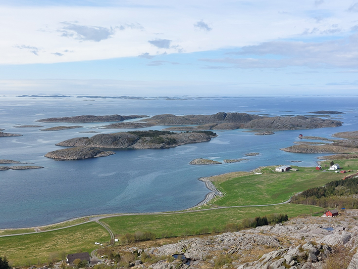
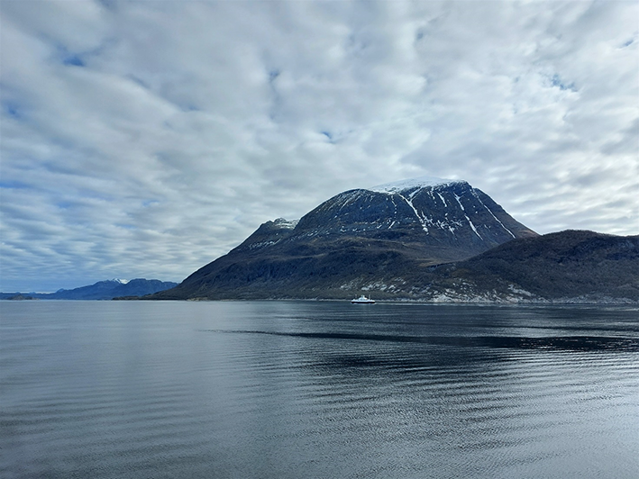
Only few islands are inhabited in the municipality of Vega, and many of them are part of the World Heritage Area. Photograph of Sundsvoll on the western coast of the island of Vega.
Photo: Julien Lebel.
From being a small-scale business in the 1960s, salmon farming has become a major national industry and a significant actor on the world market. The seafood industry is one of Norway's most important regional industries and is of great importance for value creation and employment in rural areas; Nordland/Helgeland is a key area (Bjørkan & Eilertsen, 2020). In 2020, the total value creation in Norway from the seafood industry was 112 billion Norwegian kroner (Johnsen et al., 2021). This includes fishing, aquaculture, suppliers, and sales activity. Farmed salmon is a highly industrialized activity, and a priority for Norwegian government’s ‘blue growth’ strategies. The seafood industry is also emphasised for its potential to counteract depopulation and recession in coastal municipalities. In this context, Lovund, an island in the municipality of Lurøy, is often the centre of attention. While there are international giants in the area, such as MOWI, several of the salmon farms have strong local ownerships with regional roots (Bjørkan & Eilertsen, 2020; Rybråten et al., 2018).
2.2.1 Population and geography
Both Lurøy and Vega municipalities recorded a continuous population decline following the industrial development of larger urban centres. This was especially true in Mo i Rana, as mines were opened during the first half of the twentieth century. The development of the iron and steel industry in the region after the Second World War led to significant demographic changes in Helgeland. Many fishermen and farmers left their local communities to settle down in growing cities, where a new workforce was needed. This new industry was also an important driver for population centralisation in specific urban locations, while other areas, especially coastal communities, began to experience a significant population decline.
Data from Statistics Norway illustrates the continuous population decline that characterised both Lurøy and Vega after the Second World War (Figure 2.1). In the past 35 years, the population has decreased by 23% in Lurøy (a loss of 559 inhabitants) and by 28% in Vega (a loss of 479 inhabitants). In the latter municipality, the number of inhabitants has been halved between 1950 and 2020. In small coastal communities, such numbers have a significant impact and are noticeable in the daily life of the residents.
Figure 2.1: Population development in Lurøy and Vega between 1891 and 2021.
Source: Data from Statistics Norway (ssb.no). Population counts were carried out sporadically before 1950.
Lurøy municipality is composed of numerous islands, as well as a coastal area on the mainland (see Map 2.1). While its population is spread across several locations which are not well connected, the island of Lovund constitutes the main population centre of the municipality, with numerous workplaces and diverse economic activities. However, the municipal office is located on another island, Onøya, about 20 km by boat from Lovund, but only a few kilometres from the mainland. Thus, the municipality of Lurøy is a complex geographical entity characterised by strong differences among its various settlements, because of the differentiated development of local activities and the concentration of services in specific settlements. While Lovund is described as a dynamic centre at the municipal level (Schmidt et al., 2011), other small communities in the neighbourhood struggle with strong depopulation and job losses.
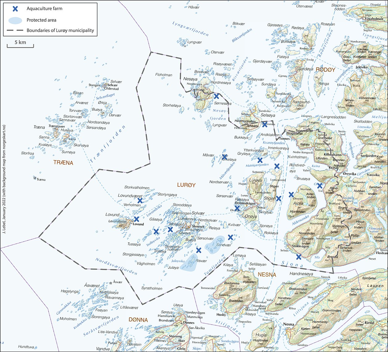
Map 2.1: Map of Lurøy municipality.
Source: Data from Norwegian Directorate of Fisheries (fiskeridir.no). Background map from norgeskart.no.
Located 20 km northwest of the city of Brønnøysund, the municipality of Vega is exclusively composed of islands (Map 2.2). The biggest island, which has given its name to the municipality, concentrates most of the population, infrastructure, and economic activities. The population distribution is less spread out than in Lurøy, since the large majority of the inhabitants live on the same island. The town of Gladstad, which is centrally located on Vega, constitutes an administrative- and service-oriented community. A few other settlements are located on the island’s seaside and are easily reachable from Gladstad by road. These settlements were traditionally devoted to fisheries activities and are important entry points when travelling to/from Vega by ferry (Gardsøy, Igerøy, Rørøy). Some other islands within the municipality have small settlements, but their number has sharply declined in the last decades: 20 islands were populated until the 1970s, as contrasted with only 4 today (Bjordal, 2013). In comparison to Vega, Lurøy has a limited area which is classified as protected. In such areas human activities are strictly regulated, if not forbidden, especially when it comes to the exploitation of marine resources.
Due to its inclusion on the UNESCO World Heritage list in 2004, the archipelago of Vega has experienced a very limited development of aquaculture installations, as the Norwegian authorities are cautious about granting authorisations in the area. However, the expansion of some aquaculture farms was contested because of their location within a World Heritage area. The fact that neighbouring municipalities are generating substantial incomes from aquaculture activities (Bjørkan & Eilertsen, 2020), which allows them to invest in local development, has provoked some debate.
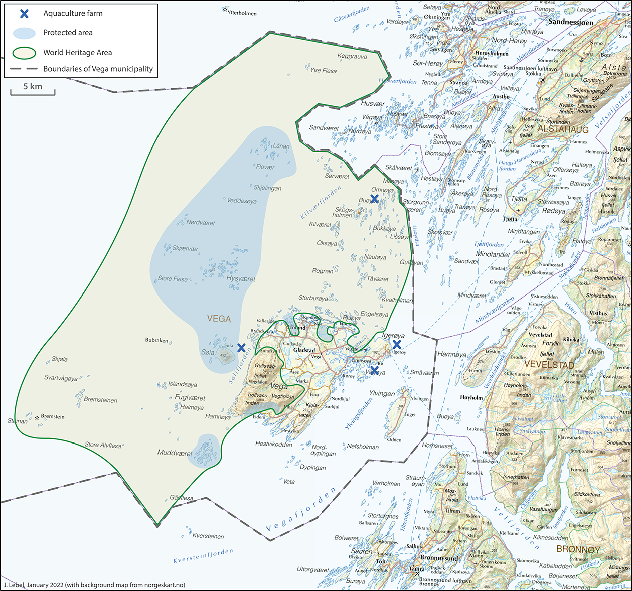
Map 2.2: Map of Vega municipality.
Source: Data from Norwegian Directorate of Fisheries (fiskeridir.no) and Vega Archipelago World Heritage. Background map from norgeskart.no.
2.2.2 Transport infrastructure and services
Due to their geographies, both Lurøy and Vega are highly dependent on port infrastructure and ferry services to ensure communication among the islands and with the mainland. Thus, such connections have an essential role in local communities located in the area. Ferry routes offer the possibility to travel to a workplace on another island or on the mainland, but also to access different services that do not exist in small settlements, like hospitals, higher education institutions, or specific administration services. As the mainland infrastructure crossing Helgeland (Nordland railway and European road E6 between Trondheim and Bodø) do not reach the coastal area, ferry services have an important position to offer attractive alternatives. This is particularly true for the long-distance coastal ferry route operated daily by Hurtigruten (Bergen-Kirkenes) which calls at Brønnøysund, Sandnessjøen and Nesna (Map 2.3). The daily rapid boat service between Sandnessjøen and Bodø, which directly serves the municipality of Lurøy at Stokkvågen and Tonnes, is also important, as it provides the possibility to reach major regional centres directly.
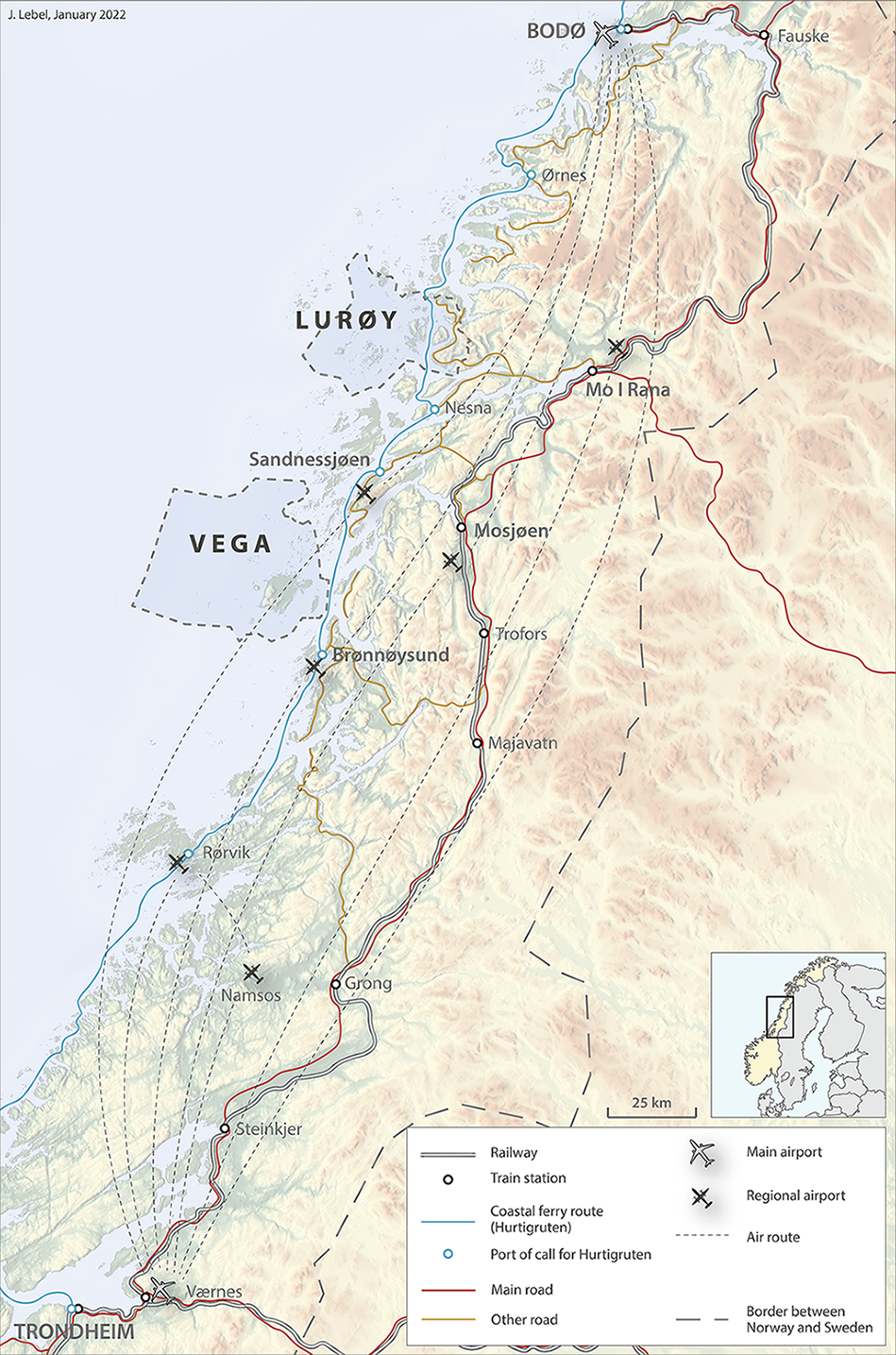
Map 2.3: Position of the municipalities of Lurøy and Vega on the Helgeland coast.
Source: Data from Bane NOR (banenor.no), Avinor (avinor.no) and Hurtigruten (hurtigruten.no).
Local ferry connections are also available to reach the mainland in both municipalities. Stokkvågen constitutes an important transit point in Lurøy, from which it is possible to reach Mo i Rana by car or bus. A daily rapid boat service also operates to Nesna and Sandnessjøen on the mainland, and to the neighbouring archipelago of Træna. This rapid boat service calls on a few islands in Lurøy, including Lovund. In Vega, a daily rapid boat service connects the northern part of the main island (Gardsøy) with Sandnessjøen, while regular ferry services are operated between Igerøy (a settlement located on the northeaster part of Vega Island) and Horn, a few kilometres north of Brønnøysund. They complement rapid boat services connecting Rørøy (east of Vega Island) directly to Brønnøysund. It is also worth noting that some bus services are available on the main island of Vega, but buses only run on the mainland in Lurøy (Tonnes-Stokkvågen-Mo i Rana).
The population of the municipality of Lurøy is spread on several islands and a coastal area on the mainland. Ferry services have a significant role by connecting the different parts of the municipality. Photograph of Aldra island.
Photo: Julien Lebel.
Airports in Sandnessjøen and Brønnøysund are the closest ones to Lurøy and Vega, offering direct flights to Bodø and Trondheim. The building of a new airport in Mo i Rana, which is scheduled to open in 2025, is expected to bring new opportunities to the region. Businesses in Helgeland are particularly interested in this airport, as it could facilitate export activities and contribute to tourist development in the region. Other interested parties emphasised that the new infrastructure may threaten the future of smaller airports in the region, as air passenger flows may be channelled via Mo i Rana. However, Avinor, the airport operator, which is owned by the Norwegian government, has maintained that it does not intend closing any of the regional airports in Helgeland.
Upgrading the Nordland railway is also closely monitored, as it is expected to boost rail services in the coming years. However, to fully benefit Lurøy and Vega, rail connections must be coordinated with bus services running between rail stations and coastal cities served by ferry links. The opening of tunnels has eased land connections between Sandnessjøen and Mo i Rana for example, but good and efficient coordination between different transport modes is often lacking in Northern Norway (Olsen et al., 2021).
2.3 Population structure and change
Data from Statistics Norway show that both Lurøy and Vega municipalities have undergone population declines of 10% and 15% between 2000 and 2020 (Figure 2.2). In the meantime, population in Norway has grown by almost 20%, and in the county of Nordland by less than 1%. Such a trend has also been underlined as a major challenge in previous studies focusing on coastal communities in the region, especially the municipalities of Lurøy and Vega (Harvold, 2009; Schmidt et al., 2011). However, there has been some stabilisation in Lurøy during the past decade, and more moderate decline in Vega.
Figure 2.2: Population development in Lurøy and Vega between 2000 and 2020.
Source: Data from Statistics Norway (ssb.no).
Such a development suggests problems for these coastal communities. In the meantime, urban centres in the region have strengthened their position by gaining population. However, trends are not uniform in these coastal municipalities; while the island of Lovund has gained new residents and improved its economic activities, other settlements in Lurøy municipality have experienced a significant population decline (Schmidt et al., 2011). A similar trend can be observed in Vega, as several islands are not populated anymore (Bjordal, 2013).
A form of centralisation is also noticeable at the municipal level which weakens peripheral settlements, as they do not benefit from the same levels of services. This is particularly noticeable in terms of transportation, not only to the mainland, but also to the economic and/or administrative centre(s) within the municipality. In Lurøy, the township of Tonnes is a good example of this problem. Even though the settlement is situated on the mainland and has a direct road connection to Mo i Rana (the main urban centre in Helgeland), Tonnes struggles with a lack of attractivity and does not experience an economic life as dynamic as in Lovund. Direct ferry connections to both Lovund and Onøya (where the city hall is located) do not exist, marginalising Tonnes further within the municipality.
Population structure has undergone major evolutions between 2000 and 2020 in both Lurøy and Vega, and the growing proportion of older people constitutes a major challenge for the sustainability of these coastal communities. The evolution of the age pyramid in Lurøy shows that people between the ages of 50 and 80 form a growing segment in these communities, while the number of younger residents has declined (Figures 2.3a and 2.3b).
In Vega this pattern is even more distinct, with an obvious gap between the ages of 20 and 45, while the development of aquaculture has attracted some younger people to Lurøy. The underrepresentation of younger people in Vega is associated with a sharp decrease between 2000 and 2020 in the number of children (Figures 2.3c and 2.3d).
Also, there are a greater number of men compared to women in several age categories, a phenomenon that can be explained by the importance of the fishery sector, which traditionally employs men. Another gender dimension element is the possibility that more women migrated out of the local community. Data from Statistics Norway (SSB) show that about 30% of women and 15% of men who are registered as residents in Lurøy or Vega have a university degree. This partly illustrates the fact that many women emigrate to study longer and that their job prospects are more dependent on formal education.
2.3.1 Migration and labour markets
Data regarding birth surplus[1]Birth surplus, also called natural change in demography, is the difference between the number and births and number of deaths in the population. If the number of births is greater than the number of deaths, then birth surplus is positive. and net migration are characterised by important variations from one year to another in Lurøy (Figure 2.4a). We may observe that less dramatic numbers have been recorded during the previous years with regard to net domestic migration, even though the trend is still negative for domestic migrants. Birth surplus tends to be negative most years, probably as a result of the negative trend regarding domestic migration. As many young adults leave the community to start studying and/or getting new job opportunities, they do not contribute to population increase in the municipality as they eventually settle down and have children in another location. However, international migration appears as a strong factor in Lurøy. The development of the aquaculture sector has led to new job opportunities and foreigners constitute an essential workforce, mostly coming from other European countries according to the data of Statistics Norway.
Footnotes
- ^ Birth surplus, also called natural change in demography, is the difference between the number and births and number of deaths in the population. If the number of births is greater than the number of deaths, then birth surplus is positive.
Figure 2.4a: Population changes per year in Lurøy between 2002 and 2020: birth surplus, net domestic migration and net international migration.
Source: Statistics Norway (ssb.no).
Net migration is also characterised by strong variations in Vega, while birth surplus stays clearly negative (Figure 2.4b). This is an obvious consequence of the structure of the population that is described above, as the municipality lacks residents who are in the childbearing years. However, net international migration has never been negative the past 20 years, even though population gains from this category are less substantial than in Lurøy. These new residents come from a large variety of European countries and include refugees from Somalia, Eritrea and Syria.
Figure 2.4b: Population changes per year in Vega between 2002 and 2020: birth surplus, net domestic migration and net international migration.
Source: Statistics Norway (ssb.no).
The labour market in Lurøy is characterised by the strong position of the industrial and fishery sectors as the main sources of jobs, which reflects the development of local companies specialised in fish farming (Figure 2.5a). Activities focusing on trade, tourism and transport are also well represented. The large majority of adults living in Lurøy have their workplaces within the municipality. Only 29 people from Lurøy were working in Rana municipality in 2020, while there were more than 50 in 2000, according to Statistics Norway (ssb.no). This reflects a growing number of local job opportunities, but it may also be explained by the challenges linked to commuting to another municipality, especially when using ferry services.
Figure 2.5a: Labour market in Lurøy in 2008 and 2020.
Source: Statistics Norway (ssb.no).
Agriculture, fisheries, trade, hospitality and transport, along with social services and healthcare, also provide most of the workplaces in Vega (Figure 2.5b). Between 2008 and 2020, the total number of employees has declined, a pattern which reflects the loss of residents that was observed above. Statistics from Statistics Norway (sss.no) indicates that most residents working outside Vega municipality have their workplace located in Brønnøysund (almost 50 people, both in 2000 and 2020).
Figure 2.5b: Labour market in Vega in 2008 and 2020.
Source: Statistics Norway (ssb.no).
As the fishery historically constituted a significant sector of activity in both Lurøy and Vega, it is relevant to look at the evolution of the number of registered fishermen/women between 1985 and 2019 (Figure 2.6). A strong decline can be observed in both cases. While the number of fishermen/women (main occupation) only slightly decreased in Vega since 2005, it has been halved in Lurøy between 2005 and 2019. This coincides with the strong development of aquaculture in Lurøy. Fishermen/women regularly voice their concerns regarding the decline of fish stocks in specific areas, arguing that the expansion of aquaculture installations has negative effects (Rybråten et al., 2018; Bjørkan & Rybråten, 2019).
Figure 2.6: Registered fishermen/women in Lurøy and Vega between 1985 and 2019.
Source: Norwegian Directorate of Fisheries (fiskeridir.no).
Even though Nordland county has a parallel decline in fishermen/women (main occupation) between 1985 and 2019 at -62%, the pattern has been much sharper in Lurøy and Vega (respectively, -75% and -82%).
2.4 Municipal structure 2000–2020
Municipalities are often perceived as ‘the very foundation of [Norwegian] democracy’ and are important for the administration of public welfare schemes (Hansen & Thorsnæs, 2019). Municipalities have several important roles: as authorities, service providers, facilitators, promoters, and owners. Their main responsibilities lie in the social, health, education and technical areas (Thorsnæs & Berg, 2021). They also have central roles as planning authorities and are responsible for emergency preparedness.
Local governance and municipality size are issues that engage the Norwegian populace both at the local and central levels. There are two considerations that have determined municipality size through the years: 1) the consideration that municipality size should be small enough to reduce the distance between politicians and the citizenry, thus encouraging citizen’s engagement in the democratic process, and 2) that the municipalities should have the size and capacity to ensure reliable access to services. This second proposition is sometimes used as argument for merging municipalities to increase their size and create robust public service offers. These considerations have animated the debate regarding municipality size and structure and inspired several restructuring processes (Hansen & Thorsnæs, 2019).
Norwegian municipal structure has changed several times in the last couple of centuries. The most recent restructuring was in 2017, when the Norwegian government merged some municipalities and reduced their number from 426 to 358. This was done to ensure more efficient local services and better economic resources for the municipalities. This decision was criticized for weakening local democracy, as municipalities constitute the political level that is the closest to the citizens in Norway. Covering relatively large areas, the coastal municipalities often gather numerous islands that are more or less well-connected with each other. The development of different transport infrastructures, along with the constant adjustment of transport networks, led to significant differences in terms of accessibility and connectivity among the different parts of the same municipality. The case of Lurøy is particularly interesting, as the municipal boundaries do not only include islands, but also a part of the mainland with a few small settlements. This constitutes an obvious challenge to guarantee cohesion within the municipality.
Even though the municipalities of Lurøy and Vega include many islands, only a few of them are currently inhabited. Yet, the distance separating the different settlements implies that the residents do not enjoy the same accessibility to specific services. While several islands lost their inhabitants over the past few decades in Vega, population has clustered on the main island, where Gladstad constitutes the administrative and economic centre of the municipality. However, in Lurøy the situation is quite different; most of the economic activities have developed in Lovund, which is located on the island most distant from the mainland. The expansion of aquaculture installations in the surrounding areas has strengthened the position of Lovund since 2000. However, most of the administrative services are still found on Onøya, an island located a few kilometres away from Stokkvågen, a small settlement on the mainland that constitutes an important transit point within the municipality.
2.5 Assessment of main changes in Lurøy and Vega
The first aquaculture activities were established in Lurøy in the 1970s as secondary occupations (Schmidt et al., 2011). The sector expanded through local companies, and Lurøy is now an important aquaculture centre for the whole region. Even as major aquaculture companies in Northern Norway, some still have their main offices located in the municipality, and they are characterised by narrow ties with the local community through the involvement of local stakeholders in their ownership. Thus, the aquaculture sector in Lurøy still contributes to the development of the municipality, and especially the township of Lovund. Thanks to the growth of aquaculture, the municipality benefits from significant incomes and has expanded local services to maintain existing residents, and attracted new ones (Schmidt et al., 2011). But the municipality of Lurøy, and particularly the township of Lovund, constitutes a special case, rather than an example for coastal communities in Northern Norway.
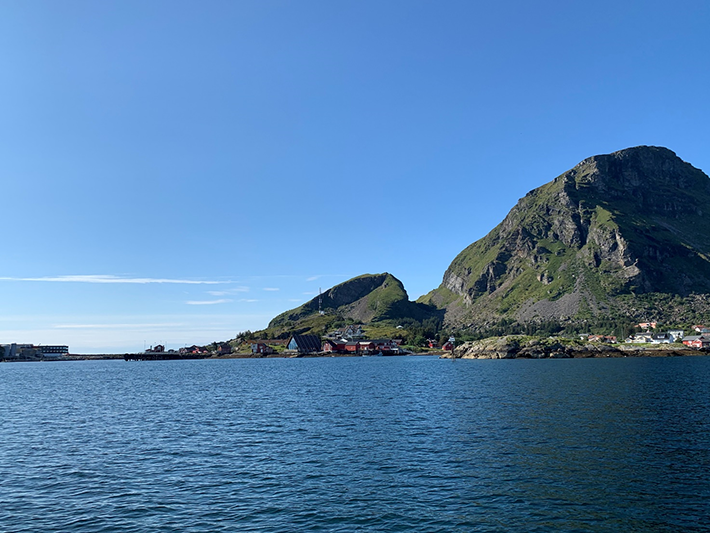
The township of Lovund is an important aquaculture centre in Northern Norway.
Photo: Maiken Bjørkan.
The expansion of tourism in Vega mostly resulted from the inclusion of the archipelago on the UNESCO World Heritage list in 2004. While there were 5,000 visitors in 2005, their number increased sharply to reach about 40,000 in 2018 (Hansen, 2019). This has resulted in the opening of new accommodations for tourists, along with the development of leisure activities focusing on nature and local traditions. While land and sea resources historically had a central position in Vega, the establishment of a World Heritage area comprising some highly protected areas resulted in limitations to develop the “blue economy” in Vega. As tourism is mostly a seasonal activity, less stable job opportunities than in Lurøy emerged, which did not fully contribute to the settlement of a significant number of new residents. However, the development of tourism drove some actors involved in land use and fisheries to refocus their activities to create products for visitors, while adjusting their activities to make them accessible to tourists willing to discover more about the archipelago and its traditions.
2.5.1 Inhabitants’ perceptions of their local context and expectations for the future
To assess the perceptions of the inhabitants of Lurøy and Vega municipalities, a survey by telephone in the period 12–16 May 2021 was conducted which involved adults over 18 years of age.[1]The survey was conducted by the company Polarfakta (www.polarfakta.no). In total, 250 individuals took part in the survey, while 315 turned down the invitation to participate, for a response rate of 44,2%. The majority of the respondents in both Lurøy and Vega were male (ca. 60%) and all adult age groups were represented in the survey. A significant majority (88%) have an education level that is highschool and higher. Close to 30% have a university or higher education levels. Most of the respondents (88%) were born in Northern Norway, while the remainder moved to the region from other parts of Norway or abroad (0.8%). About 59% of the respondents are involved in the market economy. About 47% are either full- or part-time employees, and 10% have own business, while 2% are unemployed. The remaining 41% are outside the labour market as pensioners (34%), disabled (6%) or homemakers (1%). For those economically active, the most important sectors are agriculture, hunting, forestry and health and social services. About 9% work in fisheries, 8% in aquaculture, 9% in manufacturing activities and 8% in education. Although high completion rates of high school students are not surprising for Norway, we acknowledge that different factors could influence response rates including education levels. The Research Council of Norway has indicated that response rates to surveys have declined in Norway in the past years (from around 70% in the 1980s to 40–50% in recent years) and this could introduce bias in the surveys. We also acknowledge that education levels and other respondent characteristics have been shown elsewhere to influence response rates of surveys. As we have not analysed the characteristics of those that turned down the invitation to participate in our survey, we cannot be absolutely certain that there is not bias in the findings. We suggest that the reader should keep this in mind while reading the chapter. The survey was inspired by quality-of-life research, which evaluates people’s evaluations of their own lives, main domains of life (such as work, education, family life, and the like), and their community. People’s evaluation of their own lives is measured by the life satisfaction indicator which represents a score people give to the level of satisfaction with their lives. The question is often represented by a ‘Cantril ladder’ where people are asked to assign a score on a range from zero at the lowest level (the worst possible life) to ten at the top (the best possible life) (Diener, 1984; Diener & Ryan, 2009). This indicator is widely used in national and international statistics.
Our survey covered the following areas: people’s evaluations of their lives (life satisfaction), what they consider to be an ideal municipality, how their municipality compares to this ideal municipality, their expectations for the future, the changes they observe in their municipality, their assessment of the economy, and risks/threats to their municipality.
Respondents in both municipalities report high levels of life satisfaction. Over 80% of the respondents in both Lurøy and Vega give a score of eight and higher on the life satisfaction question. Over 55% give a score of nine or ten. This is significantly higher than the national pattern, where only 21% have the same high scores (data from Statistics Norway, SSB). Respondents also give high scores (more than eight) to their satisfaction with the economic situation in their household, their jobs, social relations, and local community. The only category where they give a low score is access to jobs in the local community, reflecting both the lack of jobs and the lack of interesting professional opportunities. In this regard, respondents from Vega give the lower score at 5.5, while in Lurøy, the score is 6.9.
In both Vega and Lurøy, access to nature is seen as an important amenity of an ideal municipality. It is by far the dimension that received the highest score (9 out of 10) on survey participants’ rankings. Good social services (school, healthcare), good local social relations where people help each other, and access to work are also perceived as essential aspects (all scoring 8.8 and higher out of 10). In comparison with other age categories, young adults (18-34 years old) consider leisure activities, the possibility to influence decisions affecting their daily life, and access to social meeting places as more important factors to characterise an ideal municipality.
In both Lurøy and Vega, the residents are satisfied with the way they can access and spend time in nature. They are, however, quite critical of shops, housing, and public transport. Young adults are notably much less satisfied than other age categories when it comes to available leisure activities and shops, access to housing, public transport, and social meeting places (all scoring 5 or lower out 10). In general, people are more satisfied in Vega than in Lurøy. This can be explained by the fact that most of the inhabitants in Vega live on the same island, which means that they can access different local services more easily. Moreover, the inclusion of Vega archipelago on the UNESCO World Heritage list has very likely influenced positively the perception of local residents about the nature and landscape existing around them. Residents in Lurøy are more positive about jobs than in Vega. This could be the consequence of extensive fish farming in Lurøy, which has created new jobs.
Housing, public transport and job markets are areas registering the biggest gap between expectations and the current situation in both municipalities. Despite dissatisfaction regarding specific topics, a large majority of the respondents indicate that they would not move from Lurøy/Vega. More residents in Lurøy (85%) are confident about the future than in Vega (71%). Similarly, more respondents in Vega (87%) see emigration of youth as a threat than in Lurøy (78%). This could be because the stronger economy in Lurøy, and the recently established local services in Lovund, can attract and absorb more workers than in Vega. Young adults are more positive about the future of their local community than other age groups, but they perceive emigration as a bigger threat than other groups.
About 63% of the population in both municipalities have a positive view of the development in their communities over the last 10 to 20 years. More than half of the respondents in both municipalities say that services from schools, kindergartens, and health services have become better. Two areas where respondents do not see equivalent improvements are cultural life and community cohesion. Respondents in Lurøy are more dissatisfied with cultural life than in Vega. In Lurøy, 39% say that cultural life has become worse; 29% say that it has not changed, while 21% say that it has improved. In Vega, 46% say that cultural life has become better, but 21% disagree and say that it has become worse. About 31% say that it has not changed. The evaluations of community cohesion are not too different in the two communities. About 30% say it has become worse (30% in Vega, 28% in Lurøy), 40% say that there is no change (39% in Vega, 37% in Lurøy) and 30% say it has improved (28% in Vega, 31% in Lurøy).
There is a clear difference between the two communities in perceptions of changing lifestyles. More respondents in Vega (68%) state that lifestyles have changed in the last 10 to 20 years, while fewer people in Lurøy (42%) think the same. On questions of what aspects of the lifestyle have changed in Lurøy and Vega, the following answers were more frequent: less social (21), better economy (17), travel more (16), and more active (9). The development of tourism in Vega and the concentration of the whole population on a more limited number of islands may explain such perceptions. However, the expansion of aquaculture may be perceived by some of the inhabitants in Lurøy as a natural continuation of a historical focus on ocean resources.
A large majority of residents in both municipalities (88%) think tourism has had a positive impact on their local communities. This sentiment is slightly stronger in Vega (90%) than in Lurøy (86%). The disposition switches when it comes to aquaculture and fisheries. In Vega, two-thirds of the respondents see the positive influence of fisheries (61%) and aquaculture (67%). In Lurøy, the percentages rise considerably. About 90% state that aquaculture has positively influenced their community, while 82% state the same for fisheries. There is, however, some scepticism about these activities among respondents in Vega. About one in three do not see any positive influence from these activities on the local community. Not surprisingly, more residents in Lurøy than in Vega want the municipality to focus more on aquaculture. In a similar way, residents in Vega state that they would rather see more focus on tourism from the municipality.
In both municipalities, emigration of young people is considered as the biggest threat. Centralisation of economic resources, and political and economic power, are also ranked high in a list of threats, in addition to the lack of transport and work alternatives. Environment problems are not considered among the biggest threats.
Footnotes
- ^ The survey was conducted by the company Polarfakta (www.polarfakta.no). In total, 250 individuals took part in the survey, while 315 turned down the invitation to participate, for a response rate of 44,2%. The majority of the respondents in both Lurøy and Vega were male (ca. 60%) and all adult age groups were represented in the survey. A significant majority (88%) have an education level that is highschool and higher. Close to 30% have a university or higher education levels. Most of the respondents (88%) were born in Northern Norway, while the remainder moved to the region from other parts of Norway or abroad (0.8%). About 59% of the respondents are involved in the market economy. About 47% are either full- or part-time employees, and 10% have own business, while 2% are unemployed. The remaining 41% are outside the labour market as pensioners (34%), disabled (6%) or homemakers (1%). For those economically active, the most important sectors are agriculture, hunting, forestry and health and social services. About 9% work in fisheries, 8% in aquaculture, 9% in manufacturing activities and 8% in education. Although high completion rates of high school students are not surprising for Norway, we acknowledge that different factors could influence response rates including education levels. The Research Council of Norway has indicated that response rates to surveys have declined in Norway in the past years (from around 70% in the 1980s to 40–50% in recent years) and this could introduce bias in the surveys. We also acknowledge that education levels and other respondent characteristics have been shown elsewhere to influence response rates of surveys. As we have not analysed the characteristics of those that turned down the invitation to participate in our survey, we cannot be absolutely certain that there is not bias in the findings. We suggest that the reader should keep this in mind while reading the chapter.
2.6 Preliminary conclusions on the resilience of coastal communities
The coastal communities of Lurøy and Vega have undergone major changes over the past few decades. Established families of fishermen and farmers no longer constitute the core of local activities, as new contexts have emerged, leading to new opportunities and challenges. Aquaculture and activities relating to the ‘blue economy’ have grown in Lurøy, which has favoured the development of Lovund as the demographic and economic centre of the municipality. UNESCO’s classification of a large part of the Vega archipelago on its World Heritage list has boosted the development of tourism in the area. UNESCO’s listing also aims to safeguard some local traditions in Vega, particularly the harvesting of eider duck down. However, the UNESCO listing has limited development of aquaculture in Vega. In the meantime, land use activities, like milk production and pig farming, are well established in Vega. In some cases, these activities attract tourists willing to buy and consume local products.
Even though new economic opportunities arose from recent transformations, some significant challenges remain. First, dynamics are not uniform within those municipalities, as some areas strengthened their positions by gaining new residents and workplaces, whereas others are struggling to maintain a local community. This is underlined in both case studies as several islands have been depopulated, a trend which is associated with centralisation at the municipal level.
An ageing population, and important gaps between age classes, are also a source of concern. Yet, negative trends regarding population development over the past few decades must be analysed carefully: there are strong variations from one year to another, and the settlements within the municipalities do not have identical trajectories. Still, the lack of young families is an obvious concern for sustainable development in these communities. In turn, the relative absence of young families impacts local public services, like schools and healthcare services.
These social changes have promoted a more specialized workforce, along with transformations for local value chains, and a broader reliance on actors located outside of the region. While the domestic migration balance and birth surplus are characterised by negative trends in both municipalities, international immigration counterbalances these shifts. This is particularly the case in Lurøy, due to the development of aquaculture installations. However, a challenge will be to ensure that those new residents settle with their families and stay in the communities over time. Population retention requires attractive public services, dynamic social and cultural life, and efficient transportation connections. While Lovund seems to constitute an interesting example, many challenges remain in most of coastal communities in Northern Norway.
Access to suitable housing is a particular concern for young families, while the development of vacation housing dedicated to tourism and seasonal visitors impacts the market. The lack of reliable and expanded communication and transportation connections also harms local development and poses challenges for established companies. This is particularly true in municipalities like Lurøy and Vega, due to their reliance on ocean transportation for connections to the mainland, and essential services in bigger cities, like high schools, hospitals, and airports. Moreover, the lack of internal communication links among the different islands in these two municipalities also promotes centralization, as few settlements benefit from the best connections with the mainland.
This centralisation trend at the municipal level is certainly having important impacts on coastal communities that would need to be studied more closely, especially to understand how this could contribute or not to sustainable development in the long term. In the meantime, concerns from regional and national authorities willing to ensure efficient and cost-effective transportation services, have obvious consequences for the development of local communities like Lurøy and Vega. It may be necessary to adopt a new approach to transport connections to and from such communities, and to focus on the way to develop them in a more sustainable way.
Finally, many residents underline the need to guarantee good internet connections, especially as many activities depend on partners located outside of the municipalities, and tourism agents need to promote their products to visitors coming from other locations. With the pandemic stimulating the development of remote working locations and home offices, good and reliable internet connections are necessary to establish local communities as a suitable environment for both living and working. This factor could also lead to an evolution of the position of coastal communities, by contributing to restraining, if not reversing, negative demographic trends in the future.
References
Bjordal, K. (2013). Verdensarv en ny giv for Vega? En casestudie om effekter av en verdensarvstatus. Master’s thesis in Archeology, Universitetet i Oslo.
Bjørkan, M. & Eilertsen, S. V. (2020). Local perceptions of aquaculture: A case study on legitimacy from northern Norway. Ocean and Coastal Management, 195, 105276. doi:10.1016/j.ocecoaman.2020.105276
Bjørkan, M. & Rybråten, S. (2019). The potential impact of sea lice agents on coastal shrimp in Norway: risk perception among different stakeholders. Maritime Studies, 18 (2), 73-187.
Brox, O. (1966). Hva skjer i Nord-Norge? Pax.
Diener, E. (1984). Subjective well-being. Psychological Bulletin, 95(3), 542-575.
Diener, E. & Ryan, K. (2009). Subjective Well-Being: A General Overview. South African Journal of Psychology, 39(4), 391-406. doi:10.1177/008124630903900402
Hansen, E. C. (2019). Ansvarlig reiseliv i spenningsfeltet vern og utbyggingsinteresser. En studie av reiselivsutvikling i verdensarvområdet Vega. Master’s thesis in community planning and cultural understanding, Norges arktiske universitet.
Hansen, T. & Thorsnæs, G. (2019). Kommuneinndelingen i Norge. In E. Bolstad (Ed.), Store norske leksikon. https://snl.no/kommuneinndelingen_i_Norge.
Harvold, K. (2009). Befolkningsutvikling på Smøla og Vega. NIBR-notat 2009:101. https://oda.oslomet.no/oda-xmlui/bitstream/handle/20.500.12199/2265/2009-101.pdf?sequence=1&isAllowed=y
Helland, A. (1907). Topografisk-statistisk beskrivelse over Nordlands Amt. Første del. Den almindelige del. Aschough & co.
Johnsen, P. F. F., Erraia, J., Grønvik, O., Fjose, S., Blomgren, A., Fjelldal, Ø., Robertsen, R., Iversen, A. & Nyrud, T. (2021). Ringvirkninger av sjømatnæringen i 2020. Menon Publikasjon nr. 105/2021. https://nofima.no/wp-content/uploads/2021/11/Rapport-Ringvirkninger-av-sjomatnaeringen-i-2020.pdf
Knudsen, J. P. (2018). Vicarious habitation - reinterpreting the role of peripheral living in a Nordic context. European Planning Studies, 26(2), 279-296. https://doi.org/10.1080/09654313.2017.1361589
Meld. St. 18. (2016–2017). Urban sustainability and rural strength – in brief. https://www.regjeringen.no/contentassets/d15e0f19e7d9439ea5c1b08ba888bdd1/en-gb/pdfs/stm201620170018000engpdfs.pdf
Olsen, J., Antonsen, K., Lebel, J., Wigger, K., Heemstra, H. H. & Nenasheva, M. (2021). Samordning av lokale og turistrelaterte transportbehov. NF rapport nr: 12/2021. https://www.nordlandsforskning.no/nb/publikasjoner/report/samordning-av-lokale-og-turistrelaterte-transportbehov
Rybråten, S., Bjørkan, M., Hovelsrud, G. K. & Kaltenborn, B. P. (2018). Sustainable coasts? Perceptions of change and livelihood vulnerability in Nordland, Norway. Local Environment, 23(12), 1156-1171.
Schmidt, L., Stokke, K. B., Onsager, K., Gundersen, F. & Sørlie, K. (2011). Livskraftige kystsamfunn. Steds- og næringsutvikling i Lurøy kommune, med hovedvekt på Lovund. NIBR-rapport 2011:30. https://oda.oslomet.no/oda-xmlui/bitstream/handle/20.500.12199/5564/2011-30_web.pdf
Sundsvold, B. (2015). Den Nordlandske Fuglepleie – Herligheter, Utvær og Celeber Verdensarv. Mellom tekster og praksiser i Vegaøyan. PhD, Norges arktiske universitet. https://munin.uit.no/handle/10037/8457
Thorsnæs, G. & Berg, O. T. (2021). Kommune. In E. Bolstad (Ed.), Store norske leksikon. https://snl.no/kommune
Wold, H. A. (1985). Kystfolk og sjøfugl. Tromsø Museum, Nordkalottmuseet.
Chapter 3: Structural changes and how they are perceived in two Icelandic towns
Grétar Þór Eyþórsson & Sigríður K. Þorgrímsdóttir
3.1 Introduction
In this chapter, we want to investigate the social and economic development in the two towns of Siglufjörður and Ólafsfjörður in north Iceland, primarily after the year 2000. We will look at how these two communities, which faced great changes when they were amalgamated as the municipality of Fjallabyggð in 2006, took different economic development trajectories. We will explore how the people of the two fishing towns managed to adapt to major changes initiated by the state authorities and later by private initiative through large investments in tourism and biotechnology. These changes occurred in the context of a road tunnel being constructed between the two towns in in 2010.
The key question is: Has the community created by the two towns demonstrated resilience in transforming from traditional Icelandic fishing towns into a community that is more characterised by tourism and the knowledge industry? Resilience is defined as “the capacity to cope with change and continue to develop” (Giacometti and Teräs, 2019, p. 11). A further definition talks about resilience as the ability of a local or regional community to recover from natural disasters, or to anticipate global trends that may present challenges to local industries, jobs and communities. These risks may include the automation and decarbonisation of the energy sector or, from a local perspective, trends such as an ageing population or demographic decline (Giacometti & Teräs, 2019). Some of these circumstances existed in Siglufjörður and Ólafsfjörður prior to 2000, even though the communities did not suffer from major problems. Saarinen and Gill (2019) point out that the specific contribution of the resilience idea is to focus attention on a systems or communities’ capacity to absorb disturbance through reorganisation. Dredge (2019, p. 53) emphasises “…decoding the sustainability challenge into smaller adaptive actions that allow socio-ecological systems to rebalance and cope with change”. Clifton (2010) makes a distinction between engineering-resilience and socio-ecological resilience. In contrast to engineering-resilience, socio-ecological resilience is concerned with maintenance of system function, self-organisation, learning, and adaptation. It sees socio-ecological-systems as having many possible functional states, and subject to natural variability, change, and unpredictability (Holling, 1996). For socio-ecological resilience, thresholds are paramount and, rather than being focused only on bounce-back, are concerned with increasing the likelihood that a socio-ecological-system does not breach thresholds that move it into an undesirable regime, especially one from which it may not be able to recover (Walker & Salt, 2006). In our study we shall focus on how these communities managed to adapt to the changes they went through with the decline of traditional fisheries and growth of tourism and innovation in biotechnology.
We use statistical information on the towns and the municipality from Hagstofa Íslands (Iceland Statistics) and Byggðastofnun (Institute for Regional Development). But the main empirical data we use to answer our questions is from an internet-survey conducted among approximately 300 people in February 2021. The focus was on how the people of the two towns perceived these developments.
3.1.1 Earlier research on the cases
There is a considerable amount of research on the socioeconomics of the towns of Siglufjörður and Ólafsfjörður and the municipality of Fjallabyggð. A general report on the social and economic life in Eyjafjörður region was published in 2002 (Jóhannesson, 2002). There are diverse data on both towns before the amalgamation in 2006. In particular, a socio-economic impact report was done on the planned road tunnel by Jóhannesson, Eythórsson and Ólafsson (2001).
A helpful book of the impact of the Héðinsfjörður road-tunnel was published in 2021 (Bjarnason & Stefánsson, 2010). This book includes chapters in which the tunnel is related to the municipal amalgamation (Eythórsson, 2010), traffic patterns (Heiðarsson et al., 2010) and tourism (Bjarnason & Huijbens, 2015).
In 2010 – 2011 a Nordic project, Vestnorden Foresight 2030, conducted a case study in Fjallabyggð and Borgarbyggð in Iceland, as well as communities in Greenland and the Faroes. In this project the focus was on the foresight of people in these communities. In the Icelandic cases, data was collected from focus groups (Eythórsson & Karlsson, 2011; Gløersen, 2012).
These studies showed both the expected and experienced importance of the road tunnel between the towns. The Nordic study demonstrated great expectations and hopes among people for the tunnel project and the impact of amalgamation of the two municipalities. Our new study, among other things, will discuss whether expectations were fulfilled after ten years.
3.2 A socio-economic overview of the two fishing towns.
Icelanders have depended on their fisheries through the ages.[1]About the Icelandic fisheries system, see www.fiskistofa.is/english At first, fishing mostly met household needs, as the households were in the countryside, and primarily depended on subsistence agriculture, as well as the sale of wool and fish to Danish merchants. Villages were few and were mostly centred on Danish traders who had a monopoly on retail business in Iceland. Nevertheless, fishing was always important, and farmers were fishermen as well. Siglufjörður and Ólafsfjörður have been fishing towns. The natural surroundings are somewhat similar, with high, steep mountains which made travel by land difficult. The mountains fostered social isolation, even later in history when roads were built, and people stopped travelling by sea. Fishing and fish processing were the main forces creating villages, and later towns, in these places. Still, as will be discussed below, development in these two towns was somewhat different.
Footnotes
- ^ About the Icelandic fisheries system, see www.fiskistofa.is/english
The natural surroundings with high, steep mountains have made travelling and infrastructure difficult in Siglufjörður and Ólafsfjörður. Here avalanche protection above Siglufjörður.
Photo: Grétar Þór Eyþórsson.
Siglufjörður received town status in 1918, but its history goes back further. It had been a fishing place for a long time, fishing shark, among other species, in the early days. There was no Danish merchant located in Siglufjörður during the monopoly period, which ended in 1788. Siglufjörður, with 160 inhabitants, received permission for a trading place in 1818. The first traders, until 1875, were Danish (Siglfirðingablaðið, 1998).
Siglufjörður is surrounded by high and steep mountains, with almost no lowlands. Because of its surroundings, Siglufjörður was isolated, if you wanted to go by land. Since it had a good natural harbour, it was easier to get there by sea. Herring fishing and processing, led by Norwegians, began before 1900. However, when we speak of síldarárin, the herring-period, we are referring to the late 1940s to the early 1960s. During this period, the population was growing quickly; in 1950, the town was the fifth largest in Iceland, with 3,100 inhabitants. There were numerous migrant workers of both sexes in the town, with a population which reached 10 thousand people at its peak. Herring was as much as 20% of all Icelandic fish exports at one point during síldarárin. Herring-processing, salting, and smelting led to a boom in building construction. With so many people in town, expansion in services, culture, and entertainment flourished. Stories about this period are still a part of local culture; every year, there is a well-attended festival in Siglufjörður in memory of the herring period.
In the sixties the herring disappeared, and depopulation began. Capelin fishing and smelting (loðna) were substituted, using the large herring buildings for processing. Fishing with trawlers started in Siglufjörður around 1970, which coincided with the fishing and processing of prawns. But population decline continued (Figure 3.1). No population growth occurred until 2006.
Ólafsfjörður received town status in 1945, but the village had been there since the late 1800s. The place was also based on fisheries, but with no natural harbour, so conditions were poorer than in Siglufjörður. The surroundings are also different, since there is some lowland around Ólafsfjörður town which was used for farming. There, as in other parts in Iceland, farmers traditionally depended on fisheries along with agriculture. They fished from both Siglufjörður and Eyjafjörður. Around 1900 the first shipowner settled in Ólafsfjörður and built up his fishing company. Fishing became the main industry in Ólafsfjörður. However, fishing was limited by the lack of a decent harbour. The Ólafsfjörður boats had to sail from elsewhere until the harbour in Ólafsfjörður was built up in the decade after 1943 (Olgeirsson, 1991).
Figure 3.1: Population in Siglufjörður, Ólafsfjörður and (later) Fjallabyggð 1908-2021.
Source: Statistics Iceland (hagstofa.is).
Figure 3.1 clearly shows the impact of the herring-period in Siglufjörður, with its peak around 1950. The line for Ólafsfjörður is flat by comparison.
The year 1945 was, in many ways, a breaking point in the lives of the people of Ólafsfjörður. This was due to modernization in fish processing, with a fish processing factory with new technology, the new harbour, and the mechanisation of agriculture, which was still a considerable part of Ólafsfjörður’s economic life (Olgeirsson 1991).
3.2.1 Changes in transportation
Both towns, surrounded by high and steep mountains, were isolated in the past. The towns had difficulty establishing good road connections to neighbouring communities. Before 1950 there were few roads in Iceland; the national ‘circle road’ for the country was by sea.
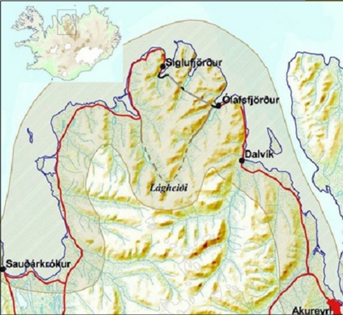
Map 3.1: Tröllaskagi peninsula and surroundings.
Source: Jóhannesson et al. 2001.
When the main ‘road’ was by sea, Siglufjörður was not more isolated than other towns in Iceland, perhaps less so because of the good harbour. When the ships/ferrys for passengers stopped sailing late in the sixties, social isolation began. Isolation occurred even though there was a road (Siglufjarðarskarð) built in 1946 because the road over the mountains was steep and rough, and open for just a few months a year. Another mountain road (Lágheiði) was built the year after, connecting Ólafsfjörður westwards. The first road tunnel to Siglufjörður, Strákagöng, an 800-metre-long tunnel, improved road connections in 1967 even though the road to Siglufjörður continued to be unstable and dangerous. In 1960 a rough road to Ólafsfjarðarmúli was opened, which made it possible to drive towards the southeast and to Akureyri, the biggest town and the service centre for north Iceland. This road was periodically closed due to frequent mud and snow slides. In 1991, the 3,4-km-long Múlagöng road tunnel to Ólafsfjarðarmúli southwards to Dalvík and Akureyri was opened. This new tunnel improved the situation for Ólafsfjörður, as residents were now able to drive to Akureyri in less than one hour. But the real change in local transport occurred in 2010, when the Héðinsfjarðargöng tunnel opened connecting the two towns. This new tunnel strengthened the new municipality of Fjallabyggð, which was created from the amalgamation of Siglufjörður and Ólafsfjörður.
3.2.2 Fjallabyggð: the 2006 amalgamation and the 2010 road tunnel
Fjallabyggð has existed as a municipality since the amalgamation of Siglufjörður and Ólafsfjörður in 2006 (fjallabyggd.is). The precondition for the merger of the two fishing towns, which had always been isolated from one other, was the construction of the 11 km long Héðinsfjarðargöng road tunnel through the mountains between them. The Héðinsfjarðargöng road tunnel brought the towns much closer to each other, and the tunnel ended Siglufjörður’s isolation. Since the autumn of 2010, the distance from Siglufjörður to Akureyri is only 77 kilometres, compared with as much as 192 kilometres before the tunnel. This is particularly important because Akureyri is the service centre of north Iceland. Even though the tunnel was not opened for traffic until October 2010, the amalgamation of the two municipalities occurred in 2006. The idea was to use the time to prepare for what was to come some years later (Eythórsson, 2010). The tunnel reduced the distance between Ólafsfjörður and Siglufjörður by 47 km for the summer, and by 217 km year around (Heiðarsson et al., 2010).
3.2.3 Demography
If we begin by looking at the population changes, we see a steep depopulation in both towns from 1981. However, the population has been stable since 2011, as shown in Figure 3.2. The depopulation in both towns stops at the same time as the tunnel opens and population has been stable since then.
Figure 3.2: Population development in Fjallabyggð, Siglufjörður and Ólafsfjörður 1981-2020.
Source: Icelandic Regional Development Institute (byggdastofnun.is) & Statistics Iceland (hagstofa.is).
For the 1981-2020 period, the reduction in population is 37% in Fjallabyggð as a whole, with significantly more depopulation in Siglufjörður than in Ólafsfjörður (table 3.1).
| 1981 | 2020 | Number | Rate | |
| Siglufjörður | 2012 | 1185 | -827 | 41,1% |
| Ólafsfjörður | 1191 | 821 | -370 | 31,1% |
| Total | 3203 | 2006 | -1197 | 37,4% |
Table 3.1: Depopulation in Siglufjörður and Ólafsfjörður 1981-2020
Source: Statistics Iceland (hagstofa.is)
Population growth for the country for that same period was 58,8%, and for north-east Iceland 19,1%. The population decline for the two towns in our study, by comparison, is quite marked. Even by comparison with nearby towns such as Dalvík (+50,0%) and Akureyri (+41,8%), the population development was negative. The relative isolation seems to have mattered here.
In Fjallabyggð, birth surplus has not been positive in the twenty years since the turn of the century.
Figure 3.3: Birth surplus in Fjallabyggð 2000-2020.
Source: Statistics Iceland (hagstofa.is).
When we look at migration statistics (Figure 3.4), we see that domestic migration changed significantly with the Héðinsfjörður tunnel and its aftermath. In every year before 2009 the balance for the area enclosed by Fjallabyggð is negative, but we see a turn at that point where most years become positive.
Figure 3.4: Net domestic migration in Fjallabyggð 2000-2020.
Source: Statistics Iceland (hagstofa.is).
Looking at international migration in Figure 3.6, we do not see equivalent changes before and after the tunnel. Still, in-migration is greater than out-migration after 2010. The larger numbers between 2006 and 2009 are due to foreign workers who came in with the Czech contractor firm Metrostav a.s. to build the tunnel, but moved out after the tunnel’s completion.
Figure 3.5: Net international migration in Fjallabyggð 2000-2020.
Source: Statistics Iceland (hagstofa.is).
3.2.4 Gender and age structure
As Figure 3.6 shows, there have been more men than women in Siglufjörður and Ólafsfjörður. After 2010 this changed, and there has been a better gender balance for a decade. Several explanations can be suggested. Many of the new jobs in the service, tourism and education sectors in the new municipality of Fjallabyggð were attractive to women. The tunnel and the newly amalgamated municipality may also have contributed to a more family friendly community than before.
Figure 3.6: Number of men and women in Fjallabyggð municipality 1991-2020
Source: Icelandic Regional Development Institute (byggdastofnun.is) & Statistics Iceland (hagstofa.is).
As shown in Figure 3.7, the population in Fjallabyggð is ageing. The share of people 60 years and older in the population has almost doubled, from 17% to over 30%. At the same time the share of young people (0-19) has declined from around 33% in 1991 to 21% today.
Figure 3.7: People in Fjallabyggð by age 1991 – 2020.
Source: Icelandic Regional Development Institute (byggdastofnun.is) & Statistics Iceland (hagstofa.is).
Looking at the population trees for both towns we see that from the year 2000 until today there is a proportional decrease in the youngest groups (0-19), while we see proportional increases in the older groups (60+). This trend is quite similar in both Siglufjörður and Ólafsfjörður, as well as the country as a whole.
Figure 3.8a: The population tree for Siglufjörður 2000.
Source: Icelandic Regional Development Institute (byggdastofnun.is) & Statistics Iceland (hagstofa.is).
Figure 3.8b: The population tree for Siglufjörður 2020.
Source: Icelandic Regional Development Institute (byggdastofnun.is) & Statistics Iceland (hagstofa.is).
Figure 3.9a: The population tree for Ólafsfjörður 2000.
Source: Icelandic Regional Development Institute (byggdastofnun.is) & Statistics Iceland (hagstofa.is).
Figure 3.9b: The population tree for Ólafsfjörður 2020.
Source: Icelandic Regional Development Institute (byggdastofnun.is) & Statistics Iceland (hagstofa.is).
3.3 Changes in Siglufjörður and Ólafsfjörður after the amalgamation of 2006
After the amalgamation of the two municipalities in 2006, and especially the opening of the tunnel in 2010, the economies of the two towns began to develop with different trajectories. The new connection between Siglufjörður and Ólafsfjörður, and onwards to Akureyri, not only diminished Siglufjörður’s isolation but also opened access to Akureyri, by far the most populated town in north Iceland. This meant people from Siglufjörður had more numerous and diverse services, now only one hour away by automobile.
A study from 2010, right before the opening of the Héðinsfjarðargöng road tunnel, shows that 60% of the respondents in Siglufjörður were predicting increased visits to obtain services in Akureyri (Heiðarsson et al., 2010, p. 27). A study from 2018 shows that 28% of people in Fjallabyggð seek services, like shopping, culture, hobbies, education, health, public services and banking, in Akureyri, and 12% seek the same services from Reykjavik. Thirty-two percent used local services in Siglufjörður and 20% in Ólafsfjörður. The services people were especially seeking outside their hometowns were education, cultural events, inexpensive grocery stores, as well as pharmacies and bakeries (Þórðardóttir, 2018).
The most dramatic change in Siglufjörður after the road tunnel opened was probably that people were more willing to visit the town because of improved access. At the same time, tourism in Siglufjörður expanded quite quickly. More hotels and restaurants opened, and visits increased. The Herring Museum, which opened in 1994, became very popular (see sildin.is). Tourism was estimated to have doubled between 2010 and 2015 (Bjarnason & Huijbens, 2015). An important Figure in the new investments was Róbert Guðfinnsson, a former fish-quota owner who made substantial investments in hotels, restaurants, and biotechnology. As a consequence, the value chain has become quite different.
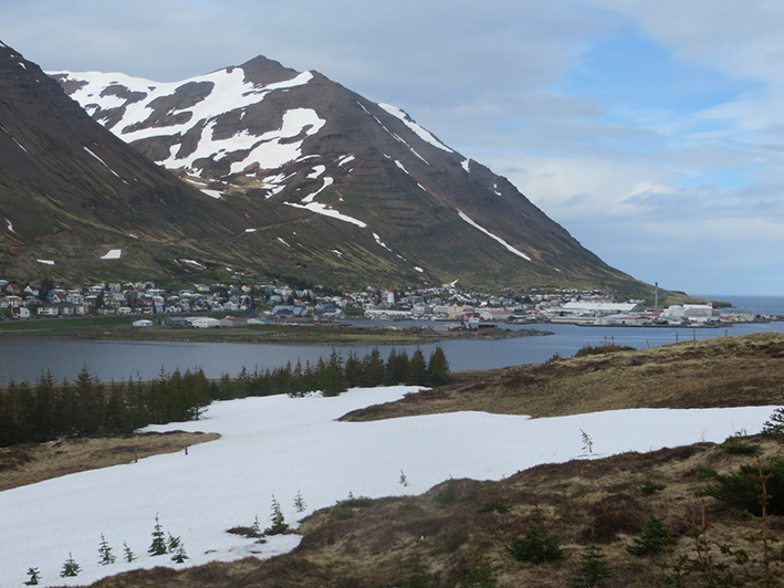
The fishing community of Siglufjörður is today a city where culture, tourism and biotechnology have gained great importance.
Photo: Grétar Þór Eyþórsson.
Ólafsfjörður was not so fortunate. In many ways, the town became a “drive through” on the way between Siglufjörður and Akureyri. Nevertheless, the location of Tröllaskagi Upper-Secondary School, which services both towns, was created in Ólafsfjörður in 2010 (see mtr.is). With almost 500 students,[1]Menntaskólinn á Tröllaskaga. Ársskýrsla 2021. the school has increased economic diversity in the town. Still, Ólafsfjörður is primarily a fishing town, while things have changed more dramatically in Siglufjörður.
Footnotes
- ^ Menntaskólinn á Tröllaskaga. Ársskýrsla 2021.
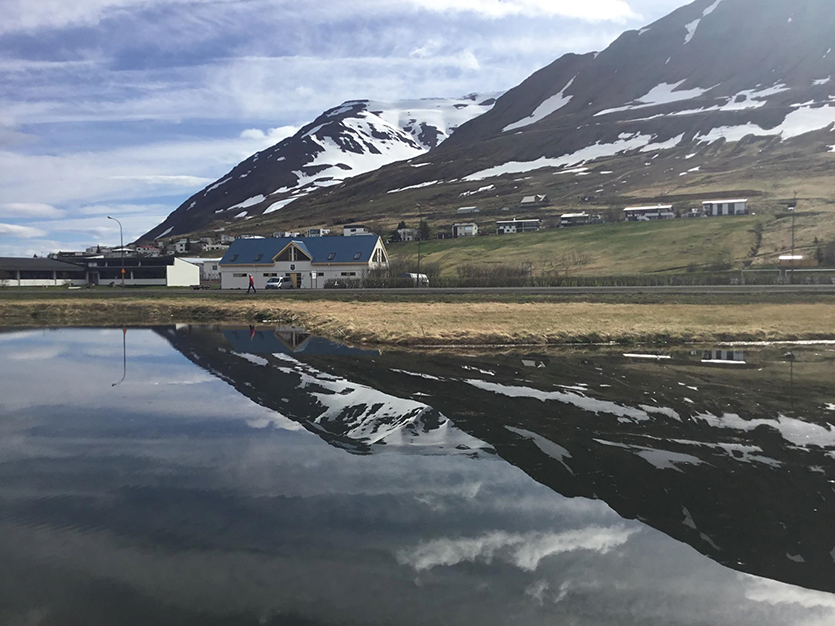
Still primarily a fishing community, education and tourism are of great importance to today's Ólafsfjörður.
Photo: Grétar Þór Eyþórsson.
Data on the municipality’s economic structure, measured by taxable wages and salaries classified by economic activity is shown in Figure 3.10. Here we see very clearly the great transformation of Fjallabyggð as a whole, from a fishing town to a more diverse service- and knowledge-based community with rapidly growing tourism. The changes are clearest between 2008 and 2018, a period which runs from the point just before the opening of the tunnel to the point just before the COVID-19 pandemic. The 2020 data captures the impact of the COVID-19 pandemic.
Figure 3.10: Economic structure in Fjallabyggð 2008-2020. (Taxable wages in millions ISK).
Source: Icelandic Regional Development Institute (byggdastofnun.is) & Statistics Iceland (hagstofa.is).
3.3.1 Fisheries
Siglufjörður, a town of about 1300 people, and Ólafsfjörður, a town of about 1100 people, were both quite traditional fishing communities, prior to amalgamation. Both had experienced job reductions in the fishery sector before amalgamation, mostly due to increased fish processing aboard trawlers, as well as the fishing quota system, which permitted sales and transfers of quota among municipalities and regions (Bjarnason & Stefánsson, 2010; Eythórsson, 2010).
Fisheries remain important in many communities in northeast Iceland, even though the number of jobs in the sector is declining. Allocated quota is much higher in Ólafsfjörður than in Siglufjörður (see Figure 3.11). Fish landings, on the other hand, are much higher in Siglufjörður (see Figure 3.12), as Siglufjörður has a large port for offloading. Still, most of the catch is transported by trucks to fishing plants in other parts of Iceland, often in southwest Iceland.
Figure 3.11: Allocated cod quota in kilos in Siglufjörður and Ólafsfjörður 2013/2014 to 2019 to 2020.
Source: Icelandic Directorate of Fisheries (fiskistofa.is).
Figure 3.12: Catches in species other than pelagics – biggest landing ports in Northeast Iceland (2007-2018).
Source: Icelandic Regional Development Institute (byggdastofnun.is) & Statistics Iceland (hagstofa.is).
The total income from fishing in northeast Iceland shrank by 30% between the years 2008 and 2017, as did jobs in the fishing industry (Einarsdóttir et al. 2019). Still, the fishing industry remains important in the northeast region. Additionally, the average salaries in all sectors in Fjallabyggð were 5,5 million ISK in 2018, while the country average was around 6 million ISK. That leaves Fjallabyggð 10% under the country average in general (www.hagstofa.is).
3.3.2 Tourism
Tourism in Fjallabyggð increased dramatically in the years after the opening of the road tunnel in 2010. As mentioned above, a wealthy individual returned to Siglufjörður with funds gained from the sale of fish quotas, and began to invest, along with others, in hotels, restaurants and biotechnology. This individual is estimated to have invested 5 to 6 billion ISK, primarily in the Siglufjörður economy (the equivalent of 33 to 40 million Euros). Ólafsfjörður was far less affected by this private investment.
A study of the number of foreign tourists in Siglufjörður from 2004 to 2018 demonstrates major growth in the number of tourists over this period, especially from May to September (Guðmundsson, 2019). For example, the number of tourists in July grew from about 4.000 to 23.000 over the period from 2004 to 2018.
Generally, foreign tourism in Iceland expanded dramatically in the twenty-first century, by 655% between 2004 and 2018.[1]www.ferdamalastofa.is/en At the same time, expansion in Fjallabyggð was more than 750% (Guðmundsson, 2019, p. 18). The tunnel, and investments in tourism in Siglufjörður, are the primary factors behind the local expansion.
Footnotes
3.3.3 Biotechnology
The biotechnology company Genis was established by Róbert Guðfinnsson in 2005. The company, operating in Siglufjörður, is a limited liability company and produces therapeutic chitin derivatives (chitin-based products derived from the North Atlantic shrimp exoskeleton). As described on its website, the company is “pioneering the development of therapeutic chitin derivatives ... by providing effective therapeutic solutions across a number of inflammatory diseases ... also developing a number of orthobiologic applications that are based on the regenerative tissue and osteogenic activities and anti-bacterial properties of chitin derivatives.”[1]https://genis.is/ Today, 17 people work at Genis, many of them young, educated scientists. The company’s intention is to expand, a goal which has been postponed by the COVID-19 health crisis.[2]https://www.ruv.is/frett/liftaeknifyrirtaekid-genis-i-storsokn
Benecta is a part of Genis. Benecta’s natural food supplements and medicines are aimed at fighting ageing problems, like stiffness, lethargy and pain. The products are made from chemicals extracted from shrimp exoskeletons. Benecta Osis helps with menstrual cramps and endometriosis.
3.4 Changing Viewpoints in Siglufjörður and Ólafsfjörður
Due to the COVID-19 situation in Iceland since March 2020, we decided to collect data from the people of Siglufjörður and Ólafsfjörður through a combined mail and telephone survey. Until the spring of 2021, the pandemic did not allow any interviewing visits to the two towns. Focus groups meetings have also been impossible. The survey was conducted in February 2021 by the University of Akureyri Research Centre (RHA). A total random sample of 600 was drawn from both towns in order to get data to compare views between the towns. Out of the 600 people selected, a total of 298 participated (49,7%). The survey primarily focused on the situation in the period between 2000–2005 and today.
3.4.1 The regulatory impact: Inputs from the state affecting development
The Icelandic state has done three significant things to encourage development in the communities: a) build the road tunnel between the towns, which opened in 2010; b) facilitate the amalgamation of the municipalities of Ólafsfjörður and Siglufjörður in 2006; and c) create the state-run upper-secondary school in Ólafsfjörður in 2010. The tunnel can be seen as a prerequisite to the other measures, since the amalgamation could not have taken place without it, and the isolation of Siglufjörður couldn’t have been reduced without it. The results from the survey show us the importance of all this in the eyes of the people, with little difference apparent between the towns.
Figure 3.13: “The emergence of the amalgamation/school/tunnel has had positive effects in my town”. Percent who totally agreed or agreed.
The upper-secondary school is seen as a positive input to the communities. The tunnel is also viewed positively, but less so in Ólafsfjörður. The tunnel, which diminished the geographic isolation of Siglufjörður, and was more vital for development there. This we see in Figure 3.14. The amalgamation of the two municipalities is generally seen as a positive input (55%), but the people of Ólafsfjörður are much less satisfied with this step (30%). The survey indicates that the people of Ólafsfjörður feel that specific services in their town have declined in their part of the municipality. How municipal services worsened in Ólafsfjörður but not in Siglufjörður, must be examined further.
Figure 3.14: People in Siglufjörður and Ólafsfjörður believing that selected municipal services have developed positively for the last two decades in percentages.
3.4.2 Changes in economic life
Diversity in economic life during this transformation period is something we asked about in the survey. Responses varied both between the towns and among age groups. As figure 3.16 shows, only 13% in Ólafsfjörður agreed that the economic life was more diverse than before, while this proportion was 68% among the respondents living in Siglufjörður. Younger people generally see more diversity. In the youngest group (35 years and younger), almost two thirds or 64% believe that economic life is more diverse than before, while we see a linear decline down to 34% for the oldest group.
Figure 3.15: The economic life in my town is much more diverse than it was before, by town and age. Percent who totally agreed or agreed.
An open-ended question on economic development was also asked in the survey. This was an attempt to probe issues which were not pre-defined by the research team. After doing content analysis on the open-ended answers to identify the main issues mentioned, we got the following results, here presented by respondent´s residence and by age.
Figure 3.16: „What words come first to your mind when you think about the economic development in your town for the last 10–15 years or so”? By town. Open-ended answers classified with content analysis.
Looking at the results by residence in Siglufjörður or Ólafsfjörður, we see a clear pattern. In Siglufjörður, people perceive significantly more upswing in the economic life and diversity as well. Not surprisingly, tourism is frequently mentioned. By contrast, we see a far higher percentage in Ólafsfjörður mentioning stagnation or regression as a first response to describe development for the last 10 to 15 years or so. Different development patterns between the two towns are recognised by the people in this survey.
Analysing the data by age we see even more interesting trends. The youngest group participating in the survey (35 years and younger) differs significantly from the older ones in their views of economic development over the last 10 to 15 years. Firstly, they mention the gymnasium school more frequently than the others; secondly, they mention diversity much more frequently than the others; thirdly, they mention innovation and new firms more frequently than the others; and finally, they do not see stagnation or regression nearly as much as the older respondents do. In other words, the younger people tend to see things related to the transformation of economic life more positively than older people (Figure 3.18). All these differences are evident in Figure 3.18, where we see open-ended answers after categorization by content analysis.
Figure 3.17: „What words come first to your mind when you think about the economic development in your town for the last 10–15 Years or so”? By age. Open-ended answers classified with content analysis.
One could say that the attitudes of the younger people indicate that the communities of Siglufjörður and Ólafsfjörður are resilient in the way that the changes are viewed, where the disappearance of jobs in the primary sector is not seen as stagnation or even regression. Age seems to be very important in the community´s ability to adapt to the changes. That is very important since the future is in the hands of the young. We have to bear in mind that the community is ageing, as seen in Figure 4, with the age-group 0–19 declining, but 60+ is on the rise. But then again, the 20–39 group is also growing somewhat, and it is an important age group, since they are the ones raising families.
“Gender” is not associated with any significant differences in these perceptions. Also, those with university education mentioned tourism, innovation, and diversity more frequently than the less educated, while the less educated mentioned stagnation and regression.
3.5 Comparing the two towns
The socio-economic changes in the municipality of Fjallabyggð, containing the two towns Siglufjörður and Ólafsfjörður, have primarily been created by the national government. A state-built road tunnel connecting the towns, financial support for the amalgamation of the municipalities and the foundation of the state run upper-secondary school in Ólafsfjörður were all significant inputs from the state with the tunnel as the prerequisite for all these. These changes stimulated investment in tourism and biotechnology, led by an individual who also has invested significantly in biotechnology companies such as Benecta and Genis. Siglufjörður and even Ólafsfjörður, to some extent, have been transformed from traditional fishing towns to communities with much more mixed economic lives. The value chains have changed in the municipality of Fjallabyggð as a whole, but particularly in Siglufjörður, where both tourism and biotechnology have become a significant part of economic life. The value chains have changed less in Ólafsfjörður, but the upper secondary school located there brought new jobs into the community. Today 29 people are employed at the school and more young people are being educated. That of course is a significant change of the value chain in the town.
Before 2000, the decline of fishing and fish processing led to depopulation and ageing communities. The fishery decline, and associated demographic changes, were the main reasons for state involvement in financing the road tunnel. In a parliamentary resolution on a policy for rural and regional development from 1999, it was argued that the premises for positive development and growth were safe and effective road communications and stronger municipalities (Alþingi, 1999). Shortly after, a decision on the road tunnel project in Fjallabyggð was made. The input of a private investor, Róbert Guðfinnsson, also plays an important role. All those financial decisions and actions weigh heavily in building resilience in those two communities, especially in Siglufjörður. It also raises the question of what would have happened without these external inputs. The growth in the new sectors meant that both skilled and unskilled workers had to be recruited externally, and a local workforce willing to make adjustments was required. This seems to have succeeded. Would the people in those two towns, facing depopulation and an ageing community, have had the strength to adapt and go further on their own?
How have the people in the two towns adapted to what has happened after 2005? We have shown that Siglufjörður and Ólafsfjörður have followed somewhat different trajectories. People in Ólafsfjörður are not as happy with the economic changes. In the survey we see more positive viewpoints among the people in Siglufjörður. Further, people in both towns agreeing with the statement that conflicts and disputes between people in the two towns do exist. That is of course something that might threaten a positive development towards a better community in Fjallabyggð. We also see – not surprisingly – more optimistic views among the younger people in the survey. That shows us how necessary it is for every community to have more equal distribution of age groups.
References
Alþingi (1999). Þingsályktun um stefnu í byggðamálum fyrir árin 1999–2001. 123. Löggjafarþing 1998–99. Þskj. 957 – 230. mál.
Bjarnason, T. & Huijbens, E. H. (2015). Stefna íslenskra stjórnvalda og vöxtur ferðaþjónustu á jaðarsvæðum: Áhrif Héðinsfjarðarganga í Fjallabyggð. Icelandic Review of Politics and Administration 10(2), 565–586.
Bjarnason, T. & Stefánsson, K. (2010). Samgöngubætur og byggðaþróun á norðanverðum Tröllaskaga. (Road improvements and regional development in outer Tröllaskagi peninsula). In Th. Bjarnason & K. Stefánsson (2010), Fjallabyggð fyrir Héðinsfjarðargöng. Samgöngur, samfélag og byggðaþróun. (p. 4–15) Akureyri: Háskólinn á Akureyri.
Byggðastofnun (2020). Norðurland eystra. Stöðugreining 2019. Sauðárkrókur, Byggðastofnun.
Clifton, D. (2010). Progressing a Sustainable-world: A Socio-ecological Resilience Perspective. Journal of Sustainable Development, 3(4), 74–96.
Dredge, D. (2019). Governance, tourism and resilience: A long way to go? In J. Saarinen & M. A. Gill (Eds.), Resilient Destinations and Tourism: Governance Strategies in the Transition towards Sustainability in Tourism, p. 48–66. Routledge.
Einarsdóttir, M., Jóhannesson, A. & Þórsteinsdóttir, G. R. (2019). Menntunarþörf í Eyjafirdi og í Þingeyjarsýslum. Könnun meðal fyrirtækja og stofnana á starfssvæði Eyþings. Akureyri, Iceland: RHA.
Eythórsson, G. T. (2010). Sveitarfélagið Fjallabyggð og Héðinsfjarðargöng. (The municipality of Fjallabyggd and the Héðinsfjörður tunnel). In Th. Bjarnason & K. Stefánsson (Eds.), Fjallabyggð fyrir Héðinsfjarðargöng. Samgöngur, samfélag og byggðaþróun, (p. 116-124). Háskólinn á Akureyri.
Eythórsson, G. T. & Karlsson, V. (2011). Vestnorden Foresight 2030. The foresight of the people in Borgarbyggð and Fjallabyggð, Iceland. Skýrsla SSV 1.
Giacometti, A. & Teräs, J. (Eds.). (2019). Regional Economic and Social Resilience: An Explanatory In-depth Study in the Nordic Countries. Nordregio Report 2019:2.
Gløersen, E. (Ed.) (2012). Vestnorden Foresight 2030 – Sluttrapport. Spatial Foresight.
Heiðarsson, J., Ólafsson, K., Arnarsson, S. & Bjarnason, T. (2010). Umferð á norðanverðum Tröllaskaga: Erindi og áfangastaðir vegfarenda. (The traffic pattern in outer Tröllaskagi peninsula). In Th. Bjarnason & K. Stefánsson (Eds.), Fjallabyggð fyrir Héðinsfjarðargöng. Samgöngur, samfélag og byggðaþróun, (p. 16–29). Háskólinn á Akureyri.
Holling, C. S. (1996). Engineering Resilience versus Ecological Resilience. In P. C. Schulze (Ed.), Engineering Within Ecological Constraints (p. 31–44). National Academy Press.
Jóhannesson, H. (2002). Byggð og atvinnulíf í Eyjafirði Samantekt vegna byggðaáætlunar Eyjafjarðar. Byggðarannsóknastofnun.
Jóhannesson, H., Eythórsson, G. T. & Ólafsson, K. (2001). Jarðgöng og vegagerð á norðanverðum Tröllaskaga. Mat á samfélagsáhrifum. RHA.
Olgeirsson, F. G. (1991). Hundrað ár í Horninu. Saga Ólafsfjarðar eftir 1945. 3. Bindi. Ólafsfjarðarbær.
Guðmundsson, R. (2019). Ferðamenn í Fjallabyggð 2004–2018. Hafnarfirði, Iceland: Rannsóknir og ráðgjöf ferðaþjónustunnar. https://www.fjallabyggd.is/static/research/files/rannsoknir-og-radgjof-2019pdf
Menntaskólinn á Tröllaskaga. Ársskýrsla 2021. (Annual Report). https://www.mtr.is/static/files/arsskyrslur/arsskyrsla-mtr-2021.pdf
Saarinen, J. & Gill, M.A. (2019). Introduction: Placing resilience in the sustainability frame. In J. Saarinen & M. A. Gill (Eds.), Resilient Destinations and Tourism: Governance Strategies in the Transition towards Sustainability in Tourism (p. 3–12). Routledge.
Siglfirðingablaðið. (1998). Ágrip úr ræðu formannsins Jóns Sæmundar Sigurjónssonar á afmæli Siglufjarðar sl. Sumar. Siglfirðingablaðið, 11(2), p. 12–13. https://timarit.is/page/5005707#page/n11/mode/2up
Þórðardóttir, S. E. (2018). Þjónustukönnun. Norðurland eystra. Sauðárkrókur. Byggðastofnun.
Walker, B., & Salt, D. (2006). Resilience Thinking: Sustaining Ecosystems and People in a Changing World. Island Press.
Chapter 4: Divergent development trajectories: Tvøroyri and Vágur in the Faroes
Ragnheiður Bogadóttir, Firouz Gaini & Gestur Hovgaard
4.1 Introduction
The two municipalities of Tvøroyri and Vágur on the island of Suðuroy represent the Faroese cases in this study on sustainable value chains and community resilience. The focus in the text is on changes in the most important value chains for these two communities during the period between 2000 and 2020. Tvøroyri and Vágur are interesting in a comparative perspective because of their proximity and similar circumstances, and yet divergent developmental trajectories. This has become particularly evident in the past decade during which the municipality of Vágur has consciously sought to forge a development path towards a more diversified and experience-based economy, while in Tvøroyri large investments have been made in the pelagic fisheries industry.
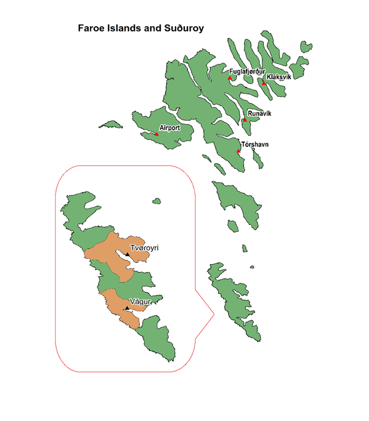
| Area | Population (Jan 2021) | |
| The Faroes | 1394 km2 (100%) | 52903 (100%) |
| Suðuroy | 165 km2 (11.8%) | 4660 (8.8 %) |
| Tvøroyri | 43 km2 (3%) | 1744 (3.3%) |
| Vágur | 21 km2 (1.5%) | 1392 (2.6%) |
Map 4.1: Map of the Faroes and the case areas in Suðuroy.
Source: Statistics Faroe Islands (www.hagstova.fo). Map produced by Bogadóttir
Data source: Faroe Environment Agency (www.us.fo).
The chapter is divided into six sections, beginning with a short historical and geographical overview of the case areas, while the following sections focus on the period between 2000 and 2020. Section 4.3 is about demographic change, and section 4.4 examines the municipal structure. Section 4.5 focuses on the changes in local value chains during the same period, and section 4.6 closes the chapter with some tentative conclusions on community resilience in the case areas. The historical introduction is based on available literature, while the following sections are based mainly on statistical information from Statistics Faroe Islands, field reports, and field observations from our own visits to Suðuroy.
4.2 A socio-economic overview
The two towns of Tvøroyri and Vágur are the largest settlements on Suðuroy. The settlement of Vágur can be dated back to at least the 14th century, while Tvøroyri grew around the Royal Monopoly department, which was established at the site in 1836. Tvøroyri eventually absorbed the older settlements and villages in its vicinity, Froðba, Trongisvágur, Ørðavíkarlíð and Ørðavík, which today constitute the municipality of Tvøroyri. Similarly, Vágur absorbed the settlement of Nes, today comprising the municipality of Vágur. Historically both settlements had a central role in the 19th century transformation of Faroese society, a change which particularly took place from the last quarter of the 19th century (Apostle et al., 2002). The crucial date for this transformation is often set at 1856, when the Royal Trade Monopoly was abolished, and free trade introduced.
Subsistence fisheries, útróður, were organized in the communities in accordance with the traditional land tenure system, and mostly regulated through traditional rights and access to boats. This element of the traditional customary law system was finally abolished by the Danish parliament in 1865, as it was seen as a hindrance to the liberalization of the Faroese economy (Mortensen, 1993). In a Faroese context, the period hereafter has been described as a process of going “from peasant to fisher” (Joensen, 1987), indicating the dramatic shift in traditional livelihoods and social organization of the Faroes, when a large section of the Faroese male population went away on long-distance fisheries. The narrative of this transition has often been one of free enterprise and progress, but for the people involved, the changes were not always voluntary, appropriate or welcome. Recent historical research suggests that the changes were mostly promoted by Danish officials stationed in the Faroes, and partly by members of the Faroese elite (Isholm, 2020). The changes involved the strategic formation of a market society, as well as a Faroese working class (Hovgaard, 2019).
When the Royal Trade Monopoly was abolished in 1856, the infrastructure that was already in place in Tvøroyri continued to support commercial activities, as several merchants and shopkeepers started businesses there, and in Vágur. In addition, good fishing grounds nearby and excellent port conditions in Tvøroyri and Vágur facilitated a growing fisheries economy. In this initial period of classical liberalism (Hovgaard, 2001), economic and social life in the Faroes was organized around powerful merchants and ship owners, who not only traded fish on foreign markets; locally, these entrepreneurs replaced the traditional large farmers as the source for income, purchase, and credit for common people. In this period, Vágur and Tvøroyri became the centres of the new economy, producing salted/dried fish for export on the international markets. As local fisheries did not provide enough raw material, Faroese merchants bought fish from foreign ships operating around the islands, and they also set up stores in the smaller villages, where local fishers by útróður could sell their catches and purchase goods. Towards the end of the 19th century, the Faroese embarked upon long-distance fisheries themselves, and during the following decades total catches and the number of long-distance fishing vessels grew dramatically.
For the settlements of Tvøroyri and Vágur, the initial transformation meant a rapid growth in population after 1870, as these areas attracted both people and resources. Men were employed as fishermen and women as seasonal fish processing workers, or shop work, as well as servants for the local elite. In Tvøroyri the population increased more than threefold from 1880 (468) to 1916 (1,522), and in Vágur the population almost doubled from 335 to 645 in the same period. After the initial expansion, population continued to increase steadily, but from the 1950s population stagnated and declined. After the world economic crisis of the 1930s, which also indicated the end of the classical liberal period, the dominant role of Suðuroy as a centre of the Faroese economy shifted more towards the northern regions of the Faroes.
After a few prosperous years in the first post-war period, a decade of crisis followed, partly because of failed investments in a new capital apparatus of outdated fishing vessels. Prosperous years restarted around 1960 with a long period of growth up to 1992, when the economy and society basically collapsed. In Suðuroy, this period saw an increase in large modern fishing vessels and large fish processing plants in both Tvøroyri and Vágur. As in other places in the Faroes, the 1992 collapse entailed a dramatic decline in population, which then became relatively stable. These trends in population development can be seen in Figure 4.1 and 4.2 below.
Figure 4.1: Population in Tvøroyri and Vágur between 1801 and 1977.
Source: Statistics Faroe Islands (www.hagstova.fo).
Figure 4.2: Population in Tvøroyri Municipality and Vágur Municipality between 1985 and 2021.
Source: Statistics Faroe Islands (www.hagstova.fo).
The long-distance fisheries that began at the end of the 19th century, marked a shift in Faroese access to and appropriation of marine resources. During the twentieth century, a number of fisheries management regimes have been in place (Danielsen & Agnarsson, 2018; Ellefsen & Bromley, 2021). Until the 1970s, the Faroese long-distance fishing fleet operated in international waters off Iceland, Greenland, and Newfoundland, as well as the North Sea and the Barents Sea. With the nationalisation of the seas during the 1970s, the fleet had to reorganize and mainly operate within the Faroese 200 nautical mile Exclusive Economic Zone (EEZ).
These changes in the international governance of the sea were followed by a large expansion of fish processing plants on land. These years of Faroese Fordist development (Hovgaard, 2001) were strategically centred around national (Faroese/Danish) structures of development, a process that was greatly expanded with the changes in international regulation of the oceans in the 1970s. Substantial public involvement in the fishing industry meant that many trawlers and processing plants were built. By the end of the 1980s, most larger villages in the Faroes had fish processing plants. At one point, 21 plants were basically producing the same kind of cod-fish products (cod, saithe, haddock, and others). In brief, the last three decades of the 20th century are the story of a major economic expansion and then a collapse of the Faroese economy in 1992 (Apostle et al., 2002).
In Suðuroy, and especially in Tvøroyri and Vágur, the years up to the 1992 crisis were also a period of economic prosperity. An increased number of new Faroese and foreign built modern vessels, as well as new industrial processing plants were situated in both towns, and other places on Suðuroy. In addition, large national and municipal investments were made in roads and harbours. This development was also a period accompanied by population increases.
In Tvøroyri the municipality became the main driver for the construction of the then highly modern fish plant and several connected fishing vessels. The investors were mainly a combination of the municipality, the worker unions and local businesspeople that replaced a system of single entrepreneur’s characteristic of the period of classical liberalism. In Vágur the strategy was different, since a local sailor and businessman became the main investor and the owner of the then highly modern fishing plant (today a salmon processing plant), and nearly all the fishing vessels that were based in the town in the 1970s and the 1980s (Apostle et al., 2002).
In 1992, the strategy of Fordist modernisation led to overexploitation of the sea, and public overspending in investment, subsidies, and loans and eventually led to the collapse of the Faroese economy and society (Apostle et al., 2002; Hovgaard, 2001). As in the Faroes in general, the companies in Tvøroyri and Vágur went bankrupt. In a short period of time, the Faroes experienced a 25% decrease in GDP and about 10% of the population emigrated in the early 1990s, primarily to Denmark and other Nordic countries.
In the subsequent restructuration of the Faroese economy the fishing plant in Tvøroyri was integrated into a new national fishing company, while the plant in Vágur stayed closed for many years, so the crisis hit harder in Vágur than in Tvøroyri (Apostle et al., 2002). Although the Faroese economy has recovered, the aftermath of the 1992 crisis is still apparent, in particular the socio-economic impact of the crisis is still evident on a peripheral island like Suðuroy.
During the past decade the Faroese economy has had high growth rates, to a large extent because of the success of the salmon farming industry and the boom in the pelagic industry. Already back in the 1980s, it became clear that salmon farming could be a new alternative to the demersal fisheries as a prime mover in the economy. The fluctuations in the Faroese salmon industry have been volatile, but growth rates have been high for more than a decade. Today, the salmon industry is approaching the fisheries sector in export value. And, while the demersal fisheries (e.g., cod, saithe) have stagnated and declined, the last two decades have witnessed the expansion of a large pelagic industry (mackerel, herring, blue whiting).
The reasons for the changes in the fisheries economy and value chains are closely related to changes in fisheries management and governance regimes. After the economic crisis in the early 1990s, a TAC (Total Allowable Catch) system was introduced by the Danish authorities in 1994. This system only remained in place for two years before it was replaced with a fishing day system. The new fishing day system was an effort quota management system, in contrast to the previous catch quota regime, and was designed to reduce the negative aspects of TAC systems, such as the discard of bycatch. In retrospect, however, the system failed to effectively regulate effort, and Danielsen and Agnarsson (2018) state that it has resulted in overfishing, fleet overcapacity and low profitability in the demersal fleet. As demersal fisheries have declined in importance, pelagic fisheries and salmon farming have grown. Pelagic fisheries are not governed through the Faroese fishing day system, but jointly with other coastal states through TACs and ITQs (Individual Transferable Quotas). The general decline in the demersal fisheries and the new pelagic and aquacultural value chains are now apparent in Tvøroyri, and in Vágur. In this new situation, Tvøroyri has become one of the main ports in the Faroes for the landing and processing (freezing) of pelagic fish. The salmon farming industry, more precisely the Faroese based, and globally dominant company Bakkafrost has announced plans for large investments in production on Suðuroy, especially in the municipality of Vágur. On their website, Bakkafrost reports that the company is a fully vertically integrated producer of Atlantic salmon and is now the largest employer on the Faroes.[1]See www.bakkafrost.com
The past two decades have also seen the emergence of a conscious and successful political strategy to increase tourism in the Faroes and make it a “third leg” of the economy, along with fisheries and aquaculture. As tourism is growing, most regions in the Faroes are hoping to benefit, but the infrastructure and institutions are not yet in place; the sudden increase in visitors has resulted in conflict and disputes in many areas. On a political level, tourism has resulted in strife over access to land, the freedom to roam, and land use in general. On a local level, several conflicts have emerged, especially over destinations that are very popular with tourists, which are often places with magnificent nature attractions, but few inhabitants (Svartá et al., 2020). The tourist industry has also emerged in Suðuroy, and the municipality of Vágur can be seen as a special case in the Faroese context in the sense that the planning of a tourism economy infrastructure was initiated in expectation of increased tourism rather than because of it. In 2013 the municipality embarked upon a strategy oriented towards an experience economy and has managed to build infrastructure to support tourism and secure local benefits from the increased tourism flows.
Footnotes
- ^ See www.bakkafrost.com
4.3 Demographic change and settlement structure
With a total population of 4,660 (in January 2021), Suðuroy comprises 7 municipalities. 37% of the Suðuroy population lives in Tvøroyri municipality, and 30% live in Vágur municipality. Together these two largest municipalities thus make up almost exactly two thirds of the total Suðuroy population. There are 14 settlements in total on Suðuroy. Vágur consists of the settlements of Vágur and Nes, while Tvøroyri consists of the settlements of Froðba, Tvøroyri, Trongisvágur, Ørðavíkarlíð and Ørðavík. In this work, the terms Tvøroyri and Vágur are used to include these settlements.
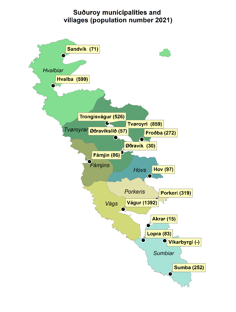
| Municipalities | Population |
| Hvalba Municipality | 670 |
| Tvøroyri Municipality | 1,744 |
| Fámjin Municipality | 86 |
| Hov Municipality | 97 |
| Porkeri Municipality | 319 |
| Vágur Municipality | 1,392 |
| Sumba Municipality | 350 |
Villages/ Settlements | Population |
| Hvalba | 599 |
| Sandvík | 71 |
| Froðba | 272 |
| Trongisvágur | 526 |
| Tvøroyri | 859 |
| Ørðavík | 30 |
| Ørðavíkslíð | 57 |
| Fámjin | 86 |
| Hov | 97 |
| Porkeri | 319 |
| Vágur | 1,392 |
| Lopra | 83 |
| Sumba | 252 |
| Víkarbyrgi | 0 |
| Akrar | 15 |
Map 4.2: Table and map of Suðuroy showing municipalities, villages and population numbers (January 2021).
Source: Statistics Faroe Islands (hagstova.fo); Map produced by Ragnheiður Bogadóttir 2022. Data source: Faroe Environment Agency (us.fo).
Demographic change in the period between 2000 and 2020 has not been dramatic. In 2000, the total population in Tvøroyri was 1,783, and 1,711 in 2020 (1,744 in 2021). In Vágur the numbers are 1,403 in the year 2000 and 1,352 in 2020 (1,392 in 2021). With some variation between years and slight trends, the population has been slightly declining, but relatively stagnant. In both communities there is an overrepresentation of men compared to women, which is also a common characteristic of peripheral areas (Figures 4.3, 4.4 and 4.5). For the smaller municipalities in Suðuroy the decline in population has been relatively larger than in Tvøroyri and Vágur. For smaller municipalities like Hov and Fámjin, the decline is around 15–20%. The smaller the settlement, the larger the decline is. It should also be noted that Hvalba municipality consists of the villages Hvalba and Sandvík, and here the larger settlement Hvalba has witnessed a decline of around 7% while the decline in Sandvík is close to 40%.
While the population in Tvøroyri and Vágur is relatively stagnant, the age pyramids (Figures 4.5a, 4.5.b, 4.6a & 4.6b) in both communities show changes between 2000 and 2020, with a clear trend towards an ageing population. The age groups between 20 and 40 are especially small. The ageing trend is already clear for women in 2000, and by 2020 it is also significant for men, particularly in Vágur.
Figure 4.3: Population in Tvøroyri and Vágur by gender.
Source: Statistics Faroe Islands (hagstova.fo).
Figure 4.4: Population in Tvøroyri and Vágur between 2000–2021.
Source: Statistics Faroe Islands (hagstova.fo).
Figure 4.5a: Population in Tvøroyri by gender and age per January 2000.
Source: Statistics Faroe Islands (hagstova.fo).
Figure 4.5b: Population in Tvøroyri by gender and age per January 2020.
Source: Statistics Faroe Islands (hagstova.fo).
Figure 4.6a: Population in Vágur by gender and age per January 2000.
Source: Statistics Faroe Islands (hagstova.fo).
Figure 4.6b: Population in Vágur by gender and age per January 2020.
Source: Statistics Faroe Islands (hagstova.fo).
Out migration in peripheral and rural areas is a widely recognised phenomenon when it comes to young women. This pattern is clearly visible in both Tvøroyri and Vágur, and Suðuroy in general. Some of the commonly given explanations for this trend are the lack of (skilled) labour opportunities, the lack of higher educational institutions, and of cultural and leisure services in Suðuroy (Gaini, 2015; Holm, 2009). During the period between 2000 and 2020, employment in fisheries has declined while public sector employment has increased. This is partly because of the deliberate placement of public sector offices in Suðuroy, many of which are located in Tvøroyri. Public sector institutions include the hospital in Tvøroyri, the national public transport office in Tvøroyri, an upper-secondary school in Hovi (midway between Tvøroyri and Vágur), a nursing school (with Hovi campus), a sports college school in Vágur, and old age homes, along with several kindergartens. Their importance can hardly be overestimated, as these institutions provide stable, skilled work opportunities, as well as basic services to the local communities.
In both places, net migration is characterised by relatively strong variations, and birth surplus fluctuates around zero, as can be seen in Figures 4.7 and 4.8.
Figure 4.7: Net birth surplus, net migration and net domestic migration in Tvøroyri municipality.
Source: Statistics Faroe Islands (hagstova.fo).
Figure 4.8: Net birth surplus, net migration and net domestic migration in Vágur municipality.
Source: Statistics Faroe Islands (hagstova.fo).
Overall, the birth rate in Suðuroy from 1985 onwards has been negative. The low birth rate can be explained by the relatively small proportion of residents in their childbearing years, as shown in the population pyramids (Figures 4.5a, 4.5.b, 4.6a & 4.6b). In terms of recent population trends, Suðuroy, especially Tvøroyri and Vágur, have gained from the general increase in the Faroese population (Hagstova Føroya, 2021). Today, approximately 4,5% of the Faroese population have non-Danish (Faroese) origins, a proportion which was 1,6% in 2002 and 2,8% in 2018.[1]See https://hagstova.fo/fo/folk/folkatal/rikisborgaraskapur The largest groups are from Thailand, the Philippines, and eastern Europe. A considerable number of these international migrants have found their way to Suðuroy. While the recent growth in Vágur is domestic migration, the growth in Tvøroyri is international migration. The probable explanation for this difference is the fact that traditional fish production, and the new pelagic industry in Tvøroyri, depend on foreign labour.
Footnotes
4.4 Municipal structure 2000–2020
The municipal system is a result of early modernization and dates to 1873, when the Faroes was divided into eight municipalities and the whole island of Suðuroy became one municipality. Since then, the municipalities have been key local units for local self-determination and local service provision. Early on, especially during the first half of twentieth century, the larger municipal units broke up so that nearly every village (bygd) became its own municipality. In 1967, the number of municipalities in the Faroes peaked at 51. Since then, the number of municipalities has declined because of amalgamations. In 2005 the number went from 48 to 34 and today there are 29 municipalities. These changes have taken place without any overall strategy or plan for division of labour or tasks between the national and local levels. The amalgamations that have taken place in recent years are founded in the reality that many small municipalities find it impossible to undertake the tasks they now face in the areas of welfare and services, especially in the elder care sector.
In Suðuroy, the division of the municipal unit began in 1878, when Hvalbiar municipality separated from the larger Suðuroyar municipality, and shortly thereafter – in 1879 – Froðbiar municipality (which later became Tvøroyrar municipality) followed. Vágur became its own municipality in 1906/7, and in 1908 the remaining Suðuroy area was divided into Porkeris, Sumbiar, and Fámjins municipalities. In 1920, Hov became an independent municipality as well, separated from Porkeri municipality. This municipal structure is still in place today. Although proposed amalgamations of the municipalities have been discussed and attempted, local differences and resistance have hindered the process. The smaller municipalities have been especially opposed to amalgamation because of their concern that local authority and self-determination, in relation to local community development, would be undermined. In Tvøroyri, the municipality with the largest population in Suðuroy, the issue of amalgamation has been posed in polls with a majority in favour.
In 2012, an advisory referendum was organized on the issue of municipal amalgamations in the Faroes. The proposal was to merge the existing municipalities into seven larger municipalities. For Suðuroy it would mean that the whole island would be merged into one municipality. In Suðuroy, two thirds of the votes were against the proposed amalgamation, a result that also reflects the political and cultural divides in Suðuroy.
Thus, although amalgamations have been on the political agenda in Suðuroy for decades, the existing structure remains in place. At the national level, there is currently no plan to force amalgamations, even if voluntary amalgamations are encouraged at the national level.
4.5 Changing value chains
As argued in the Introduction, the communities of Tvøroyri and Vágur have, both on the real and rhetorical levels, chosen to pursue divergent development strategies during the last two decades. This section describes the economic infrastructure and development that has come out of these strategies in recent years. Most visible in Tvøroyri are the very large investments that have been made in the pelagic fisheries industry, making it, as already stated, one of the main landing ports for pelagic fish in the Faroes. In Vágur, a conscious strategy to transform the economy from a fisheries economy to a service and experience economy, initiated by the municipality, is most distinctive. But, as will be explained, the value chains which characterise the local economies are much more complex than the dominant development strategies suggest.
The changes in sector employment in Suðuroy visible in Figures 4.9 to 4.11 are a clear indication of the changes in local value chains which have taken place over the last two decades. The clearest trend is the decrease in number of people employed in demersal fisheries and the increase in number of people employed in the public sector.
Figure 4.9: Employees in Suðuroy region by sector per January 2000.
Source: Statistics Faroe Islands (hagstova.fo).
Figure 4.10: Employees in Suðuroy region by sector per January 2020.
Source: Statistics Faroe Islands (hagstova.fo).
Figure 4.11: Employment by industrial sector for Suðuroy region 2000–2022.
Source: Statistics Faroe Islands (hagstova.fo).
Around the year 2000 there was still a significant and diverse fisheries infrastructure in Tvøroyri and Vágur; it included deep-sea trawlers, pair trawlers, longliners and seiners. On land, there were factories doing salting, drying and freezing. In a matter of only a few years, the fisheries infrastructure looks very different on Suðuroy. While some demeral fisheries infrastructure remains in the village of Hvalba, it is heavily reduced in Tvøroyri and Vágur. The fact that demersal fisheries have all but disappeared within a single decade has to some degree left these communities in a void between a familiar past as fishing communities and a new reality of unexplored economic pathways.
4.5.1 The new local economies
Tvøroyri is the main port of Suðuroy, where the ferry between Suðuroy and the capital of Tórshavn docks, and through which most passenger and cargo pass. The heliport serving Suðuroy, as part of the national passenger helicopter service, is in the municipality of Tvøroyri. Tvøroyri also benefits from several public institutions, which have their regional offices located there. Examples include Landsverk (road services), Strandfaraskip Landsins (the public ferry company), TAKS (the national tax office), Almannastovan (the national social security office), as well as a hospital, and the police.
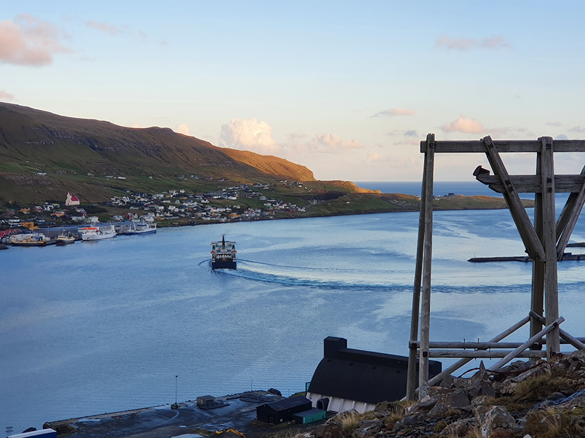
The 2 to 3 times daily ferry route from Tvøroyri to the mainland is crucial for social and economic life on Suðuroy. Here the ferry Smyril leaving port of Tvøroyri.
Photo: Rasmus Steintórsson Biskopstø.
Tvøroyri is comprised of several smaller settlements that have grown together along the shore of the Trongisvágsfjørður fjord. The many older and charming mansion-style houses reflect the twentieth century success of the place. The decision to construct a modern pelagic processing plant right on the waterside, in front of some of the town’s historic buildings, created some controversy. Nevertheless, production at the “Varðin Pelagic” plant started in 2012. With 76% of the shares, the parent company is Varðin, which is a large Faroese owned, vertically integrated company in both pelagic and demersal fisheries. Varðin owns several vessels and factories around the Faroes and has a turnover of more than DKK one billion, as well as nearly 400 employees.[1]See www.vardin.fo. The plant in Tvøroyri has a capacity of approximately 1,000 tons of pelagic fish per day, and annual production is reported to be around 80,000 tons. The production is mainly mackerel, herring, blue whiting, and capelin, and employment is around 50 full-time and 100 seasonal jobs. The fishing season for these stocks is from August to February. Tvøroyri also has a demersal fish factory, Delta Seafood, which processes demersal fish species (cod, saithe, ling, tusk, blue ling). Annual production is around 4,000 to 5,000 tons, and the factory provides stable employment for some 50 people year-round.
Tvøroyri has a historical museum, an art gallery, a hotel, and a few bars, cafés, and restaurants. A very large salt silo, constructed in 1938 and used in the booming saltfish industry, has recently been restored and converted into a cultural house. Recently, a post-elementary boarding school aiming to attract students for post-elementary students from Suðuroy and beyond was established. The local tourism office, Visit Suðuroy, has one person employed in Tvøroyri who works closely with the municipality to organize and develop the tourism industry.
In the 1970s, Vágur was one of the largest fishing communities in the Faroes and was home to the most modern fish factory in the country. By the turn of the century, however, Vágur faced a lot of challenges: out-migration, especially of younger people, lack of jobs, low wages, negative images in national media, and the like. In 2010, the fishing industry was still very important in Vágur, employing some 200 workers at the factories on the waterfront. These operations included a fish auction, a fish drying plant, a filleting plant, fish salting companies, and a cold storage plant. Between 50 and 80 people from Vágur – mostly men – were also working on both smaller and larger fishing vessels. In all, the fishing industry accounted for between 250 and 300 jobs in Vágur. By 2016, there were less than 20 jobs left in this sector. Until 2017, fish farming in Vágur was run by a local company, Faroe Farming. Today Bakkafrost is the only salmon farming company in operation on Suðuroy, and it runs a processing plant in Vágur that employs around 50 people, mostly on a seasonal basis.
Footnotes
- ^ See www.vardin.fo.
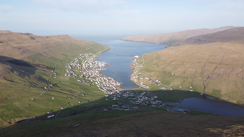
The fishing community of Vágur is transformed to base its economy on aquaculture, tourism, and education.
Photo: Dennis Holm.
In 2013, the population in Vágur was at an historic low, and the municipality put forward a new strategy for development. The town initiated several projects to move the community in an alternative direction. These new projects included the establishment of a sports college, the construction of a new multi-purpose indoor sports hall, and the first 50 metre indoor swimming facility in the Faroes, named Páls høll. Páls høll was a community project built partly with voluntary local labour and financed through a combination of crowdfunding as well as municipal and national government support. Another focus has been in education, where investments have been made in improving elementary schools with more opportunities for creative activities, including knowledge about the local environment and agriculture/fishing, as well as arts and music. A distance learning centre for higher education has also been established, with responsibility for providing a working space and the technical facilities for distance education. The municipality also consciously sought to (re)build a sense of community by organizing public breakfasts, joint cleaning days and local bonfires. Despite its location on the periphery, Vágur has population increases comparable to the country as a whole.
Fisheries
The fish value chains in Suðuroy can be said to include small-scale fisheries, industrial fisheries, and aquaculture (salmon farming and seaweed farming). Although there is variation, on a general level, the changes in the fish value chains have gone from being labour-intensive to becoming capital- and resource-intensive. The volume of raw fish landed and processed in Tvøroyri has increased and is today estimated at 85,000 tons annually (46 tons per capita in Tvøroyri municipality). Some 80,000 tons are pelagic fish products, and 4 to 5,000 tons are demersal fish products. In most cases, the value creation is significantly higher for demersal fish products per kilo.
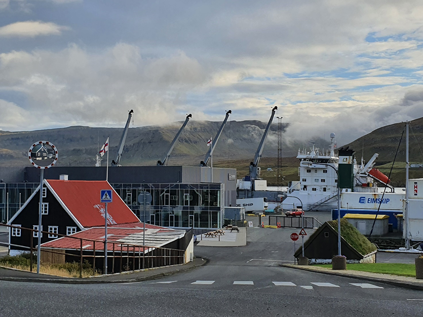
The recent and large pelagic fish factory in Tvøroyri with the historical Trade Monopoly building in the foreground.
Photo: Rasmus Steintórsson Biskopstø.
In the same way, the production of farmed salmon, and smolt, is projected to grow dramatically in Vágur (see the next section on aquaculture). Although the perception in both Tvøroyri and Vágur is that they are no longer fisheries villages, the reality is that more fish biomass than ever goes through the new and emerging local value chains. Profits and control over production, however, is increasingly non-local. The development that is discernible in Tvøroyri and Vágur is therefore a change in the fish value chains, where the production is becoming more resource intensive and centralized.
Aquaculture
As fisheries are declining, aquaculture is increasingly seen and promoted as the alternative to wild fish catches. This is apparent at the regional and global levels in the blue economy strategies of institutions such as the UN (FAO), the EU, and the Nordic Council of Ministers. Support for aquaculture is also evident at the local and national levels in the Faroes. Salmon aquaculture is already so important for the Faroes that the health of the salmon farming industry is perceived as equivalent to the health of the Faroese national economy. Production of farmed salmon is estimated to be the highest in the world, on a per capita basis, at 1.5 metric ton for every Faroese inhabitant in 2017 (Hovgaard & Bogadóttir, 2020).
Currently, Bakkafrost has all the potential licences available for salmon farming in Suðuroy. The single exception is Fámjin, where the company Tari has recently received a licence to start operation of a land-based seaweed farming facility (see Map 4.3). Bakkafrost has reported that they view Suðuroy as an important element in their growth strategy, with a plan to increase production to 15,000 tons of farmed salmon annually, which would correspond to production of more than 3 tons per every Suðuroy inhabitant. One element in this strategy is a planned smolt plant that Bakkafrost will construct at the Ónavík site in Vágur municipality (see Map 4.3). Operations in Ónavík are planned to begin in 2024. The smolt plant is expected to re|quire 12,000 cubic metres of production space, covering 10,000 square metres, and to employ about 10 people to operate the plant. Smolt production is expected to be around 3 million smolts annually, which are to be released into in open net cages in Suðuroy’s fjords. Bakkafrost also reports that expected total employment in Suðuroy is approximately 100 people (Bakkafrost, 2019; Bakkafrost, 2020; Hansen, 2019).
To conclude, while biomass production in Suðuroy of farmed fish is projected to grow dramatically in coming years, ownership and profit is now non-local. After pressure from the municipal authorities in Vágur however, a demand that fish farmed in Suðuroy should also be processed on the island has been entrenched in law and will secure employment opportunities locally. These employment opportunities may, however, be mostly seasonal.
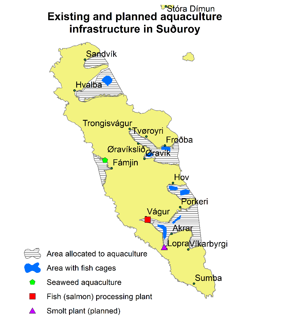
Map 4.3: Fish Farming areas in Suðuroy.
Source: Faroese Environment Agency (us.fo); Map produced by Ragnheiður Bogadóttir.
Tourism
Visit Suðuroy, the official tourism office in Suðuroy, has two local offices, one in Tvøroyri and one in Vágur. Both municipalities work with and aim to develop tourism in the area, and although official statistics are not available on tourism sector employment or tourist visits to Suðuroy, tourism is increasing. During the COVID-19 pandemic, when people were not able to travel abroad, the number of visits to Suðuroy reached record highs. In 2020, 10,000 overnight stays were registered in Vágur.
The investment in infrastructure such as the indoor swimming facilities, the sports hall, and the sports college school in Vágur serve to attract both foreign and domes|tic tourists, and the increasing capacity to house visitors enables the rapid growth in tourism. However, there are still relatively few full-time jobs in the tourism sector.
Traditional/subsistence economy
While industrial fisheries and the Faroese marine environment are integrated into global value chains, the local subsistence economy has largely remained a separate production and distribution sphere. In many ways, the former land tenure system is still the organizing principle of terrestrial land use in the Faroes. A significant proportion of this locally produced food is directly consumed or exchanged and distributed through kinship networks and therefore never enters the formal monetary economy. Some local produce is sold on local markets or supermarkets, but still only on the local Faroese market. In this sense, a large part of Faroese agriculture may be considered a separate sphere of exchange (Sillitoe, 2006), or a diverse/alternative economy (Gibson-Graham et al., 2013). Ethnographically, the analytical tool of separate spheres of exchange, is used to describe how economies are often heuristically separated into different spheres. In each of these spheres, behaviour and exchange is organized according to different moral principles and values (Bohannan & Bohannan, 1968). More recent literature has stressed how separate economic spheres can also function as protective barriers for subsistence economies, preventing subsistence goods from being monopolized and exchanged on the global market, and thereby increasing local resilience and global sustainability (Sillitoe, 2006; Hornborg, 2017).
One important element of the local subsistence economy is sheep rearing. The ’outfield’ belonging to Tvøroyri municipality, which means the grassland used for pasture beyond the ‘infield’, are reported to carry 2,934 mother sheep, and in Vágur, the outfields are reported to carry 2004 mother sheep (Thorsteinsson, 2021). Although traditional sheep rearing is often described as a hobby, in contrast to the commercial and industrial agricultural sector, it contributes significant amounts of animal protein to the local diet. If we use a simple calculation model based on the whole of the Faroes stating that a system with 70,000 mother sheep will produce 50,000 sheep for slaughter each year, the contribution of sheep meat would be 22 kg annually for every inhabitant in Tvøroyri municipality and 19 kg for every inhabitant in Vágur municipality (see calculation model in Bogadóttir, 2020).
However, even if local produce is not exported, agricultural production is to an increasing extent dependent upon outside resource flows, such as imported animal feed and chemical fertilizer. Locally produced food is also increasingly important in the tourism industry, and many see the tourism market having the potential for making local food production a viable full-time occupation.
The importance of fish and fisheries in the two communities of Tvøroyri and Vágur has also meant that people have had easy access to this fresh and healthy resource in their household/subsistence economy. It is unclear to what extent this access and availability has changed, partly because of altered value chains. A common observation is that local people are less inclined to fish in local fjords, because of the expansion of aquaculture in the fjords, and the marked decline of certain species, particularly cod and saithe.
When asked about the importance of the local subsistence economy, informants in both Tvøroyri and Vágur state that this is of great importance, and some state that the informal food distribution economy is perhaps the most important reason for people choosing to live in Suðuroy. Although the informants stress the free food, the reciprocal ties and social cohesion that is reinforced through continual exchanges of food is undoubtedly implicit in the articulated importance of the “free dinner”.
Other food production
Tvøroyri municipality arranges a yearly Autumn Festival with a focus on locally produced food. Participants at the festival were, among others, founders of the Tari company, which produces seaweed for human consumption. Tari is an initiative to farm seaweed and to develop a more sustainable aquaculture industry. The company has recently acquired a licence to operate a land-based seaweed production facility in Fámjin (see Map 4.3). The participants at the festival also included founding members of the Matkovin initiative,[1]See www.matkovin.fo which is a newly established web portal aiming to establish connections between local, small-scale food producers and consumers to create a market for local and artisanal food production. Two food producers from Suðuroy are registered, one in Vágur (Nes) and one in Tvøroyri. The company from Tvøroyri is Ra-fish, which is operated by a local family using a small fishing vessel. Only a small number of people still practice small-scale fisheries, útróður, in Suðuroy or the Faroes. The Matkovin website reports that the company has been established to preserve the occupation, as well as the knowledge associated with small-scale fishing. Small-scale artisanal fisheries may be a sustainable way of capturing local marine resources for the benefit not just of the global community, but also of global food security. Útróður is described as a dying occupation and industry because it is not a controlled production process fitting a modern lifestyle, but determined by weather, currents and seasons. In Vágur (Nes), the small farm Nesgarður is an example of a young family which has taken over a farm and aims to make artisanal and traditional food production (mainly of sheep, cattle, and geese) a full-time occupation.
Footnotes
- ^ See www.matkovin.fo
4.6 First conclusions on the resilience of coastal communities
It is clear from the historical and contemporary data presented in this chapter, that the integration into global value chains has been a defining aspect of the developmental trajectories of both Tvøroyri and Vágur. Both communities became centres in the emerging industrial fishing industry in the Faroes, an industry that continued to grow and develop throughout the twentieth century. With the decline of demersal fish stocks, and the growing importance and influence of other marine industries, the Faroese blue economy is clearly following the global trend of “fishing down marine foodwebs” (Pauly et al., 1998). With these changes in environmental and political circumstances, pelagic fisheries and aquaculture now dominate the political and financial landscape. Both case communities have had to adapt to these changing circumstances but have done so in different ways. Tvøroyri has attracted non-local capital to make investments, and as a result is today dominated by a pelagic industry that is mainly non-locally owned. The infrastructure associated with this industry is very energy intensive and specialized; it is also quite dominant in the local landscape. The industry provides labour opportunities, but the local employment opportunities associated with the industry are to a large degree seasonal or part-time, and do not provide enough income security and stability for families. In the case of aquaculture, especially salmon farming, the same tendencies are discernible. The prospective smolt plant in Vágur will be the largest investment ever made in the municipality, and it will require a substantial area of land in addition to local freshwater resources. Moreover, energy requirements for onland fish farming are very high, which means that the push for the development of renewable (local) energy production will most likely intensify and come into conflict with other forms of land use. The waste production associated with such large-scale fish farming will also be substantial. Today energy production on the Faroes is a combination of diesel stations (230 GWh in 2018), hydro power stations (104 GWh in 2018) and windmills (53 GWh in 2018).[1]See www.sev.fo
From a resilience perspective, the involvement of local communities in the emerging pelagic fisheries and salmon farming value chains may be seen as one element in a diversified local economy, as a way of securing a portion of income and employment opportunities from these profitable industries, in return for the land and energy resources they require. It may also be seen as a strategy that erodes local resilience as it is outside local control and depends on resource flows that may be cut off, depending on political, environmental, and global market fluctuations. The centralization and intensification of resource use also tends to reduce diversity in fish value chains, and thereby flexibility and resilience (Symes et al., 2015), which may occur through the displacement of alternative practices, such as whelk and lobster fisheries. From a sustainability perspective, these new and dominating value chains are heavily energy and resource intensive and add to the energy and material footprint of the economy, rather than reducing it. In other words, they are rooted in a paradigm that pushes “profit-driven, high through-put production” (Carr & Gibson, 2016).
Overall, we see changes in fish value chains that intensify local resource use, while reducing local involvement, ownership, control, employment, and diversity. In this sense, the two cases of Tvøroyri and Vágur serve to illustrate a commonly identified trend where peripheral areas experience the dual process of increasing natural resource extraction and outmigration of people. As such, the cases of Tvøroyri and Vágur are interesting cases to study the strategies adopted in communities for coping with, or even counteracting, the forces driving these trends.
One important and effective strategy is investment in public sector institutions that provide the local communities with basic public welfare services and skilled labour opportunities. Another important aspect, which is often overlooked in formal analysis, is the diverse economy underpinning formal economic and political structures. This underpinning base is continually reproduced through a mix of formal and informal economic practices, such as sheep rearing, fishing, or the knitting of clothes, which are exchanged between members of society to reproduce and renegotiate social ties and relations. These practices can also be understood as locally grounded “cultures of making” (Carr & Gibson, 2016). What characterises these cultures is not so much the distinction between craft production versus other modes of production, but rather the mobilization of local resources for the benefit of the local community. The mobilization of social capital may provide the community with other forms of capital or goods. The conscious efforts made in Vágur to create a “new economy” (Carr & Gibson, 2016), focusing on experience, education, and tourism, is perhaps best understood in this light, as the vision has materialized in an infrastructure that attracts visitors and tourists, but that is primarily of benefit to the local community. Páls Høll, the indoor swimming facility, is often used as an example of the role of social capital in the Faroes, as much of the construction work was carried out by local volunteers. The theoretical implications of developments in Vágur go beyond the question of maintaining population or employment in peripheral local communities, and into discussions of how people can act collectively in their specific geo-social positions in an age of socio-ecological crisis (Latour, 2018). Balancing local economic activity with global value chains is a challenge which preoccupies both citizens and policymakers in Tvøroyri and Vágur. Pursuing solutions may be a complex and unpredictable endeavour. What the results from our two cases indicate is that many of the existing and emerging local value chains are ecologically sustainable; they support local well-being and enhance community resilience. But it is just as clear that these local communities engage in global value chains that are ecologically unsustainable. Rather than asking how local communities may benefit from global value chains, the question to put forward is perhaps how local control and perspectives can be an element in the transformation of unsustainable global value chains.
Footnotes
- ^ See www.sev.fo
References
Apostle, R., Holm, D., Hovgaard, G., Høgnesen, Ó. W. & Mortensen, B. (2002). The Restructuration of the Faroese Economy: The Significance of the Inner Periphery. Samfundslitteratur Press.
Bakkafrost. (2019). Annual Report 2019. https://www.bakkafrost.com/media/2356/bf_annualreport_web_2019.pdf
Bakkafrost. (2020, April 23). Bakkafrost releases smolt in Suðuroy. https://www.bakkafrost.com/en/about-us/news/bakkafrost-setur-smolt-ut-i-suduroy/
Bogadóttir, R. (2020). The social metabolism of quiet sustainability in the Faroe Islands. Sustainability, 12(2), 735.
Bohannan, P. & Bohannan, L. (1968) Tiv Economy. Northwestern University Press.
Carr, C. & Gibson, C. (2016). Geographies of making: Rethinking materials and skills for volatile futures. Progress in Human Geography, 40(3), 297–315.
Danielsen, R. & Agnarsson, S. (2018). Fisheries policy in the Faroe Islands: Managing for failure? Marine Policy, 94, 204–214.
Ellefsen, H. & Bromley, D. W. (2021). The quest for fisheries governance: Lessons from the Faroe Islands. Elem Sci Anth, 9(1), 00115.
Gaini, F. (2015). Wherever I Drop Anchor. Faroese Teenagers’ View on Home and Migration. In Fróðskaparrit, 62. Faroe University Press, 52–69.
Gibson-Graham, J. K., Cameron, J. & Healy, S. (2013). Take back the economy: An ethical guide for transforming our communities. University of Minnesota Press.
Hagstova Føroya. (2021, February 10). An excess of births and positive net migration led to significant population growth in 2020. https://hagstova.fo/en/news/excess-births-and-positive-net-migration-led-significant-population-growth-2020
Hansen, U. L. (2019, January 19). Byggja smoltstøð í Lopra. Kringvarp Føroya. https://kvf.fo/netvarp/sv/2019/01/14/20190114bakkafrost
Holm, D. (2009). Hvar endaðu tey øll? Kanning millum miðnámsskúlanæmingar í Suðuroynni árini 1976–2006. Working paper (24), Granskingardepilin fyri Samfelagsmenning. https://setur.cdn.fo/media/5045/arbeidsrit_24-2009.pdf?s=iAm6J50_39vWa5UqFt6XEBfc3j0
Hornborg, A. (2017). How to turn an ocean liner: a proposal for voluntary degrowth by redesigning money for sustainability, justice, and resilience. Journal of Political Ecology, 24(1), 623–632.
Hovgaard, G. (2001). Globalization, embeddedness and local coping strategies – a comparative and qualitative study of local dynamics in contemporary social change. PhD thesis No. 29, Forlaget Samfundsøkonomi og planlægning.
Hovgaard, G. (2019). Fattigdom og den markedsliberale orden. Elementer af færøsk socialhistorie 1767–1855. Historisk Tidsskrift, 119:2, 407–434.
Hovgaard, G., & Bogadóttir, R. (2020). Mellem Laks, Lus og Putin. Om erhvervsøkonomisk succes, storpolitik og bæredygtighed. Økonomi & Politik, 93(4), 73–85.
Isholm, E. (2020). Fiskivinnan sum broytingaramboð hjá amtmanninum. Fróðskapur.
Joensen, J. P. (1987). Fra bonde til fisker: studier i overgangen fra bondesamfund til fiskersamfund på Færøerne. Føroya Fróðskaparfelag.
Latour, B. (2018) Down to Earth: Politics in the New Climatic Regime. John Wiley and Sons.
Mortensen, A. (1993). Bátsbandið. Bátshaldsskipan føroyinga fyri 1865 og rættarstøða hennara. Fróðskaparrit, 41.
Pauly, D., Christensen, V., Dalsgaard, J., Froese, R. & Torres Jr, F. (1998). Fishing down marine food webs. Science, 279(5352), 860–863.
Sillitoe, P. (2006). Why spheres of exchange? Ethnology, 45(1), 1–23.
Svartá, M., Hovgaard, G., Bogadóttir, R. & Hytönen, M. (2020). Faroe Islands. In M. Hytönen (Ed.), Local knowledge in nature conservation management. Situation in Finland, Sweden, Norway, Iceland, Greenland and the Faroe Islands. Natural resources and bioeconomy studies 14/2020, (52–55). Natural Resources Institute Finland. https://jukuri.luke.fi/handle/10024/545617
Symes, D., Phillipson, J. & Salmi, P. (2015). Europe’s coastal fisheries: instability and the impacts of fisheries policy, Sociologia Ruralis, 55(3), 245–257.
Thorsteinsson, K. (2021). Hagar og seyðamark. Heimabeiti.
Chapter 5: Value chains and social resilience in two Greenlandic towns
Joan Nymand Larsen, Gestur Hovgaard & Jón Haukur Ingimundarson[1]Joan Nymand Larsen and Jón Haukur Ingimundarson were also supported by funding received from the EU H2020 project JustNorth, grant agreement no. 869327.
Footnotes
- ^ Joan Nymand Larsen and Jón Haukur Ingimundarson were also supported by funding received from the EU H2020 project JustNorth, grant agreement no. 869327.
5.1 Introduction
In this chapter we focus on the towns of Narsaq and Nanortalik located in South Greenland. Our key interest is with the changes in the most important value chains in the period since 2000, and how these changes involve a variety of actors at the local and national levels.
The towns and villages along the coasts of Greenland have subsisted through a combination of fishing, hunting and small land-based trades. For decades fishing and the fishing industry – a highly globalised business – have been of key importance to the Greenlandic economy and its scattered settlement structure. Although considered remote places, Greenlandic towns and settlements are in many ways integrated into national and global commercial value chains with significant impacts on economic sustainability at the local level.
Overall, these coastal communities can be described by some typically challenging characteristics: small size in terms of population and economy, remoteness, high costs of access by air and sea, a narrow renewable and non-renewable resource base, limited economic diversification, and a volatile and often stagnating or declining economy. As of 2021 there were 13 towns with a population greater than 1,000 in Greenland; 14 towns and settlements with a population between 200 and 1,000; 14 settlements with a population between 100 and 200; and 30 settlements with a population of less than 100. The smaller communities also have many social challenges, including high rates of youth unemployment and out-migration. But they are also places experiencing innovation and re-structuring, with renewed hopes for greater internal resilience. Narsaq and Nanortalik are interesting cases of how towns located at the geographic and social margins work to cope with the myriad of structural challenges facing many small northern and arctic communities today.
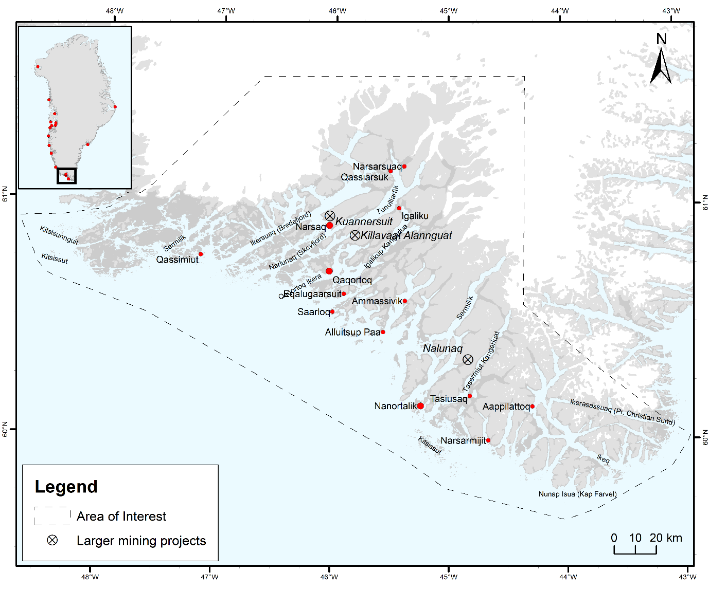
Map 5.1: Kulajjeq Municipality with towns and settlements.
Source: Fritt-Rasmussen, J., Raundrup, K. & Mosbech, A. (Eds). (2022).
In the following we first describe our field methods and provide the historical background of these two local communities and the broader context they are part of, their demographic changes, their local economic sectors, and the main trends in local value creation. Finally, we briefly reflect on the prospects for sustainability and local resilience in South Greenland.
5.1.1 Methods
Data collection and analysis began with an extensive reviewing of the literature, followed by several scoping meetings in Nanortalik, Narsaq, and Qaqortoq which was then followed by two intensive fieldwork seasons during which interviews and observations were conducted and original data was collected.
During the first fieldwork period (September 2021) survey data was collected in the towns of Qaqortoq, Nanortalik and Narsaq. A comprehensive survey (in Kalaalliut and Danish) was administered on-site. Sixteen semi-structured interviews (duration 1–2 hours each) with one or two individuals at a time were conducted in Danish, English, Kalaallisut and Icelandic at all three sites. Interviewees were people involved in fisheries, hunting and small-scale fishing, tourism, entrepreneurship, food processing, education, agriculture, vocational training, secondary school education, labour market administration, cultural and natural heritage management, and higher town as well as municipal administration. Other qualitative research activities included community consultation meetings (25 participants; open invitation; two hours in duration) in Nanortalik and Narsaq; three workshops with young adults aged 17–32 years; one workshop with instructors of disadvantaged youth; and one interview with a group of elementary school teachers.
The second fieldwork period (March 2022) took place in Nanortalik and Qaqortoq. Emphasis was on intensive follow-up interviews with those we had already developed a strong rapport as well as interviewing new informants. Twenty-one interviews (1–4 hours each) were conducted with 14 individuals, including those belonging to the aforementioned stakeholder categories, professional and social groups, as well as individuals involved in providing church service, renewed gold mining development, management of public housing, health care, and large-scale retailing and supermarket services.
5.2 Historical background
The Danish colonial period in Greenland began 300 years ago, and formally ended in 1953 when Greenland became a county within the Kingdom of Denmark. However, with the end to the colonial period, there were no real changes in terms of administrative ties, as Denmark continued to govern Greenland using the same Danish civil servants and similar administrative arrangements as before. From the end of colony status until 1979, when Greenland obtained Home Rule, there were two phases of economic development policies implemented in Greenland by Denmark– the G-50 and G-60 policies (Larsen, 2002; Larsen, 2004).
The overall objective of the first development phase (G-50) beginning in the early 1950s was to create greater equality between Greenland and Denmark, improve the standard of living, develop a larger private sector, and to work towards a higher degree of economic independence for Greenland. The Danish administration sought to achieve this through a centralization policy involving population concentration, imported Danish capital and personnel, privatization of state-run operations, and investment in infrastructure and a modernized fishing industry. However, until the mid-1960’s, economic development in Greenland was disappointing, not only because Greenland lacked educational facilities, but also because income and profits generated often leaked out of Greenland and made their way back to Denmark (Larsen, 2004). The centralization policy promoted through G-50 meant the migration of a substantial part of the population away from the scattered villages and resettlement along the coast of Greenland into larger centres (Larsen, 2002).
The second phase of economic development policy (G-60), implemented in 1964, continued many of the key features of the G-50. Expansion and modernization of the fishing industry through increased state activity was a central component, and largely a response to the disappointing results of efforts to increase privatization. The role of the Danish state included establishing the technical and financial requirements for a more centralized and industrialized fishery. Viemose (1980) has argued that this policy caused a decline in the number of small fishermen, and an increase in dependence on a money economy for a growing number of wage earners. This, and the more technical methods of production, often resulted in Greenlandic workers being left with less skilled, low wage work.
Home Rule, granted in 1979, followed the failed promises of the development programs. In particular, the control of trade and commerce by the Royal Danish trade monopoly (KGH), the persistent socio-economic stratification along ethnic lines, and the overwhelming Danish influence in the design of the school system, contributed to Greenlanders´ increasing demand for Home Rule.
One of the key policy goals following Home Rule was to maintain a decentralized settlement structure and to achieve regional and distributional objectives of greater income equality (Poole, 1990). Efforts were focused on developing a more diversified economy, i.e., tourism industries and mineral resources, as well as other land-based activities, such as agriculture and local arts and crafts. Still, a key objective in the 1980s was to modernize Greenland´s fishing industry to enable the exploitation of increased fish stocks. This included modernization of fish processing plants in towns and settlements and improved access to low-interest government loans for purchasing trawlers and fishing boats (Poole, 1990; Danielsen et al., 1998). Also, prices paid to the fishermen were fixed and guaranteed by the Home Rule government to stabilize incomes and ensure a steady fish supply (Statistics Greenland, 1997).[1]Greenland left the EEC in 1985 and obtained OLT status (overseas territory in relation to the EEC). Greenland obtained duty free access to EEC markets in exchange for EEC fishing rights. The fishing protocol allocates fishing quotas to the EU and as compensation the Greenland government receives a fixed amount of financial compensation every year. In 1990, the fish harvesting, processing and marketing operations of the Home Rule owned company, Royal Greenland Inc., were converted to commercial operations. This was the first step, at a national level, to develop a business community operating under market conditions. Commercialization of these, and other Home Rule owned enterprises, was undertaken to separate political and economic activities, and thereby to make social assignments, such as maintaining production, supply, and employment in outlying districts, the responsibility of separate, non-commercial organizations (Larsen, 2004).
The main political goal of this reorganization was to encourage a financially dependent Greenlandic economy to free itself from Danish state subsidies. This goal may require further economic diversification, but the remedies go far beyond strict economic or technical ones. Social and environmental sustainability to underpin such processes is required. While economic growth has been relatively steady for several years, poverty, inequality, and a lack of education and technical skills continue to be among the main challenges that distort the labour market, and hinder economic diversification (Grønlands Økonomiske Råd, 2021). Moreover, the pressure for institutional renewal is substantial because self-government, obtained in 2009, exerts further pressure to reduce dependence on the Danish annual block grant (Larsen, 2010). The public sector in Greenland is large – about 60% of GDP – and it accounts for more than 40% of total employment (Grønlands Økonomiske Råd, 2021, p. 27).
Footnotes
- ^ Greenland left the EEC in 1985 and obtained OLT status (overseas territory in relation to the EEC). Greenland obtained duty free access to EEC markets in exchange for EEC fishing rights. The fishing protocol allocates fishing quotas to the EU and as compensation the Greenland government receives a fixed amount of financial compensation every year.
5.2.1 Nanortalik and Narsaq
With fisheries as the economic backbone, Nanortalik and Narsaq have felt the changes in fisheries through time, including the modernization phase introduced by the Danish administration prior to Home Rule and self-government. But their local and economic histories began long before government recommendations about comprehensive modernization and centralization in Greenland. The country was occupied by Inuit and Norse people for more than a thousand years. The Norse had permanent settlements before the year 1000 which survived until their disappearance around 1400. Today five areas known for their Norse and Inuit farming in South Greenland are inscribed on the UNESCO World Heritage List under the common name Kujataa Greenland (UNESCO, n.d.).
Nanortalik (meaning the place of the polar bears) is situated on Nanortalik Island, close to the southern tip of Greenland. Along with Nanortalik town there are a small number of settlements and farmsteads in the area that formed Nanortalik municipality prior to municipal restructuring. The town is surrounded by two mountains, Qaqqarsuasik (the large mountain) and Quassik (the raven mountain). During spring and early summer, the ocean around Nanortalik is packed with ice. The early modern history of Nanortalik can be traced back to 1770 when the locality was called Nennortalik. A trading station was built in 1779, and was later moved, in 1830, to where the local museum is now located. Early history was characterised by small scale fishing, and seal and seabird hunting. As sea ice prevents fishing for several months of the year, fishing in the nearby coastal area has mainly been practiced by smaller boats. A graphite mine operated some 20 km from the town, from 1911 until 1925, when it was abandoned.
A basic pillar of the Nanortalik economy is the harbour area, with its small-scale fishers and fish processing. There are small shops in the centre of town, a hotel, a tourism office, a museum, a few service facilities, and a municipal office. The municipal office provides a link between the local residents and the municipal headquarters in Qaqortoq. There is also a heliport and sea transportation, with regular, small scale ferry traffic connecting local residents with other places in South Greenland. Future plans include a 600-metre-long runway for airplanes and an extension of the existing harbour. Like many other towns and settlements in Greenland, Nanortalik has experienced major economic fluctuations, with the 1970s and 1980s remembered as “the good old days” when there were plenty of jobs in the local fish processing factory.
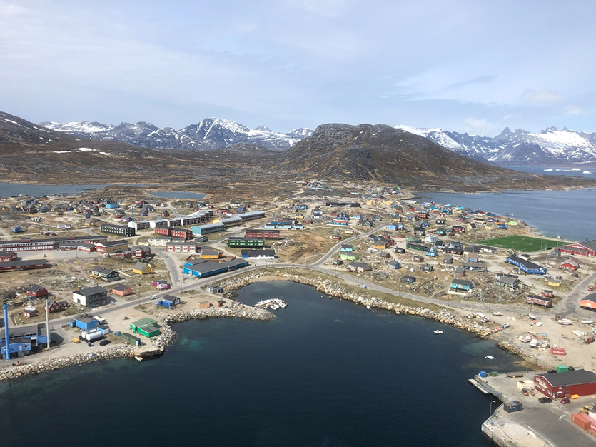
View from above of Nanortalik that shows the small boat facility and local fish market in the middle foreground and the main harbour area in the lower-right corner.
Photo: Gestur Hovgaard.
The population of Nanortalik has been declining over the past decades. The smaller villages have been especially hard hit by out-migration that has been increasing in recent years. A walk through the town of Nanortalik reveals buildings and infrastructure in significant decay. Some apartment blocks, which are not necessarily badly constructed, are simply left with plates covering their windows. Locals refer to these plate-covered windows as “municipality amalgamation windows”, a term coined by locals to express their view of the impact and aftermath of Nanortalik’s amalgamation into the larger Kujalleq municipality in 2009.
Narsaq (meaning the flat field) is located on a flat area of the Narsaq peninsula. The peninsula is bordered by the straits of Tunulliarfik (Eriksfjord) and Ikersuaq, both of which are rich in animal life. Originally called Nordprøven, Narsaq was established as a trading post in 1830. The locality was chosen because of its deep-water harbour, which allowed for ocean going vessels. In the early colonial years, continental goods were traded for blubber and seal skins by local seal hunters. The seal hunting economy continued until approximately 1900, when fisheries gradually took over.
The backbone of the Narsaq economy consists of fisheries, tourism, and agriculture. Kunannersuit mountain, with some of the world’s largest deposits of rare earth elements, is located just a few kilometres outside of town. Earlier plans for uranium mining were shelved after major local resistance in 2021. As in the case of Nanortalik, Narsaq also has a hotel and other types of accommodation, a museum, a range of services, and transportation by air and sea. The transportation links include closer and better access to Qaqortoq, the municipal centre, and Narsarsuaq, with its international airport. In addition, Narsaq has a number of other economic activities making it slightly more diversified than Nanortalik, including its own brewery, a food college, and a slaughterhouse.
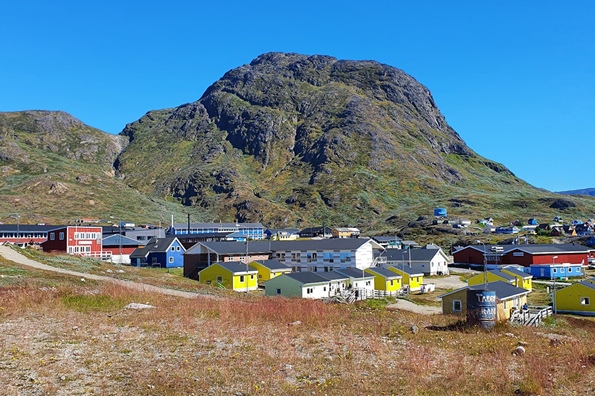
View of a residential area in the town of Narsaq.
Photo: Joan Nymand Larsen.
The population of Narsaq was small until the end of colonial rule in 1953. Significant population growth occurred after the introduction of the G-50 policies, with the first Royal Greenland shrimp and fish processing factory established there in 1953. Narsaq became an independent municipality in 1959, but like Nanortalik, it was part of the amalgamation process in 2009.
As in the case of Nanortalik further south, locals in Narsaq also consider the 1970s and 1980s as the good times, especially because the now underused shrimp factory was fully operating back then.
5.3 Demographic changes
The recent demographic trend has been one of a declining and ageing population. Greenland reached a population of 50,000 around 1980, up from about 10,000 inhabitants in the early 1900s there has been a minor growth in the current population, to about 56,000.
Figure 5.1: Population development in Greenland, total and by gender.
Source: Statistics Greenland (stat.gl).
Like other regions of the Arctic, Greenland has higher ratios of men to women locally (approximately 100 men for every 90 women). Also, as in other regions of the Arctic, Greenland has had a negative net migration over the last twenty years, and high but declining birth rates.
Figure 5.2: Net migration Greenland, 2000–2021
Source: Statistics Greenland (stat.gl).
A general demographic trend in Greenland is the growth of the larger towns – such as the capital Nuuk, and Aasiaat and Ilulissat – while most other places are in decline, though with some variations.
Figure 5.3: Population development based on 2018 municipal structure.
Source: Statistics Greenland (stat.gl).
Greenland follows similar urbanization trends as can be observed in other modern societies. Today, more than 50% of the population live in the five municipal centres of Nuuk, Sisimiut, Ilulissat, Aasiaat and Qaqortoq, with Nuuk having 34% of the total population. At the same time the enormous size of the country, combined with its small population, creates special challenges for socio-economic development. Significant local and regional differences can be observed in the gender distribution, ageing, schooling and educational attainment, household income, and the importance of traditional activities.
Figure 5.4 shows population development in the three towns of Nanortalik, Narsaq and Qaqortoq, as well as for Kujalleq municipality overall. For both men and women, the trend has been one of a declining population over the past couple of decades.
Figure 5.4: Number of inhabitants in Kujalleq municipality, Qaqortoq, Narsaq & Nanortalik.
Source: Statistics Greenland (stat.gl).
Kujalleq is the smallest of the five municipalities in Greenland, and as illustrated by Figure 5.4, the population has been declining quite markedly over the period from 2000 to 2020, with the population decline being particularly high in Nanortalik, and larger for women than for men. In addition to the three towns, there are 11 smaller settlements in the municipality, as well as 38 sheep farming settlements (Kommune Kujalleq, n.d.).
Figure 5.5a: Nanortalik net migration 2000–2020.
Source: Statistics Greenland (stat.gl).
Figure 5.5b: Narsaq net migration 2000–2020.
Source: Statistics Greenland (stat.gl).
The age distribution in the towns of Nanortalik and Narsaq is characterised by a decline in the younger age cohorts, and a relative increase in the older population groups, especially in the 50 years and older cohort. These changes are more pronounced in Nanortalik than in Narsaq, also reflecting a relatively more pronounced push factor than in the case of Narsaq and Qaqortoq. The population in Narsaq and Nanortalik is not only decreasing, but also getting older. This has created a serious gap, as demonstrated among age groups that challenges community viability (Figures). The absence of young families and a productive and larger workforce is impacting the level of public services as well. A critical challenge is the declining youth cohort, and in particular the lack of employment and educational opportunities, as well as recreational possibilities. Both towns have critical housing shortages and a lack of good school and day care facilities which complicates efforts to attract and retain newcomers, or encourage younger families to stay locally.
The demographic trends in Narsaq and Nanortalik reflect a number of factors. First, young people must move to Qaqortoq for further schooling beyond primary school, including high school, trades, and technical school. Before that they may have moved to Nanortalik or Narsaq from smaller places in the vicinity to finish the last years of their early schooling. After high school they may choose to move onwards to Nuuk or other larger towns or abroad for higher education or training. A significant share of the youth that leave their hometown for educational purposes decide not to return to make a living there. Young people who chose to stay typically have limited educational, training or job opportunities, or do not have the competencies and, more importantly, the safety net and independence needed to support a job (Tróndheim & Berliner, 2017; Lynge, 2017). Although the general level of education is rising in Greenland, one third of Greenlandic youth in the age group 16 to 25 were either unemployed or outside the educational system in 2018 (Jensen & Pedersen, 2020). In Narsaq and Nanortalik about 70% of the population have only primary school education, while the average in Greenland is approximately 60% (Statistics Greenland, 2019). Support for competence improvement is typically done through stays at folk high schools (folkehøjskole) in Denmark or Greenland, or via local educational programs for school dropouts, and for others who have decided to return to school to complete their elementary school degree, for example via the “Majoriaq” schools, which are schools that provide counselling and teaching for career purposes, of which there is one in Narsaq and one in Nanortalik. The youth describe Majoriaq as a good opportunity that for many has been a help to get back on track, but they worry about the frequent lack of training and opportunities for apprenticeships. Generally, employment and business opportunities are scarce, especially for the younger generation, and there tends to be a lack of professional services, particularly for younger families. While many residents of Nanortalik describe the town as a good place to live, they also express concern about what kind of future their children might have if they choose to stay. Many residents perceive the standard of primary education to be lower than elsewhere, and they often express concern and frustration over a lack of teachers, quality daycare and kindergartens, as well as limited sports and recreational activities.
5.4 Municipal organization
As in other Nordic countries, municipalities in Greenland are the central units in terms of local democracy and citizen influence on their local society. Although they may not be responsible for as many tasks as their Scandinavian counterparts, the municipalities represent local authority and provide key technical, social, and educational services for their citizens. Health care provisions are largely a central government responsibility.
Greenland’s municipal structure dates to 1911, when its first administrative division was made, with the creation of 62 municipalities. The municipalities had advisory functions and a few social responsibilities regarding poverty relief and the like (Olsen, 1999, p. 21). Although the administrative structure was adjusted slightly over time, more fundamental changes first occurred in the early 1950s. Nineteen new municipalities were created, along with a wider range of responsibilities (Olsen, 1999, p. 26). The municipalities acquired a more central role in the distribution of welfare and local services, in particular after Home Rule was established in 1979. The structural reform that took place in 2009, with the introduction of self-government, produced four enlarged municipalities, with minor additional changes taking place in the years that followed. Until 2018, the municipalities had an intermunicipal organization, Kanukoka. This intermunicipal organization was dissolved on the grounds that the additional administrative layer was regarded as inefficient. The reduction in the number of municipalities raised concerns about the participation and influence of the smaller settlements in political and bureaucratic processes. The rationale behind the reform was clear: larger municipal units would make it possible to transfer more tasks from central to local government, to ensure better and safer services, to gain economies of scale and better use of professional and academic resources (Strukturudvalget, 2005). Like structural changes in the other Nordic countries, the focus was on efficiency (Aalbu, Böhme & Uhlin, 2008).
Five years after the amalgamation, a survey revealed general dissatisfaction with the level of services and the amount of citizen influence in municipal affairs. Dissatisfaction was particularly high in Qaasuitsup and Kujalleq municipalities, with the longer the distance to the new municipal centres, the greater the dissatisfaction (Kjær, 2015). In interviews and discussions with locals in Nanortalik and Narsaq, we collected data that strongly support the results in Kjær (2015). From a practical perspective, the criticism in particular concerns problems with daily social services, the lack of maintenance of roads and the like. From a more general perspective, our informants express a general concern about what they see as a decline in local empowerment. Locals perceive a change in the balance of power, which they argue has left Nanortalik and Narsaq worse off in terms of socio-economic status and political clout. These power imbalances are perceived by many locals to be a root cause for the persistent inequalities in socio-economic outcomes.
The Structural Committee responsible for the 2009 reform was aware of some of the potential weaknesses with enlarged municipalities. To counter a democratic deficit, they suggested councils and boards be established at the local level to provide users of public services with influence over their own affairs (Strukturudvalget, 2005, 18). Given the absence of local specialists, the Committee suggested a structure whereby specialized competences were gathered in one place (Qaqortoq in the case of South Greenland), to provide support for the general competences situated outside the designated centre. Along with new information technology, better training options, and the creation of local service centres, the Committee thought they could reverse weaknesses in the existing system (Strukturudvalget, 2005, p. 21).
The Structural Committee’s plans have met with little success. Much of the frustration one encounters locally in terms of economic development and a lack of citizen influence is attributed to the new municipal structure. This is true even in cases where one can imagine other, more complex causes. The present leadership of Kujalleq municipality is well aware of the social distance among places that has been created since the amalgamation, and they are trying to find solutions. One change is the employment of a ‘Town‘s Chief‘ who has the task of mediating between local residents and the municipal centre. Another new direction is Innovation South Greenland (ISG), a municipal organisation which was established in 2017 with the main goal of fostering economic development and creating greater awareness of opportunities in South Greenland.[1]
Footnotes
- ^ See www.isg.gl
5.5 Changing value chains
The history of economic development along the coast of Greenland is first and foremost characterised by its emphasis on fisheries and investments in fish processing and harbour facilities. Periodic fluctuations in fish stocks and sea mammals have shaped life in the towns and settlements of South Greenland. As in all other districts of the country, the traditional occupation in South Greenland is hunting, especially for the food that the sea provides.
Current development strategies include a strong focus on infrastructure development, including plans for the construction of new airstrips, new road constructions and possible road connections between localities in South Greenland. Beyond this, the emphasis is on economic diversification in key economic sectors; fisheries, agriculture, tourism, mineral resources, and the creative arts (soapstone carving, music, painting, and performing arts).
Fisheries
Coastal fishing from smaller boats, including crab fishing, and hunting for hooded seals, as well as seabird hunting, are main sources of income. Fisheries are regulated by quotas and licences allocated by the government of Greenland. In some cases, the government requires quota holders to supply fish to domestic factories for processing, which creates added value in the form of salaries and tax revenue.
In the 1970s and 1980s, cod and prawn fisheries generated local prosperity, but this changed with the collapse of cod stocks in the late 1980s. In the late 1990s the local fish factory was closed in Nanortalik and remained closed for about a decade. It reopened in 2006 and has gone through several changes in ownership since then. Today, the only industrial fish processing factory in Nanortalik is Arctic Prime Fisheries, with headquarters in Qaqortoq. It primarily deals with Atlantic cod. Arctic Prime Fisheries has taken several important steps towards becoming more efficient, such as installing freezing-thawing facilities which have created more stable employment for the local community; specializing in cod, as opposed to a broader range of fish and fish products; and making decisions to process on certain weekdays, which tend to be more suitable for the on-site labour force. In Narsaq, two fish processing factories have operated, Royal Greenland, and Arctic Prime Fisheries, the latter being the largest Greenlandic seafood company operating in South and East Greenland. The primary species landed in Narsaq is Greenland halibut, along with Atlantic cod.
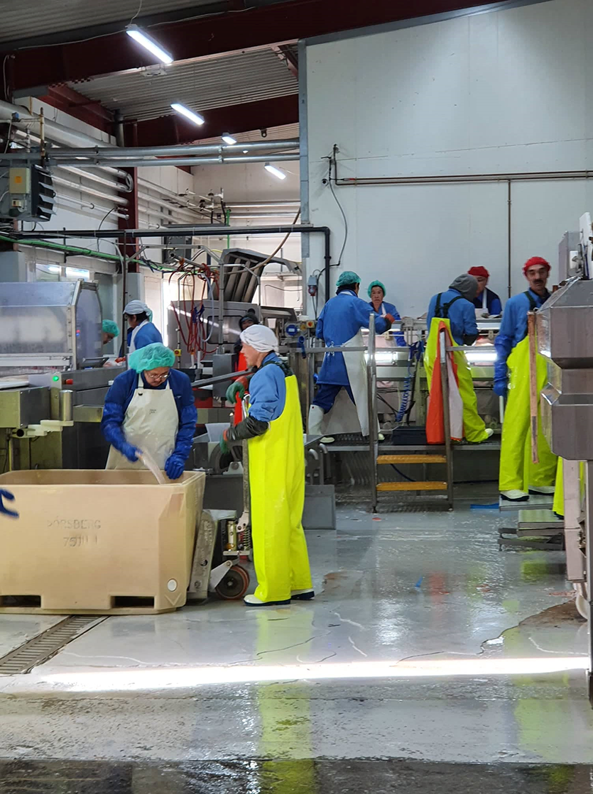
Fisheries remain a vital industry in Narsaq and Nanortalik. The picture shows inside the saltfish factory in Nanortalik which is operated by Arctic Prime Fisheries.
Photo: Joan Nymand Larsen.
Offshore fishing, particularly by EU trawlers that bring their catch to processing facilities abroad, may affect value creation in local communities. The most recent Fisheries Partnership Agreement between Greenland and the EU allows 12 industrial trawlers to harvest large quotas of fish in return for significant annual financial contributions, directly payable to the government of Greenland (Naalakkersuisut, 2021). Royal Greenland, Polar Seafood and Arctic Prime Fisheries also fish offshore, but in some cases the Greenland government sets restrictions on the annual quota licences by stipulating that the domestic quota holders must supply fish to domestic factories for processing. Another key challenge in the value chain is the practice by Royal Greenland of outsourcing some of its fish processing to other regions such as Poland or Canada.
The traditional economy
Traditional activities are important to the populations of Nanortalik and Narsaq. These activities include various forms of harvesting, hunting, trapping, farming, and fishing. As in many other parts of Greenland, these traditional activities make an important contribution to the household economy along with other sources of income, including wage employment, and social transfers from government. Local hunters and fishers share their harvest with their families and other community members. The fish catches that are not sold to local factories are made available at the local seafood market. On a normal day, you may purchase seal, redfish or catfish, with mussels being a delicacy.
Mining
In 1996 new and simpler application procedures for exploration for minerals were introduced in Greenland (Statistics Greenland, Yearbook 1998, pp. 62–63). The mineral resources industry (gold, copper, coal, lead, zinc, precious stones, rare-earth, and uranium) is considered a potential source of future income. Politicians view resource developments as possible answers to the lack of financial resources for the financing of Greenlandic self-government. The Greenland government has guidelines regarding mineral projects with the main objective being: “All mineral projects must be socially sustainable and meet high international standards with regard to financial planning, health, safety, the environment as well as social and cultural initiatives” (Naalakkersuisut, 2016). In 2017 some important changes were introduced that provided for faster processing of mineral licences – a critical step in the government strategy of making Greenland a mining nation. Provisions were also made for small scale mining projects that help local communities to benefit from mineral resource exploration. However, making a mineral resource discovery that is large enough for commercial utilization requires considerable investment, and the effect on employment may be relatively small. Benefits for the local population may also be limited due to potentially large leakages of value created when ownership and control is non-local.
Two mining projects in the areas surrounding Nanortalik and Narsaq are of particular interest. One is the controversial rare-earth and uranium mining project in the mountain Kuannersuit near Narsaq, which was banned in 2021 after years of increasing local resistance and heightened government opposition. The other is the Nalunaq goldmine near Nanortalik. Our interviews with locals show that whereas locals in Narsaq are looking to other activities to create a sustainable future, Nanortalik residents view mining as a potential new source of income that may augment household income.
In recent years, the Nalunaq gold mining has been viewed as having substantial potential. The underground mine is located in the Nanortalik gold belt about 30 km north of the town. The mine operated for a number of years between 2004 to 2013 but closed in 2014 due to declining gold prices. However, with changed market conditions, the mine was reopened in 2022. Barracks for mine workers on rotational schedules have been built using trades people, transport and catering services in the local area. The mining site benefits from access to ice-free, deep-water fjords (Srk Exploration, 2020).
Gold mining could provide Nanortalik with an opportunity for more employment and economic opportunity, and perhaps constitute a basis for greater internal resilience for the local economy. However, its operation may also lead to potential negative impacts, such as pressure on community facilities, and adverse consequences for local culture. The net benefits to Nanortalik may be limited due to potentially small economic multiplier effects, although benefits could be sufficient to make a difference for this small economy. Locals are engaged in activities related to transportation to the mining site and service-related tasks, including cleaning, hospitality, and catering. Interviews with local residents show that the mining project, in its early phase, makes some contributions to local household income, although interviewees also point to the fact that many of these jobs do not require much skill.
The impact of the Nalunaq mine on the town of Nanortalik will not be known for some time. While positive net benefits are possible, the creation of “dependence-at-a-distance” may also result. In looking at labour mobility and the evolution of single industry towns, Storey and Hall (2017) found that commute work has created a new settlement phenomenon – resource dependence-at-a-distance communities. They argue that, as with traditional single industry towns, dependent-at-a-distance communities are vulnerable during resource downturns. There may be advantages to work arrangements involving commuting, with benefits and adverse effects more geographically dispersed. Further, work camps, unlike communities, can be quickly opened and closed, depending on growth or decline. What has been overlooked, however, is the possible concentration of workers elsewhere, creating place-specific problems, albeit at a distance from the resource. In such cases, there will probably be limited obligation for either resource developers or governments to manage such effects. This could be a potential challenge to consider in the case of Nanortalik.
In the case of Narsaq, the once proposed rare-earth and uranium mine was to be located approximately 7,5 km to the north of Narsaq town and 40 km to the southwest of the international airport and settlement at Narsarsuaq. Mining operations would have involved conventional open pit mining. The mine would have produced a rare earth mineral concentrate with fluorspar. Further processing in a refinery would have produced uranium oxide as a by-product for export to foreign markets. The social impact assessment report concluded that there would be a significant number of jobs during the construction and operation of the mine, as well as indirect employment opportunities for Greenlanders and business opportunities for Greenlandic enterprises (Greenland Minerals A/S, 2020). The mining project was expected to generate large capital investments, substantial corporate taxes, royalties and considerable personal income tax. However, the potential negative impacts of the rare-earths and uranium mine would have included the concentration of benefits at national and regional levels, an uneven local distribution of incomes, local inflationary pressures in Narsaq, and possible jealousy among residents of Narsaq related to the distribution of benefits from the project (Greenland Minerals A/S, 2020). The environmental impact assessment report found that the proposed project would not generate any significant impacts resulting from noise or light generated by the project; impacts on marine and terrestrial fauna and habitat were expected to be limited; and the overall impact related dust and emissions would be very low, including very low radiological impacts (Greenland Minerals and Energy A/S, 2019). Many local and regional residents questioned these findings. The population of Narsaq was initially divided on the issues, but eventually 90% of the local population were against its possible start-up prior to its cancellation. Before the mining project was officially banned in 2021 many locals expressed their strong concerns about the proposed project. Some said they would leave Narsaq if the mining project was to ever go ahead, as they feared the very basis for their existence in agriculture, fishing, and tourism would disappear (Larsen and Ingimundarson, 2023). While the project is now banned, it has opened up considerable discussion among locals about alternative futures for the area.
Tourism
Tourism has been a growing industry in Greenland over the past couple of decades. Some challenges have been the relatively short tourist season, the high cost of international and domestic air travel, and expensive local accommodations. In its planning documents on future tourism, the municipality of Kujalleq has highlighted the possible development of year-round, sustainable tourism; a national certification system that addresses quality, safety, and environmental concerns; public infrastructure to support tourism; and education for locals on the value of tourism.
Challenges related to the continued lack of infrastructure and transport networks persist. Road networks require repair and upgrading, and there is a critical need for new and improved airports in the region. The construction plans for three new airports in Greenland – Qaqortoq, Nuuk, and Ilulissat – were approved in 2015 by parliament, with Denmark contributing financing to the airport construction in Nuuk and Ilulissat.
Tourism in both Nanortalik and Narsaq has been growing. While Covid limited tourism during the pandemic, representatives from the tourism industry have reported that many Greenlanders visited Nanortalik during the pandemic, and to some extent counterbalanced the decline in international tourism (cruise and adventure tourism). In both Nanortalik and Narsaq, new and creative ideas are being considered by the tourism operators for expanding through a wider range of tour packages, and greater emphasis on UNESCO heritage activities. Possible tourism challenges, as also highlighted in a tourism study by Rantala et al. (2019), include the pressure of peak seasonal demands on communities and the environment, the perception of tourism as a sector without rewarding, long-term jobs; seasonality; and the use of transient workers. Still, this growing sector is creating important economic benefits for the region.
Agriculture
Agriculture is a growing sector in the municipality of Kujalleq, particularly around Narsaq and in Kujataa. Kujataa consists of five sites featuring significant archaeological remains dating back to medieval Norse society. Today, three of these sites, Qassiarsuk, Ikaliku and Tasikuluulik, are among the largest farm clusters in Greenland, where significant sheep production has taken hold after a hiatus of approximately 450 years. Kujataa was placed on UNESCO's World Heritage List in 2017 and portrayed as “Norse and Inuit farming at the edge of the ice cap”. Given the proximity of the Narsarsuaq international airport, the farmers have benefitted from providing services to tourists during the summer season.
Beginning in the mid-1980’s, initiatives have gradually been implemented to ensure better income for sheep farmers in South Greenland. These supports include construction of large barns for housing and feeding animals; new machinery and facilities for cultivation, harvest and transport; and cooperation between scattered farms; clearing and cultivation of arable land; mapping of vegetation resources and establishment of grazing and winter-fodder units that are separated by natural borders or new fencing; agricultural consultation services; mandatory education and training for farm workers and managers; and the introduction of a standard of 400 animals per farm unit (Landbrugskommissionen, 2014; Rasmussen, 2014).
In Kujalleq, there are currently about 1000 hectares of cultivated land for grazing and feeding sheep and cattle (Naalakkersuisoq for Fiskeri, Fangst og Landbrug, 2020). Approximately 17,000 adult sheep are kept on about 40 sheep farms, and around 20,000 lambs are culled every year, most of them in the EU certified Neqi A/S slaughterhouse and meat processing factory in Narsaq. Since 2013, the number of sheep farms has declined from approximately 60 to 40 farms in 2019, but the number of sheep has remained fairly constant. Isolated, smaller farms have been abandoned because of difficulties in sustaining livelihoods solely with income from farming. Sheep farmers remain dependent on subsidies from the Danish state via the Greenland government and receive approximately 30% of their annual income in the form of direct government funding, which is divided equally among the 40 farms in existence. In addition, the government subsidizes the operation of the slaughter and processing plant in Narsaq by approximately 40%. Farmers in different agriculture sectors can also apply for targeted support for specific projects, such as enlarging their barns or hayfields. The farms face challenges from uncertain weather and topographical conditions which make it difficult to forecast how much imported fodder (barley) and fertilizers should be purchased (Naalakkersuisoq for Fiskeri, Fangst og Landbrug, 2020). In June 2022 local farmers expressed their frustration over insufficient support from government, broken promises, and fears of economic hardship due to increasing costs for fodder, fuel and fertilizer related to the war in Ukraine.
As the climate has become milder and warmer in the last couple of decades, conditions for livestock farming, horticulture and even grain cultivation have improved. Consequently, beef cattle production has recently emerged as a viable agricultural option at four farms, even without government support. Around 50% of these cattle belong to one farmer located near Narsaq. His cattle’s grazing grounds, located in the vicinity of Kuannersuit mountain, are reliably productive.
Beef cattle grazing outside the town of Narsaq and close to Kuannersuit, the site of the controversial rare earth and uranium mining project.
Photo: Jón Haukur Ingimundarson.
Organic horticulture has also been a growing industry in South Greenland, and in 2019, over 100 tons of potatoes were harvested at the five farms that produce for the domestic market. Located near Narsaq, one of the family-owned businesses produces 50% of the Greenland-grown potatoes that are sold in stores. This farmer believes that with some initial government support, Greenland should become self-sufficient in root crops and certain vegetables (Semionsen, 2019).
5.6 First conclusions on the viability of Narsaq and Nanortalik
Nanortalik has been a place with extensive periods of stagnation and decline, as measured by many social and economic indicators. At the same time, there are signs of increasing opportunities, including emerging tourism prospects, the reopening and stabilization of the fish processing plant and the upcoming reopening of the Nalunaq goldmine, and its associated activities. In Narsaq, which has also been in a state of decline, due in part to the closing of a fish processing plant, there are growing opportunities in tourism and agriculture, and increased activities with the Neqi food processing plant as well as with the food college Inuili. Local resistance to the opening of a uranium mine suggest prospects for a better future.
As shown in the case of South Greenland, infrastructure, physical capital, and greater accessibility are fundamental pillars in the internal resilience of a place. The once proposed rare earth-uranium mining project in Narsaq, although now banned and closed, has provided much discussion about what future the local community wants, and this has contributed to the creation of social capital and entrepreneurial initiative. Agriculture and sheep and cattle farming is at a critical turning point in the case of Narsaq, but better framework conditions are called for by farming representatives. Nanortalik and Narsaq are facing sluggish demand for their main products and services, with fluctuating prices and earnings. Due to their remoteness and small size, connections to external suppliers and markets are relatively weak. A key challenge for creating a more resilient and sustainable future therefore is the question of creating opportunities that produce value added locally and maximize benefits for locals.
While mining and tourism are getting increasing attention, agriculture is an important and growing sector. Increased production of vegetables (root, leafy and cruciferous), grains, dry-cattle, and dairy cows; the building of greenhouses; further processing of agricultural products; and increasing the number of farms and horticulture operations are amongst the things Greenlandic agriculturalists and authorities are looking towards, while hoping to increase the consumption of locally grown products (Naalakkersuisoq for Fiskeri, Fangst og Landbrug, 2020). The milder and warmer climate in the last couple of decades also changes the conditions for hunting, fishing, agriculture and other productive opportunities. For example, in agriculture the grazing areas for cattle and sheep have been expanding, hay harvest has been increasing (but suffers from dryer summers), and conditions for horticulture and grains cultivation have improved, signaling enhanced possibilities for practicing productive and sustainable agriculture. Still, weaknesses are reflected in insufficient government support and the difficulty of staying in business in times of increasing production costs.
Overall, economic diversification is linked with the ability of a place to achieve structural transformation of the local economy, and higher levels of productivity resulting from moving resources within and between economic sectors. However, attaining a higher level of economic diversification is a real challenge for these smaller, remote places characterised by their high level of primary and single commodity dependence in export trade.
In the case of both towns, examples of new activities might include the expansion of the agricultural sector, knowledge-based industries, arts and crafts, small-scale manufacturing, professional and technical services, food, recreation, and local retail trade. However, successful economic diversification depends on many things, including supply of appropriate incentive frameworks; investments and policy reform that is geared towards reducing trade costs; supports for the reallocation of resources towards new economic activities (including from the informal sector); government interventions (market interventions), and addressing weak institutions, including need for new institutional arrangements. Many of these incentive frameworks today are either weak or absent in both towns and are perceived by many locals as being particularly weak since the municipality amalgamation. In interviews with locals, we heard about challenges with getting the necessary start-up support, a lack of resources and a lack of collaboration coming from the municipality, and the general feeling that power is being concentrated in Qaqortoq, often at the expense of Nanortalik and Narsaq.
Fisheries and mining in South Greenland have demonstrated the presence of important economic linkages, and these have been strongest when local businesses and local labour markets are given priority in consideration of inputs and service provisions. The use of local services for the Nalunaq mine is a good example of value creation, either through the use of hospitality services, or local transportation for bringing mining personnel to the mining site. Also, the greater use of local processing, as opposed to outsourcing to save costs, provides greater value added, as seen to some extent in the case of Arctic Prime Fisheries.
For Greenland, as in other parts of the Arctic, much of the earned income in production does not stay in the region but depends on the residents’ participation as owners of capital and labour resources, as well as an equitable share of government revenue. Because Arctic resource production is often a net importer of capital, labour, and technology, income produced in the region will flow out again to pay for these imported factors of production (Larsen & Lee, 2010). In both towns, fisheries are viewed as a central pillar, with Arctic Prime Fisheries often presented as a model that has the potential to create more benefits for locals.
The population in Narsaq and Nanortalik is not only decreasing, but also getting older and there is a serious gap between the age groups that challenges community resilience. The absence of young families and a productive workforce is impacting the level of public services as well. Another critical change is the declining youth cohort, and in particular the lack of stable employment, training, and educational and recreational opportunities. Moreover, both places have shortages of housing and day care facilities which create challenges in terms of attracting newcomers and in retaining younger families.
Although the two towns in this study exhibit many economic and structural similarities, indicators of resilience are stronger in Narsaq. Narsaq is more accessible and has greater proximity to other markets, it has a larger population base, and a more diversified institutional and economic structure. Further, Narsaq is looking at more opportunities for expanding local tourism, aided by the Kujaata UNESCO heritage site expansion. The development of a possible landing strip in Qaqortoq, and the prospect of a road network providing better connection between Narsaq and Qaqortoq also improves the town’s socio-economic position.
Narsaq and Nanortalik are developing as a mix of global, national and local value chains. Local value chains are those found in the activities of local hunters, inshore fishers and gatherers. Examples of primarily national value chains are the brewery and the Neqi meat production facility in Narsaq. Global value chains are dominant in the mining and fishery sectors. For example, the Arctic Prime Fisheries has an offshore fishing vessel, albeit with a number of local fishermen onboard, and is obligated by the government to deliver a significant proportion of its catch to be processed in a local fish factory.
In considering the resilience and sustainability of Nanortalik and Narsaq, the challenges of remoteness and smallness must be considered. While remoteness is a state of being located far away from a centre, size is more than a constraint imposed by nature on development, and not a constant factor (Larsen, 2002); it is one aspect of the context of relations between groups in society, with smallness being the spatial, demographic, and resource context in which social relations are formed and developed and production is organized.
Both places in our study are small and remote, but they are also marginal, by which we understand a situation of being “left behind” (Shields, 1991). Being left behind has been a recurring feature identified in our field studies, here illustrated by one of our interviews in Nanortalik:
Places have always been produced and reinvented, not only through material and political means, but also symbolic ones; distances have never meant so little and so much at the same time (Nyseth & Viken, 2009; Bærenholdt, 2007; Larsen, Urry & Axhausen, 2006). While increased investments and other changes are and will take place over the coming years, the benefits to the communities in question will be limited if issues of belonging and identity as well as the critical need for improved infrastructure are not more strategically placed in local development.
References
Aalbu, H., Böhme, K. & Uhlin, Å. (2008). Administrative reforms – Arguments and values. Stockholm: Nordregio. Retrieved April 2, 2022. https://www.diva-portal.org/smash/get/diva2:700392/FULLTEXT01.pdf
Bærenholdt, J. O. (2007). Coping with Distances. Producing Nordic Atlantic Societies. Berghahn Books.
Danielsen, M., Andersen, T., Knudsen, T. & Nielsen, O. (1998). Mål og Strategier. Den Grønlandske Erhvervsudvikling. Sulisa A/S.
Fritt-Rasmussen, J., Raundrup, K. & Mosbech, A. (Eds). (2022). Regional baseline assessment (RBA) for South Greenland. Aarhus University, DCE – Danish Centre for Environment and Energy, Scientific Report No. 482. https://dce2.au.dk/pub/SR482.pdf
Greenland Minerals and Energy A/S. (2019). Kvanefjeld Project. Environmental Impact Assessment. Orbicon. June 2019. https://noah.dk/sites/default/files/inline-files/EIA%20GML%202019%20%5BEN%5D%200.pdf
Greenland Minerals A/S. (2020). Kvanefjeld Project. Social Impact Assessment. Own copy.
Grønlands Økonomiske Råd. (2021). Grønlands økonomi. Efterår 2021.
Jensen, J. K. & Pedersen, N. J. M. (2020). Analyse af udfordringer i uddannelsessektoren i Grønland. En forundersøgelse til finansieringssiden. VIVE, Det Nationale Forsknings- og Analysecenter for Velfærd.
Kjær, U. (2015). Kommunalt demokrati i Grønland. Rapport, Syddansk Universitet.
Kommune Kujalleq. (n.d). Byer og bygder. https://www.kujalleq.gl/emner/om-kommunen/byer-bygder?sc_lang=da
Landbrugskommisionen. (2014). Landbrugskommissionens betænkning. Naalakkersuisut.
Larsen, J. N. (2002). Economic Development in Greenland: A Time Series Analysis of Dependency, Growth and Instability. Ph.D. dissertation. University of Manitoba Press.
Larsen, J. N. (2004). External Dependency in Greenland: Implications for Growth and Instability. Northern Veche. In J. H. Ingimundarson & A. Golovnov. Northern Veche, Proceedings of the Second Northern Research Forum. Veliky Novgorod, Russia. September, 19–22, 2002. Stefansson Arctic Institute.
Larsen, J. N. & Huskey, L. (2010). Material Well-being in the Arctic. In J. N. Larsen, P. Schweitzer & G. Fondahl (Eds.), Arctic Social Indicators. Nordic Council of Ministers.
Larsen, J. N. (2010). Economies and Business in the Arctic Region. In Polar Law Textbook, N. Loukacheva (Ed). TemaNord 2010:538. Nordic Council of Ministers, Copenhagen, Denmark, 2010; ISBN: 978-92-893-2056-6; DOI: 10.6027/TN2010-538
Larsen, J. N. & Ingimundarson, J. H. (2023). Overarching issues of justice in the Arctic: reflections from the case of South Greenland. In C. Wood-Donnelly & J. Ohlsson, (Eds.). Arctic Justice: Environment, Society & Governance. Spaces and Practices of Justice Series. Bristol University Press.
Larsen, J., Axhausen, K. W. & Urry, J. (2006). Geographies of Social Networks: Meetings, Travel and Communications, Mobilities, 1(2), 261–283, DOI: 10.1080/17450100600726654
Lynge, A. E. (2017). Kommune Kujalleq. Børnetalsmandens rejserapport fra Sydgrønland. MIO Børnerettighedsinstitution. http://mio.gl/wp-content/uploads/2017/04/KommuneKujalleq01Marts2017_dk.pdf
Naalakkersuisoq for Fiskeri, Fangst og Landbrug. (2020). Strategi for Landbrug 2021–2030. Naalakkersuisut.
Naalakkersuisut. (2016). Social Impact Assessment (SIA) (Guidelines on the process and preparation of the SIA report for mineral projects). Government of Greenland.
Nyseth, T. & Viken, A. (Eds.). (2009). Place Reinvention. Northern Perspectives. Ashgate.
Olsen, P. (1999). Det kommunale selvstyre i Grønland. Master’s thesis. Institute of Administration, Ilisimatusarfik.
Poole, G. 1990. Fisheries policy and economic development in Greenland in the 1980s. In Polar Record 26(157), 109–118.
Rantala, O., de la Barre, S., Granås, B., Jóhannesson, G. Þ., Müller, D. K., Saarinen, J., Tervo-Kankare, K., Maher, P. & Niska, M. (2019). Arctic Tourism in Times of Change – seasonality. TemaNord 2019:528. http://norden.diva-portal.org/smash/record.jsf?pid=diva2%3A1312957&dswid=448
Rasmussen, R. O. (2014). Multi-Functionality as Scenarios for Land Use Development in the Arctic. In R. Weber & R. O. Rasmussen (Eds.), Sustainable Regions – Sustainable Local Communities. Nordregio Working Paper 2014:2. Nordregio publications.
Semionsen, J. (2019, 18 November). Vellykket høst: Dobbelt så mange kartofler i år. KNR – Greenland Broadcasting Corporation. Retrieved on January 22 2021 from https://knr.gl/da/nyheder/vellykket-h%C3%B8st-dobbelt-s%C3%A5-mange-kartofler-i-%C3%A5r
Shields, R. (1991). Places on the Margin: Alternative Geographies of Modernity. Routledge.
Srk Exploration. (2020). A Competent Person´s Report on the Assets of AEX Gold, South Greenland. Prepared for AEX Gold Inc. SRK Exploration Services Ltd.
Statistics Greenland. (2019). Uddannelse. Befolkningens uddannelsesprofil 2019. https://stat.gl/dialog/main.asp?lang=da&version=202007&sc=UD&subthemecode=o1&colcode=o
Statistics Greenland. (1998). Yearbook 1998.
Statistics Greenland. (1997). Yearbook 1997.
Storey, K. & Hall, H. (2017). Dependence at a distance: Labour mobility and the evolution of the single industry town. The Canadian Geographer, 62(2), 225–237.
Strukturudvalget. (2005). Betænkning vedrørende en strukturreform af den offentlige sektor. Nuuk: Landsstyret. https://www.ft.dk/samling/20051/almdel/UGF/bilag/43/232555.pdf
Tróndheim, T. & Berliner, P. (2017). Social resiliens i Nanortalik. Psyke & Logos, 38, 165–192.
UNESCO. (n.d.). Kujataa Greenland: Norse and Inuit Farming at the Edge of the Ice Cap. Retrieved from https://whc.unesco.org/en/list/1536/
Viemose, J. (1980). Dansk kolonipolitik i Grønland. Demos.
Chapter 6: Conclusion - Comparing findings
Jørgen Ole Bærenholdt and Gestur Hovgaard
6.1 Preliminary findings across cases
In this concluding chapter we will consider the findings in chapters 2 to 5 and try to establish an agenda for further research. To do this, we will compare the findings, and relate them to both similar studies and relevant theoretical issues. The conclusion begins with three sections discussing selected findings, followed by sections examining value chains and resilience.
Our focus in this first NorValue report has been on changes in the value chains and the local communities which depend on them, during the two first decades of the 21st century. It is obvious that some observed changes in local communities have been directly connected to changing global value chains, in the form of market connections for fish products and tourist experiences. For example, this is true for the exceptional development of aquaculture on Lovund in Lurøy and for tourism and biotechnology developments in Fjallabyggð. Meanwhile, the position these local communities came to play in global value chains were not a consequence of the structure of these value chains; it had much more to do with certain site-and-person-specific engagements that contributed to making and connecting with the specific value chains. Even extraordinary cases of entrepreneurship with global value chains such as those in Siglufjörður and on Lovund cannot prevent their respective municipalities from experiencing population decline from 2000 to 2021, as we saw in table 1.1 in chapter 1.
Nordic coastal communities have not been growing (Aarsæther, 2012, p. 53). Looking at overall demographic trends for our local communities, the only ones in our study that did not experience major population decline from 2000 to 2021 were Tvøroyri and Vágur on the island of Suðuroy. Why was this? As explained in Chapter 4, these two communities had already lost many people during the major economic crisis of the 1990s. A lot of restructuring had already taken place, reorganising economic life on different organisational and institutional principles (Holm & Mortensen, 2002). This ‘cleansing’ effect of the 1990s crisis is central and paved the way for new business developments in aquaculture and tourism, although these sectors do not employ as many people as used to work in the fisheries and fish processing. Still, fish processing does provide jobs which can be counted in hundreds, including the planned new smolt plant and salmon processing. Suðuroy thus has experienced restructuring both of and away from fish-related production. However, the amount of biomass treated in fish-related production is enormous, especially in relation to the lower number of jobs provided. Thus, the environmental resilience of the economic structure can be questioned.
There are two more factors contributing to explain demographic stability in Tvøroyri and Vágur, both of which are relevant general factors of importance in other cases studied. First, there is the subsistence economy. If people have a choice of where to live, they may prefer to live in places with cheaper housing and access to subsistence economic practices through access to ‘free meals’ from sheep, fish, whale, and the like. This is also the case for hunting and other subsistence practices in South Greenland (Steenholdt, 2019). Furthermore, this trend also supports new small-scale business in local food stuffs developing on Suðuroy and elsewhere. But the strength of the subsistence/food factor depends on infrastructure for mobility, a point where the differences between the Faroe Islands and Greenland are great. The modern ferry between Tvøroyri and Tórshavn takes a bit more than 2 hours, and it is inexpensive, since it combines goods transport and public subsidies. Also, helicopter services are inexpensive in the Faroe Islands, and distances are significantly shorter than in Greenland. This means that people living in Tvøroyri and Vágur can even commute to Tórshavn or do distant work, while also living in attractive environments with access to resources and relatively inexpensive housing. This is also the case for Siglufjörður and Ólafsfjörður – and to some extent the Norwegian cases – as it is for very many rural Nordic rural communities, including Sweden and Denmark. Therefore, infrastructure is a key conditional issue.
Infrastructure also plays a central role in Siglufjörður and Ólafsfjörður, with the tunnel which opened between the two towns. Together with municipal amalgamation and a new public upper secondary school, these public-sector developments have been crucial in what looks like a success. Still, Siglufjörður and Ólafsfjörður lost many people in the first decade of the 21st century, and the population did not stabilise until around 2010. After many years with a male majority of the population, well known in many rural areas, the decline in the female population ended in 2009, while the decline among men continued till 2013, where after Fjallabyggð municipality stabilised at around 1000 women and 1000 men. The gender balance that has developed can be explained by the increase in tourism and related occupations, as well as in the new high school in Ólafsfjørður, where two-thirds of the positions are occupied by women. In Iceland, the decline continued for a decade longer than in the Faroese cases because it took time before the tunnel was built and new business developments took place. It seems that local communities reaching a point with a more balanced gender distribution itself is a sign of a kind of resilience level being reached, although with a smaller population than in the past. Fjallabyggð, although an ageing community, also experienced a growing proportion of the population in their 20s and 30s during the period from 2010 to 2020. Although with another age distribution, the Norwegian case of Lurøy, with its economic centre on Lovund, has also seen a demographic stabilisation around 1900 people since 2008. However, in Lurøy there was a widening of the gender gap, since the many jobs in aquaculture mainly attract men, who do not bring their families.
The pattern may be that decades of decline might at some point reach a demographic level which is resilient in relation to the socio-economic possibilities for people locally. This is also the case in localities known for their business success, such as Siglufjörður. It is thus possible to achieve socio-economic success, even with a decline in permanent population. This stabilization is often associated with the demand for construction and services from non-permanent residents. However, the Greenlandic cases of Narsaq and especially Nanortalik exemplify another trend of steady decline, which seems to happen in places where there are much longer distances and less stable infrastructure. In addition, Narsaq, and in particular Nanortalik, can still reasonably be called one-industry towns, where the municipal amalgamation also meant a significant decrease in the number of public employees making them less diversified. We need to understand the comparative infrastructural challenges in Narsaq and Nanortalik in more detail.
6.2 Entrepreneurs and new business developments
Infrastructure is an important factor but not the only factor, since there are many well-connected places which are declining. In this study, the case of Lovund in Lurøy is interesting because of the business success in a rather remote place. Stokke and Sørlie (2012) produced an interesting case study on the success of Lovund, as one of the first movers in the expansion of Norwegian salmon farming. In Lovund, there are a few entrepreneurs (gründers) who are central individuals from the community who were educated elsewhere, and returned to be founders of aquaculture developments. Stokke and Sørlie (2012, p. 23) stress that entrepreneurs are ‘not without context’; networks and fruitful relations are crucial for entrepreneurs. There are many types of relations involved: connections to public authorities and innovation agencies, to regional banks, to business partners in the wider region and to the broader, often bridging, social capital involved. There is thus a strong connection between the whole aquaculture business and the broader development not only of Lurøy municipality, but also neighbouring municipalities.[1]Similar circumstances applied to the development of the Faroese aquaculture industry (Hovgaard, 2015). Thus, in the case of Lovund, working and living on small and remote islands involves connections; Lovund attracts people from other places for work, but people also move in and out. The island is part of a mobile type of existence, which has also occurred in Icelandic fishing communities like Fáskrúðsfjörður (Bærenholdt, 1991), as well as the ‘outside’ fishing communities in Northern Norway, where people commuted, or temporarily moved, to work.
A distributional conflict may arise with nearby localities over services, where infrastructural questions about where, when, and how often ferries connect can be very central. In Lovund, local entrepreneurs have had strong political influence, not only on the municipal level, but also in relation to the regional authorities who regulate ferry connections. Thus, Lovund with many mobile people and goods to transport, has gained better connections. Yet infrastructural conditions are also conditions for entrepreneurship, since one can ask whether the new business and entrepreneurship development in Siglufjördur would have happened without infrastructural improvements. However, to make the picture complete, the interest and effort by Icelandic entrepreneurs in South Greenland were not based on infrastructural development but on trust-based relations and mobile practices between the region and Iceland. Comparing our findings also implies acknowledging place-specific processes; this is also the case when we turn to the role of municipal structures.
Footnotes
- ^ Similar circumstances applied to the development of the Faroese aquaculture industry (Hovgaard, 2015).
6.3 Governance and municipal structure
The governance of local communities through municipal structures is an essential element of Nordic societies, since many services are offered or regulated by public authorities. Municipal governance is important for kindergartens, schools and taking care of the elderly, but as we already have seen, municipalities are also essential in dealing with infrastructure and local economic development policies. There is always a discussion about the size of municipalities in terms of both territory and population, but in the Nordic countries generally, it is presumed that municipalities are institutions with a defined responsibility for people living within a territorial area, thus producing a strong connection among organisation, territory, and the quality of peoples’ lives (Aarsæther & Suopajärvi, 2004; Aarsæther & Vabo, 2002; Bærenholdt, 2007). Municipalities are important cornerstones of the public sector, and are important for questions of trust, social capital, and cohesion.
Given the significance of local governance, changes in municipal structure are difficult, and a potential source of conflict. Municipal reforms can take place in different ways, and in our case studies, we saw contrasting municipal amalgamations happen in Iceland and Greenland. The creation of Kujalleq municipality in South Greenland in 2009 was part of a national reform, with the amalgamation of Qaqortoq, Narsaq and Nanortalik municipalities being ‘compulsory’ (Eythórsson et al., 2015, p. 91). Kujalleq is the smallest of the new municipalities created in the 2009 reform, and it may be viewed as a ‘more natural’ region of Greenland than the other new municipalities. However, in Nanotalik and Narsaq, as suggested by our interview data, there is a perceived lack of trust and an expressed feeling that decisions are taken elsewhere (Qaqortoq), that used to be taken in their own municipal centres.
The 2006 amalgamation in Iceland of Siglufjörður and Olafsfjörður differs considerably from the Greenlandic case and has generally been better received. Distances are much shorter in the new municipality of Fjallabyggð than in Greenland, but infrastructure is still a challenge in Fjallabyggð since road connections further out of the municipality to Akureyri or Sauðárkrókur are not certain enough in the winter to integrate Fjallabyggð into a broader regional labour market. Eythórsson et al. (2015, p. 91f) argue that West Nordic municipalities generally do not constitute functional labour markets or socio-economic regions. Therefore, although Fjallabyggð can be considered a labour market in itself, due to the tunnel between Siglufjörður and Olafsfjörður, this is still too small and local to be called a labour market offering the diverse job opportunities some would expect from a labour market area.
So while municipalities are often too small or disconnected to become labour markets, small municipalities may play an important political role in giving priority to community development. In the Norwegian context, Aarsæther (2012, p. 56) suggests that small municipalities could be one of the best ways to maintain a decentralised settlement structure. The rather decentralised municipal structures in the Faroe Islands and Norway are cases of national community development policies, to a greater degree than in Iceland and Greenland. Although there have been some ‘voluntary’ amalgamations in the Faroe Islands and Norway, it is interesting that no overall municipal reform ‘from above’, as the ones in Denmark or Greenland, has occurred in the recent past.
The Greenlandic case is important since distrust in a society where the public sector is so central is a real problem. This topic connects to wider issue related resource management in primary industries, which is regulated at the level of the Greenlandic self-rule government. The Greenlandic case study reports on the way in which sheep farming in the Narsaq area raised questions about the lack of government support for domestic food production, but also the frustration with how the government sold fish quota to the EU. Thus, matters of distance, power and ‘power distance’ are not only about municipal structures, but ties into wider issues about government decisions taken in Nuuk. The feeling of being the last link in the value chain, when important national matters are settled, only adds to the level of mistrust. In general, for resource management, Greenlandic municipalities do not play a significant role, as fisheries are a national and an international issue. By contrast, in Norway, municipalities do play a key role in the planning and regulation of their coastal zones, which may have implications for aquaculture (Sørdahl et. al., 2017). The coastal planning zone is within one nautical mile, and gives the municipality some decision making power to either prevent or make space for aquaculture within a three-tier planning structure involving the municipality the region, and the state.
6.4 Local and global value chains
In chapter 1, we discussed the literature on global value chains (Gereffi, 2018; Bolwig et al., 2010, inter alia), and found that it contributes interesting perspectives, especially on governance and value distribution issues. However, this literature has little to say about horizontal relations among firms, the risks of upgrading, or the meaning of value chains for local and regional development. Therefore, to develop our approach for further research, we will take inspiration from previous work, and add some of the more territorial and place-bound approaches to the analysis.
In particular, an earlier investigation of aquacultural industries in the Austevoll area of Norway took a more local and regional approach (Phyne et al., 2006). This study discussed the tension between global commodity chains and the more territorial organisation of industrial clusters among like-minded firms in the same area. This analysis examines GVC-type vertical relations in relation to predominantly horizontal relations within more localised industrial clusters (Phyne et al., 2006, p. 202). The study found that horizontal relations may very well balance the risks involved in long-distance trade in GVCs, since some producers may use alternative business partners when needed. However, local firms closely tied to GVCs, or the GVCs themselves, may create pressure towards vertical integration. In the extreme, this may lead clusters to disintegration. This is especially true in situations where there are no alternative short-distance regional or domestic markets for producers with a marginal position in the global chains to which they have been attached.
From our perspective, the global value chain literature can still make a contribution to studies of local community development through its focus on economic value distribution, and on the governance of the value chain, seen from a local perspective. We especially want to highlight the intersections and connections between different value chains, as viewed from the local level. This implies a specific interest in the intersection between vertical and horizontal value chains, where we want to emphasise, that although vertical integration is often associated with global chains, and horizontal connections with local chains, this is not always the case (Phyne et al., 2006). For example, horizontal family and friendship may very well work over long distances. This is apparent in the migration literature on remittances (World Bank, 2019), but the implications for local community development should also be considered. Important service supply functions of a vertical kind may also work locally. In addition, the public sector can redistribute value both vertically (between rich and poor) and horizontally (between socio-economic groups), typically via the tax- and transfer system. Finally, the global value chain literature has traditionally focused on production of food and other goods based on resources in the global south. We study value chains in marginal parts of the global north, with characteristics both similar, with respect to dependence on natural resource industries and tourism, as well as different, within regard to Nordic welfare states.
Mapping the complex ‘value chain situation’ in Nordic Atlantic coastal communities is thus an interesting project, adding new insight to the dynamics of local economic development. The perspectives from Phyne et al.’s (2005) previous study in Austevoll could be compared to the aquaculture industry on Lovund in Lurøy, discussed above, where Stokke and Sørlie (2012, p. 25), found that the strong connection between business and place had been crucial. It is evident that the place dimension, together with local value chains, needs further investigation. But there is also a question of weak infrastructural and institutional arrangements in Greenland which allow too much value to leak out. Value chains’ relations to the broader infrastructural and institutional arrangements deserve further investigation.
6.5 Resilience, resource management, and flexibility
Chapter 1 also introduced approaches to the resilience literature, with Kokorsch and Benediktsson (2018) arguing that it is hard to understand the resilience of local communities without taking broader resource management systems into consideration. This apply to the case of fishing communities, which are very dependent on national and international marine resource management systems that may interfere in the social organisation and everyday life of local communities. Here, there are important lessons from the development of fisheries policies in both the EU and the Nordic Atlantic.
Symes et al. (2015) has discussed the precarious situation of Europe’s coastal fisheries from a resilience perspective. Interestingly, they found that the resilience of fisheries is based on the openness and flexibility of local communities, not just individual firms. Resilience ‘…requires that the overall system remains as open and flexible as possible so that scope of future adaptations is assured’ (Symes et al., 2015, p. 248). Therefore, resilience is not about continuity, but rather about flexibility in access to a diversity of natural resources. This means that the social organisation of local communities, including both ‘bonding’ and ’bridging’ social relations, is a condition for resilience, since resources themselves do not secure the kinds of flexibility that people ready to make adaptations can accomplish. Therefore, pluri-activity is essential in fishing communities, where people cannot always expect to secure their livelihoods through fisheries. In many cases, diversification is a successful path for fishing communities.
This approach to resilience stands in contrast to dominant trends in fisheries policies, where transferable quotas as part of a neoliberal scheme concentrate access to resources for fewer and more specialised actors. When fewer actors develop businesses in fisheries based on larger investments for specialised operations, there is no building of resilience, neither for those excluded nor those included.
A resilient local community, thus, is a collection of many actors, working together in coordinated action to cope through a capacity to adapt to changing conditions, where changes may include environmental conditions, climate change, regulation of access to natural resources, new forms of governance, infrastructure, new entrepreneurs and new businesses, and societal events such as the COVID-19 case. As Symes et al. (2015, p. 252) write, ‘resilience thinking accepts that social-ecological systems are complex and unpredictable but claims they are capable of living with uncertainty and adapting to change.’ It is worth remarking here that the ‘collective’ or the ‘coordinated’ in local community development stands in marked contrast to everybody doing the same thing. It is precisely the diversity of efforts in different businesses, the public sector, infrastructures, and households that may build resilience.
A combination of ‘diversification from above’ and ‘diversification from below’ also seems crucial to resilience. To ensure this, value chains should not be too one-directional, and horizontal relations both within business, and between business and the public sector, are central. For resilience to exist, it is not enough to be integrated in one-sided value chains, even though the chains may bring a lot of income. All too many local communities have learned what it means to be overly dependent on fisheries, and the same worries can also be found in relation to tourism (Iceland), aquaculture (the Faroe Islands) or minerals. Local communities need to be firmly integrated in larger societies, ensuring a broader societal network. This includes the public sector, and the voice of local and regional politicians, in securing a stable infrastructure. If ‘diversification from above’ is delivered in terms of infrastructure, this also facilitates ‘diversification from below’ in the form of pluri-active households, enabled by the access to multiple forms of work and business, secured through mobility.
Furthermore, and not least important, flexibility and infrastructure are quite central for young adults and their ties to local communities. Young adults must have the opportunity to take part in various educational and leisure activities, as stressed in a recent Norwegian report (Olsen et al., 2021, p. 38). Influencing decisions that affect their daily lives is important for younger people, and the advantages that nature may provide is an addition to this, as we see in the Lurøy and Vega. From their analysis of Arctic youth, Karlsdóttir & Jungsberg (2015) argue that young people can be regarded as multilocational, which means that they consciously intend to adopt a lifestyle where they may live in different places for education or for work. Furthermore, some of these even imagine a future where they live as mobile workers, having residence in their rural towns and elsewhere.
From our studies, we have indications that the mobility practices or multilocational lifestyles the younger generation wants to practice is something that more affluent segments of an older generation are already practicing. In some of our cases, we see a certain amount of the housing stock owned by people from ‘the outside’. This segment may range from ‘newcomers’ to former locals who can afford to have a second home. Some resourceful people live in two places and split their choice of presence in one place or another in accordance with their work, their entrepreneurial activities, or the school year for their children. These people are not recorded in existing statistics and may not even be regarded as a practicing part of the “real community”, but they appear to constitute a certain share of the local community, and they clearly are people with significant ‘bridging’ and ‘bonding’ capital.
6.7 Infrastructure and the difference it makes
As we have seen in this report, mobility is central in nearly all economic sectors; if nothing else, there is certainly a dependency on transport. This is also one of the features where we find the most significant variations among Nordic Atlantic local communities. Infrastructural isolation is a huge challenge for some local communities, especially in Greenland. Infrastructural connections have been significantly improved in Northern Norway, Iceland and the Faroe Islands, and the ongoing construction of three new airports in Greenland (the first to be finished in Nuuk in 2023), will dramatically change the infrastructure there. Long distances, with few alternative ways of connecting, make many local communities vulnerable, not only because of time consumption. Much of the sea, road and air transport infrastructure depends on fossil energy, which is increasingly becoming problematic with the climate crisis. Second, the vulnerability of transport infrastructures and the value chains they support, has become apparent in the 2020 COVID-19 crisis, where value chains in fisheries, aquaculture and tourism were affected in various unpredictable ways. The vulnerability of peripheral local communities experienced in recent years has thus made us focus more on the resilience of local communities in terms of capacity to absorb and adjust to changes and wider transformations of value chains.
Secure and safe mobility connections are key issues. When they work well, this infrastructure strongly supports the development of regional labour markets, where people have their place of dwelling as a possible first choice, and then adjust a combination of jobs and businesses to their place of living. Such ‘modern life’ conditions have been provided in parts of Northern Norway and the Faroe Islands with automobile road connections (Brox, 1984; Aure, 2001; Hovgaard & Kristiansen, 2008). But in other parts of the countries/regions studied, the situation is very different. We have mentioned the Greenland situation, where there is some discussion of a road outwards from Qaqortoq, but the topography makes this quite difficult. By contrast, the Faroe Islands, with much shorter distances, has shown what tunnels can do. There is even consideration of a tunnel to Suðuroy, when the one to Sandoy has been finished. Fjallabyggð is also a persuasive case for tunnels. Costs are high, but this is also true for ferry connections.
In Northern Norway, new roads and tunnels have strengthened some transport corridors, but in the meantime, they marginalise other local communities that do not fully benefit from such infrastructure. For instance, some ferry services have been reduced or simply removed, while transport time has increased in some cases. This is also the result of political strategies aiming at limiting public funding and using such funds more “efficiently”. Thus, differences in terms of accessibility may have increased among some local communities, which means that some do not have the same opportunities.[1]Thanks to Julien Lebel for providing this perspective as a comment to our earlier draft. And see Olsen et al., 2021. Infrastructure as a condition for flexibility and resilience, as argued above, is thus not only a question of diversification for all, but also of the internal difference it makes for interpersonal and community connections.
Footnotes
- ^ Thanks to Julien Lebel for providing this perspective as a comment to our earlier draft. And see Olsen et al., 2021.
6.8 Further research
This first report forms the basis for more focused investigations to come. Here, we will outline some of the many questions that our work has raised so far, from which we shall pick key problems to investigate in detail:
- With respect to resilience issues, local communities sometimes depend too much on specific industries, such as fisheries or aquaculture, and perhaps displace other industries. Also, are stronger links for dominant industries to specific places, embedding local value chains in local communities, a possibility? But what are experiences with more horizontal linkages? And to what degree have we seen stronger place-bound value chains across industries? Although very different industries produce for distant markets, how much have fisheries and aquaculture been complementary activities? And how much cooperation is there among fisheries, aquaculture and tourism in finding solutions to current and future conflicts over land-use and sea-use management?
- Many remote communities lose permanent residents and gain non-permanent residents as tourists or second-homers. To what extent are such trends occurring in the Nordic Atlantic cases and what does it mean for local resilience?
- Infrastructure has been stressed as key to flexibility and resilience. But is it always true that access and mobility provides the conditions for growth and a good quality of life? While young people do benefit from access and mobility, to what extent may some local communities prosper with a strong senior population, and is it dependent on specific types of infrastructure?
- While we have stressed flexibility as a part of social resilience, the environmental resilience, or sustainability, of peripheral local communities is another issue. Some of the infrastructure and mobility projects discussed above, as well as some industries like mining, utilize significant levels of fossil energy, increasing the problems with climate change.
References
Aarsæther, N. (2012). Kommunal innsats for livskraftige kystsamfunn. In Lovundseminaret 2011, (p. 53–64). Finnblåsa Forlag.
Aarsæther, N. & Suopajärvi, L. (2004). Innovations and Institutions in the North. In N. Aarsæther (Ed.), Innovations in the Nordic Periphery (p. 9–15). Nordregio, R2004:3.
Aarsæther, N. & Vabo, S. I. (2002). Fristilt og velstyrt: Fokus på kommune-Norge. Det Norske Samlaget.
Aure, M. (2001). Innovative traditions? Coping processes among households, villages and the municipality. In N. Aarsæther & J.O. Bærenholdt (Eds.), The Reflexive North (p. 89–113). UNESCO MOST and Nordic Council of Ministers, Nord 2001:10.
Bærenholdt, J.O. (1991). Bygdeliv: Livsformer og bosætningsmønster i Nordatlanten. Om fiskeriafhængige bygder i Island og Færøerne. PhD thesis, Research report no. 78, Department of Geography and International Development Studies, Roskilde University.
Bærenholdt, J. O. (2007). Coping with Distances. Producing Nordic Atlantic Societies. Berghahn Books.
Bolwig, S., Ponte, S., du Toit, A., Riisgaard, L. & Halberg, N. (2010). Integrating poverty and environmental concerns into value-chain analysis: A conceptual framework, Development Policy Review, 28(2), 173–194.
Brox, O. (1984). Nord-Norge: fra allmenning til koloni. Universitetsforlaget.
Eythórsson, G., Gløersen, E. & Karlsson, V. (2015). Municipalities in the Arctic in challenging times: West Nordic local politicians and administrators on municipal structure, local democracy, service provision and adaptive capacity in their municipalities. University of Akureyri, Spatial Foresight GmbH, University of Akureyri Research Centre & West Iceland Regional Office.
Gereffi, G. (2018). The emergence of Global Value Chains: Ideas, institutions, and research communities. In G. Gereffi, Global Value Chains and Development (p. 1–39). Cambridge University Press.
Holm, D. & Mortensen, B. (2002). Economic life on the periphery. A comparative study of economic development in two towns on Suðuroy. In R. Apostle, D. Holm, G. Hovgaard, Ó. W. Høgnesen & B. Mortensen (Eds.), The Restructuration of the Faroese Economy. The Significance of the Inner Periphery. Samfundslitteratur Press.
Hovgaard, Gestur. (2015). Entrepreneurs in Aquaculture. A Case Study from the Faroes. In G. Baldacchino (Ed.), Entrepreneurship in Small Islands States and Territories (p. 97–112). Routledge Studies in Entrepreneurship.
Hovgaard, G. & Kristiansen, S. M. (2008). Villages on the move: From places of necessity to places of choice. In J. O. Bærenholdt & Granås, B. (Eds.), Mobility and Place: Enacting Northern European peripheries (p. 61–74). Ashgate.
Karlsdóttir, A. & Jungsberg, L. (2015). Nordic Arctic Youth Future Perspectives. Working paper 2015:2. Nordregio.
Kokorsch, M. & Benediktsson, K. (2018). Where have all the people gone? The limits of resilience in coastal communities, Norsk Geografisk Tidsskrift, 72(2), 97–114.
Olsen, J., Antonsen, K., Lebel, J., Heemstra. H.H. & Nenasheva, M. (2021). Samordning av lokale og turistrelaterte transportbehov, NF rapport 12/2021, Bodø: Nordlandsforskning. https://nordlandsforskning.no/sites/default/files/files/NF-rapport%2012_2021%20Samordning%20av%20lokale%20og%20turistrelaterte%20transportbehov.pdf
Phyne, J., Hovgaard, G. & Hansen, G. (2006). Norwegian salmon goes to the market: The case of the Austevoll seafood cluster, Journal of Rural Studies, 22, 190–204.
Sørdahl, P. B., Solås, A.-M., Kvalvik, I. & Hersoug, B. (2017). Hvordan planlegges kystsonen? Kartlegging av gjeldende planpraksis etter plan- og bygningsoven i sjøområdene. NOFIMA Rapport 15/2017.
Steenholdt, N. C. (2019). Livsformer og livskvalitet i Grønland: Et indblik i sammenhængen og den potentielle udvikling. Tidsskriftet Politik, 22(1), 49–66. https://doi.org/10.7146/politik.v22i1.114840
Stokke, K. B. & Sørlie, L. (2012). Kystutvikling på Lovund – fra krise til suksess. Kapittel 3 i Lovundseminaret 2011 (p. 11–26). Finnblåsa Forlag.
Symes, D., Phillipson, J. & Salmi, P. (2015). Europe’s coastal fisheries: instability and the impacts of fisheries policy, Sociologia Ruralis, 55(3), 245–257.
World Bank. (2019). Migration and Remittances. Brief. (Updated May 12, 2021). https://www.worldbank.org/en/topic/labormarkets/brief/migration-and-remittances
About this publication
Value Chains and Resilient Coastal Communities in the Nordic Atlantic
A peer-reviewed report from the project Sustainable Value Chains in Nordic Coastal Communities (NorValue)
Editors: Gestur Hovgaard & Jørgen Ole Bærenholdt
Authors: Gestur Hovgaard, Jørgen Ole Bærenholdt, Julien Lebel, Maiken Bjørkan, Amsale Kassahun Temesgen, Grétar Þór Eyþórsson, Sigríður K. Þorgrímsdóttir, Ragnheiður Bogadóttir, Firouz Gaini, Joan Nymand Larsen and Jón Haukur Ingimundarson
ISBN 978-92-893-7437-8 (PDF)
ISBN 978-92-893-7438-5 (ONLINE)
ISBN 978-92-893-7222-0 (PRINT)
http://dx.doi.org/10.6027/temanord2022-555
TemaNord 2022:555
ISSN 0908-6692
© Nordic Council of Ministers 2022
Cover photo: Julien Lebel
Picture of the Vega archipelago (Nordland, Norway), a cluster of more than 6,000 islands and islets that has been included on the UNESCO World Heritage list in 2004.
Published: 20/12/2022
Disclaimer
This publication was funded by the Nordic Council of Ministers. However, the content does not necessarily reflect the Nordic Council of Ministers’ views, opinions, attitudes or recommendations.
Rights and permissions
This work is made available under the Creative Commons Attribution 4.0 International license (CC BY 4.0) https://creativecommons.org/licenses/by/4.0.
Translations: If you translate this work, please include the following disclaimer: This translation was not produced by the Nordic Council of Ministers and should not be construed as official. The Nordic Council of Ministers cannot be held responsible for the translation or any errors in it.
Adaptations: If you adapt this work, please include the following disclaimer along with the attribution: This is an adaptation of an original work by the Nordic Council of Ministers. Responsibility for the views and opinions expressed in the adaptation rests solely with its author(s). The views and opinions in this adaptation have not been approved by the Nordic Council of Ministers.
Third-party content: The Nordic Council of Ministers does not necessarily own every single part of this work. The Nordic Council of Ministers cannot, therefore, guarantee that the reuse of third-party content does not infringe the copyright of the third party. If you wish to reuse any third-party content, you bear the risks associated with any such rights violations. You are responsible for determining whether there is a need to obtain permission for the use of third-party content, and if so, for obtaining the relevant permission from the copyright holder. Examples of third-party content may include, but are not limited to, tables, figures or images.
Photo rights (further permission required for reuse):
Any queries regarding rights and licences should be addressed to:
Nordic Council of Ministers/Publication Unit
Ved Stranden 18
DK-1061 Copenhagen
Denmark
pub@norden.org
Nordic co-operation
Nordic co-operation is one of the world’s most extensive forms of regional collaboration, involving Denmark, Finland, Iceland, Norway, Sweden, and the Faroe Islands, Greenland and Åland.
Nordic co-operation has firm traditions in politics, economics and culture and plays an important role in European and international forums. The Nordic community strives for a strong Nordic Region in a strong Europe.
Nordic co-operation promotes regional interests and values in a global world. The values shared by the Nordic countries help make the region one of the most innovative and competitive in the world.
The Nordic Council of Ministers
Nordens Hus
Ved Stranden 18
DK-1061 Copenhagen
pub@norden.org
Read more Nordic publications on www.norden.org/publications